
Функция PLACES_COUNT возвращает единое значение количества мест на основе указанной области поиска и поисковых фильтров. Необходимо указать область поиска для функции PLACES_COUNT , а также можно дополнительно указать параметры фильтра, такие как тип места, статус работы, уровень цен и многое другое.
Because the PLACES_COUNT function returns a single value, call it using a SELECT clause.
Входные параметры:
Возвращает:
- Одно значение
countв форматеINT64.
- Одно значение
Пример: Вычислите количество мест в радиусе поиска.
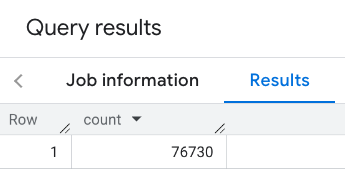
The simplest PLACES_COUNT function call returns a single count of all places in a geographical area. In this example, you return the count of all operational places within 1000 meters of the Empire State building.
В этом примере используется функция BigQuery ST_GEOGPOINT для возврата значения GEOGRAPHY из заданной точки.
SELECT `PROJECT_NAME.places_insights___us.PLACES_COUNT`(
  JSON_OBJECT(
      'geography', ST_GEOGPOINT(-73.9857, 40.7484), -- Empire State Building
      'geography_radius', 1000 -- Radius in meters
      )
) as count;
Ответ содержит одно значение:
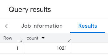
Более типичный вызов применяет фильтры к области поиска. В следующем примере используются фильтры для ограничения поиска и получения только следующих результатов:
- Заведения
restaurantтипа с минимальным рейтингом 3 - Уровень цен: недорогой или средний
- В настоящее время функционирует
- Разрешено выгуливать собак.
SELECT `PROJECT_NAME.places_insights___us.PLACES_COUNT`(
  JSON_OBJECT(
      'geography', ST_GEOGPOINT(-73.9857, 40.7484), -- Empire State Building
      'geography_radius', 1000, -- Radius in meters
      'types', ["restaurant"],
      'min_rating', 3,
      'price_level', ['PRICE_LEVEL_INEXPENSIVE', 'PRICE_LEVEL_MODERATE'],
      'business_status', ['OPERATIONAL'],
      'allows_dogs', TRUE
      )
) as count;
Отфильтрованный ответ:
Помните, что запросы к набору данных мест устанавливают минимальный пороговый уровень в 5. Одним из преимуществ функций подсчета мест является то, что они могут возвращать любые значения, включая 0. Например, следующий вызов возвращает значение 1:
SELECT `PROJECT_NAME.places_insights___us.PLACES_COUNT`(
  JSON_OBJECT(
      'geography', ST_GEOGPOINT(-73.9857, 40.7484), -- Empire State Building
      'geography_radius', 500, -- Radius in meters
      'types', ["restaurant"],
      'min_rating', 4.0,
      'free_parking_lot', TRUE,
      'good_for_watching_sports', TRUE
      )
) as count;
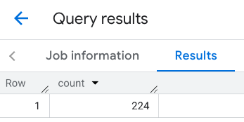
Пример: Рассчитайте количество ресторанов, используя многоугольник.
Для задания области поиска можно использовать многоугольник. При использовании многоугольника его точки должны образовывать замкнутый контур, где первая точка многоугольника совпадает с последней точкой.
В этом примере используется функция BigQuery ST_GEOGFROMTEXT для возврата значения GEOGRAPHY из полигона.
DECLARE geo GEOGRAPHY;
SET geo = ST_GEOGFROMTEXT('''POLYGON((-73.985708 40.75773,-73.993324 40.750298,
                                      -73.9857 40.7484,-73.9785 40.7575,
                                      -73.985708 40.75773))''');  -- NYC viewport

SELECT `PROJECT_NAME.places_insights___us.PLACES_COUNT`(
  JSON_OBJECT(
      'geography',geo, -- viewport
      'types', ["restaurant"],
      'min_rating', 1.0,
      'max_rating', 4.5,
      'min_user_rating_count', 1,
      'max_user_rating_count', 10000,
      'price_level', ['PRICE_LEVEL_INEXPENSIVE', 'PRICE_LEVEL_MODERATE'],
      'business_status', ['OPERATIONAL'],
      'allows_dogs', TRUE
      )
) as count;
Ответ для области просмотра:
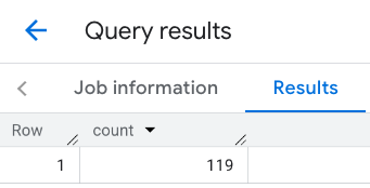
Пример: Рассчитайте количество ресторанов, используя линию.
В следующем примере область поиска определяется с помощью линии, соединяющей точки, с радиусом поиска 100 метров вокруг этой линии. Линия похожа на маршрут, рассчитываемый с помощью API маршрутов . Маршрут может быть предназначен для транспортного средства, велосипеда или пешехода:
DECLARE geo GEOGRAPHY;
SET geo = ST_GEOGFROMTEXT('LINESTRING(-73.98903537033028 40.73655649223003,-73.93580216278471 40.80955538843361)');  -- NYC line

SELECT `PROJECT_NAME.places_insights___us.PLACES_COUNT`(
  JSON_OBJECT(
      'geography',geo, -- line
      'geography_radius', 100, -- Radius around line
      'types', ["restaurant"],
      'min_rating', 1.0,
      'max_rating', 4.5,
      'min_user_rating_count', 1,
      'max_user_rating_count', 10000,
      'price_level', ['PRICE_LEVEL_INEXPENSIVE', 'PRICE_LEVEL_MODERATE'],
      'business_status', ['OPERATIONAL'],
      'allows_dogs', TRUE
      )
) as count;
Ответ на эту строку:
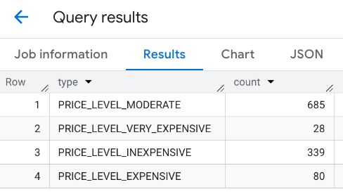
Пример: Объединение результатов нескольких вызовов.
Вы можете объединить результаты нескольких вызовов функции PLACES_COUNT . Например, вам нужен один результат, показывающий количество ресторанов следующих ценовых категорий в определенном районе:
-
PRICE_LEVEL_INEXPENSIVE -
PRICE_LEVEL_MODERATE -
PRICE_LEVEL_EXPENSIVE -
PRICE_LEVEL_VERY_EXPENSIVE"
В этом примере вы создаете цикл для вызова функции PLACES_COUNT для каждого уровня цен и вставляете результаты каждого вызова во временную таблицу. Затем вы выполняете запрос к временной таблице для отображения результатов:
-- Create a temp table to hold the results.
CREATE TEMP TABLE results (type STRING, count INT64);

-- Create a loop that calls PLACES_COUNT for each price level.
FOR types IN (SELECT type FROM UNNEST(["PRICE_LEVEL_INEXPENSIVE", "PRICE_LEVEL_MODERATE", "PRICE_LEVEL_EXPENSIVE", "PRICE_LEVEL_VERY_EXPENSIVE"]) as type)
DO
  INSERT INTO results VALUES (types.type, `PROJECT_NAME.places_insights___us.PLACES_COUNT`(
  JSON_OBJECT(
      'types', ["restaurant"],
      'geography', ST_GEOGPOINT(-73.9857, 40.7484), -- Empire State Building
      'geography_radius', 1000, -- Radius in meters
      'business_status', ['OPERATIONAL'],
      'price_level', [types.type]
  )));
END FOR;

-- Query the table of results.
SELECT * FROM results;
Совокупный ответ:
Другой вариант — использовать команду UNION ALL для объединения результатов нескольких операторов SELECT . В следующем примере показаны те же результаты, что и в предыдущем:
SELECT "PRICE_LEVEL_INEXPENSIVE" as price_level, `PROJECT_NAME.places_insights___us.PLACES_COUNT`(
  JSON_OBJECT(
      'types', ["restaurant"],
      'geography', ST_GEOGPOINT(-73.9857, 40.7484), -- Empire State Building
      'geography_radius', 1000, -- Radius in meters
      'business_status', ['OPERATIONAL'],
      'price_level', ['PRICE_LEVEL_INEXPENSIVE']
  )
) as count

UNION ALL

SELECT "PRICE_LEVEL_MODERATE" as price_level, `PROJECT_NAME.places_insights___us.PLACES_COUNT`(
  JSON_OBJECT(
      'types', ["restaurant"],
      'geography', ST_GEOGPOINT(-73.9857, 40.7484), -- Empire State Building
      'geography_radius', 1000, -- Radius in meters
      'business_status', ['OPERATIONAL'],
      'price_level', ['PRICE_LEVEL_MODERATE']
  )
) as count

UNION ALL

SELECT "PRICE_LEVEL_EXPENSIVE" as price_level, `PROJECT_NAME.places_insights___us.PLACES_COUNT`(
  JSON_OBJECT(
      'types', ["restaurant"],
      'geography', ST_GEOGPOINT(-73.9857, 40.7484), -- Empire State Building
      'geography_radius', 1000, -- Radius in meters
      'business_status', ['OPERATIONAL'],
      'price_level', ['PRICE_LEVEL_EXPENSIVE']
  )
) as count

UNION ALL

SELECT "PRICE_LEVEL_VERY_EXPENSIVE" as price_level, `PROJECT_NAME.places_insights___us.PLACES_COUNT`(
  JSON_OBJECT(
      'types', ["restaurant"],
      'geography', ST_GEOGPOINT(-73.9857, 40.7484), -- Empire State Building
      'geography_radius', 1000, -- Radius in meters
      'business_status', ['OPERATIONAL'],
      'price_level', ['PRICE_LEVEL_VERY_EXPENSIVE']
  )
) as count