
Funkcja PLACES_COUNT zwraca pojedynczą wartość liczby miejsc na podstawie określonego obszaru wyszukiwania i filtrów wyszukiwania. Musisz określić obszar wyszukiwania w funkcji PLACES_COUNT i opcjonalnie możesz podać dodatkowe parametry filtra, takie jak typ miejsca, status działalności, poziom cenowy i inne.
Ponieważ funkcja PLACES_COUNT zwraca pojedynczą wartość, wywołaj ją za pomocą klauzuli SELECT.
Parametry wejściowe:
Wymagany:
geographyparametr filtra, który określa obszar wyszukiwania. Parametrgeographyprzyjmuje wartość zdefiniowaną przez typ danych BigQueryGEOGRAPHY, który obsługuje punkty, linie i wielokąty.Opcjonalne: dodatkowe parametry filtra, które pozwalają zawęzić wyszukiwanie.
Zwraca:
- Pojedyncza wartość
countjakoINT64.
- Pojedyncza wartość
Przykład: obliczanie liczby miejsc w promieniu wyszukiwania
Najprostsze wywołanie funkcji PLACES_COUNT zwraca pojedynczą liczbę wszystkich miejsc w obszarze geograficznym. W tym przykładzie zwracamy liczbę wszystkich działających miejsc w promieniu 1000 metrów od Empire State Building.
Ten przykład używa funkcji BigQuery
ST_GEOGPOINT
, aby zwrócić wartość GEOGRAPHY z punktu.
SELECT `PROJECT_NAME.places_insights___us.PLACES_COUNT`(
  JSON_OBJECT(
      'geography', ST_GEOGPOINT(-73.9857, 40.7484), -- Empire State Building
      'geography_radius', 1000 -- Radius in meters
      )
) as count;
Odpowiedź zawiera pojedynczą liczbę:
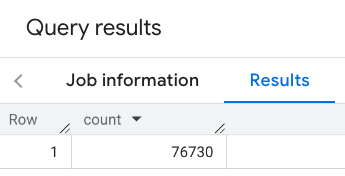
Bardziej typowe wywołanie stosuje filtry do obszaru wyszukiwania. Poniższy przykład używa filtrów, aby ograniczyć wyszukiwanie i zwrócić tylko liczbę:
- miejsc typu
restaurantz minimalną oceną 3, - poziomem cenowym tanim lub średnim,
- obecnie działających,
- do których można wejść z psem.
SELECT `PROJECT_NAME.places_insights___us.PLACES_COUNT`(
  JSON_OBJECT(
      'geography', ST_GEOGPOINT(-73.9857, 40.7484), -- Empire State Building
      'geography_radius', 1000, -- Radius in meters
      'types', ["restaurant"],
      'min_rating', 3,
      'price_level', ['PRICE_LEVEL_INEXPENSIVE', 'PRICE_LEVEL_MODERATE'],
      'business_status', ['OPERATIONAL'],
      'allows_dogs', TRUE
      )
) as count;
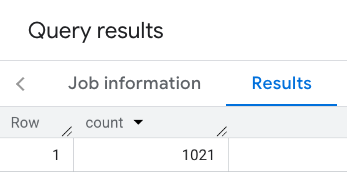
Odpowiedź po zastosowaniu filtrów:
Pamiętaj, że zapytania dotyczące zbioru danych o miejscach wymuszają minimalny próg liczby wynoszący 5. Jedną z zalet funkcji zliczania miejsc jest to, że mogą one zwracać dowolne liczby, w tym 0. Na przykład to wywołanie zwraca liczbę 1:
SELECT `PROJECT_NAME.places_insights___us.PLACES_COUNT`(
  JSON_OBJECT(
      'geography', ST_GEOGPOINT(-73.9857, 40.7484), -- Empire State Building
      'geography_radius', 500, -- Radius in meters
      'types', ["restaurant"],
      'min_rating', 4.0,
      'free_parking_lot', TRUE,
      'good_for_watching_sports', TRUE
      )
) as count;
Przykład: obliczanie liczby restauracji za pomocą wielokąta
Do określenia obszaru wyszukiwania możesz użyć wielokąta. W przypadku użycia wielokąta jego punkty muszą tworzyć zamkniętą pętlę, w której pierwszy punkt jest taki sam jak ostatni.
Ten przykład używa funkcji BigQuery
ST_GEOGFROMTEXT
, aby zwrócić wartość GEOGRAPHY z wielokąta.
DECLARE geo GEOGRAPHY;
SET geo = ST_GEOGFROMTEXT('''POLYGON((-73.985708 40.75773,-73.993324 40.750298,
                                      -73.9857 40.7484,-73.9785 40.7575,
                                      -73.985708 40.75773))''');  -- NYC viewport

SELECT `PROJECT_NAME.places_insights___us.PLACES_COUNT`(
  JSON_OBJECT(
      'geography',geo, -- viewport
      'types', ["restaurant"],
      'min_rating', 1.0,
      'max_rating', 4.5,
      'min_user_rating_count', 1,
      'max_user_rating_count', 10000,
      'price_level', ['PRICE_LEVEL_INEXPENSIVE', 'PRICE_LEVEL_MODERATE'],
      'business_status', ['OPERATIONAL'],
      'allows_dogs', TRUE
      )
) as count;
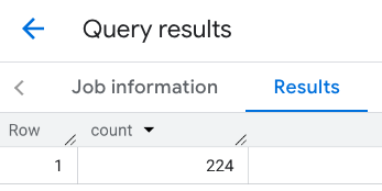
Odpowiedź dla widocznego obszaru:
Przykład: obliczanie liczby restauracji za pomocą linii
W następnym przykładzie obszar wyszukiwania jest definiowany za pomocą linii połączonych punktów z promieniem wyszukiwania wynoszącym 100 metrów wokół linii. Linia jest podobna do trasy podróży obliczonej przez interfejs Routes API. Trasa może być przeznaczona dla pojazdu, roweru lub pieszego:
DECLARE geo GEOGRAPHY;
SET geo = ST_GEOGFROMTEXT('LINESTRING(-73.98903537033028 40.73655649223003,-73.93580216278471 40.80955538843361)');  -- NYC line

SELECT `PROJECT_NAME.places_insights___us.PLACES_COUNT`(
  JSON_OBJECT(
      'geography',geo, -- line
      'geography_radius', 100, -- Radius around line
      'types', ["restaurant"],
      'min_rating', 1.0,
      'max_rating', 4.5,
      'min_user_rating_count', 1,
      'max_user_rating_count', 10000,
      'price_level', ['PRICE_LEVEL_INEXPENSIVE', 'PRICE_LEVEL_MODERATE'],
      'business_status', ['OPERATIONAL'],
      'allows_dogs', TRUE
      )
) as count;
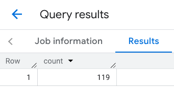
Odpowiedź dla linii:
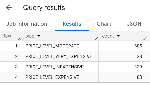
Przykład: łączenie wyników wielu wywołań
Możesz łączyć wyniki wielu wywołań funkcji PLACES_COUNT.
Na przykład chcesz uzyskać pojedynczy wynik pokazujący liczbę restauracji w określonym obszarze dla tych poziomów cenowych:
PRICE_LEVEL_INEXPENSIVEPRICE_LEVEL_MODERATEPRICE_LEVEL_EXPENSIVEPRICE_LEVEL_VERY_EXPENSIVE"
W tym przykładzie tworzysz pętlę, aby wywołać funkcję PLACES_COUNT dla każdego poziomu cenowego, i wstawiasz wyniki każdego wywołania do tabeli tymczasowej. Następnie wysyłasz zapytanie do tabeli tymczasowej, aby wyświetlić wyniki:
-- Create a temp table to hold the results.
CREATE TEMP TABLE results (type STRING, count INT64);

-- Create a loop that calls PLACES_COUNT for each price level.
FOR types IN (SELECT type FROM UNNEST(["PRICE_LEVEL_INEXPENSIVE", "PRICE_LEVEL_MODERATE", "PRICE_LEVEL_EXPENSIVE", "PRICE_LEVEL_VERY_EXPENSIVE"]) as type)
DO
  INSERT INTO results VALUES (types.type, `PROJECT_NAME.places_insights___us.PLACES_COUNT`(
  JSON_OBJECT(
      'types', ["restaurant"],
      'geography', ST_GEOGPOINT(-73.9857, 40.7484), -- Empire State Building
      'geography_radius', 1000, -- Radius in meters
      'business_status', ['OPERATIONAL'],
      'price_level', [types.type]
  )));
END FOR;

-- Query the table of results.
SELECT * FROM results;
Połączona odpowiedź:
Inną opcją jest użycie polecenia UNION ALL, aby połączyć wyniki wielu instrukcji SELECT. Poniższy przykład pokazuje te same wyniki co poprzedni:
SELECT "PRICE_LEVEL_INEXPENSIVE" as price_level, `PROJECT_NAME.places_insights___us.PLACES_COUNT`(
  JSON_OBJECT(
      'types', ["restaurant"],
      'geography', ST_GEOGPOINT(-73.9857, 40.7484), -- Empire State Building
      'geography_radius', 1000, -- Radius in meters
      'business_status', ['OPERATIONAL'],
      'price_level', ['PRICE_LEVEL_INEXPENSIVE']
  )
) as count

UNION ALL

SELECT "PRICE_LEVEL_MODERATE" as price_level, `PROJECT_NAME.places_insights___us.PLACES_COUNT`(
  JSON_OBJECT(
      'types', ["restaurant"],
      'geography', ST_GEOGPOINT(-73.9857, 40.7484), -- Empire State Building
      'geography_radius', 1000, -- Radius in meters
      'business_status', ['OPERATIONAL'],
      'price_level', ['PRICE_LEVEL_MODERATE']
  )
) as count

UNION ALL

SELECT "PRICE_LEVEL_EXPENSIVE" as price_level, `PROJECT_NAME.places_insights___us.PLACES_COUNT`(
  JSON_OBJECT(
      'types', ["restaurant"],
      'geography', ST_GEOGPOINT(-73.9857, 40.7484), -- Empire State Building
      'geography_radius', 1000, -- Radius in meters
      'business_status', ['OPERATIONAL'],
      'price_level', ['PRICE_LEVEL_EXPENSIVE']
  )
) as count

UNION ALL

SELECT "PRICE_LEVEL_VERY_EXPENSIVE" as price_level, `PROJECT_NAME.places_insights___us.PLACES_COUNT`(
  JSON_OBJECT(
      'types', ["restaurant"],
      'geography', ST_GEOGPOINT(-73.9857, 40.7484), -- Empire State Building
      'geography_radius', 1000, -- Radius in meters
      'business_status', ['OPERATIONAL'],
      'price_level', ['PRICE_LEVEL_VERY_EXPENSIVE']
  )
) as count