science Ce produit ou cette fonctionnalité est en phase expérimentale (pré-DG). La compatibilité des fonctionnalités et produits pré-DG peut être limitée, et il se peut que les modifications apportées à ces fonctionnalités ou produits ne soient pas compatibles avec d'autres versions pré-DG. Les offres en pré-DG sont couvertes par les Conditions spécifiques du service Google Maps Platform. Pour en savoir plus, consultez les descriptions des étapes de lancement. Inscrivez-vous pour tester les insights sur les lieux.
Restez organisé à l'aide des collections
Enregistrez et classez les contenus selon vos préférences.
La fonction PLACES_COUNT renvoie une seule valeur de nombre de lieux en fonction de la zone de recherche et des filtres de recherche spécifiés. Vous devez spécifier la zone de recherche dans la fonction PLACES_COUNT et pouvez éventuellement spécifier des paramètres de filtre supplémentaires, tels que le type de lieu, l'état de fonctionnement, le niveau de prix, etc.
Étant donné que la fonction PLACES_COUNT renvoie une seule valeur, appelez-la à l'aide d'une clause SELECT.
Paramètres d'entrée :
Obligatoire : le paramètre de filtregeography qui spécifie la zone de recherche. Le paramètre geography accepte une valeur définie par le type de données BigQuery GEOGRAPHY, qui est compatible avec les points, les chaînes linéaires et les polygones.
Facultatif : paramètres de filtre supplémentaires pour affiner votre recherche.
Renvoie :
Une seule valeur count sous forme de INT64.
Exemple : Calculer le nombre de lieux dans un rayon de recherche
L'appel de fonction PLACES_COUNT le plus simple renvoie un seul nombre de lieux dans une zone géographique. Dans cet exemple, vous renvoyez le nombre de lieux opérationnels situés à moins de 1 000 mètres de l'Empire State Building.
Cet exemple utilise la fonction BigQuery ST_GEOGPOINT pour renvoyer une valeur GEOGRAPHY à partir d'un point.
SELECT`places_insights___us___sample.PLACES_COUNT`(JSON_OBJECT('geography',ST_GEOGPOINT(-73.9857,40.7484),-- Empire State Building'geography_radius',1000-- Radius in meters))ascount;
La réponse contient un seul décompte :
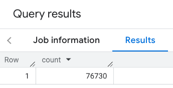
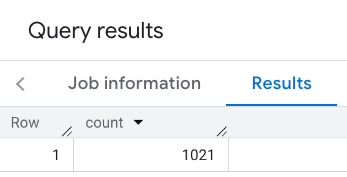
Un appel plus typique applique des filtres à la zone de recherche. L'exemple suivant utilise des filtres pour limiter la recherche et ne renvoyer qu'un nombre :
Lieux de type restaurant avec une note minimale de 3
un niveau de prix "bon marché" ou "moyen" ;
Actuellement opérationnel
Accepte les chiens
SELECT`places_insights___us___sample.PLACES_COUNT`(JSON_OBJECT('geography',ST_GEOGPOINT(-73.9857,40.7484),-- Empire State Building'geography_radius',1000,-- Radius in meters'types',["restaurant"],'min_rating',3,'price_level',['PRICE_LEVEL_INEXPENSIVE','PRICE_LEVEL_MODERATE'],'business_status',['OPERATIONAL'],'allows_dogs',TRUE))ascount;
Réponse filtrée :
N'oubliez pas que les requêtes sur les ensembles de données de lieux appliquent un seuil minimal de 5 comptes. L'un des avantages des fonctions de nombre de lieux est qu'elles peuvent renvoyer n'importe quel nombre, y compris 0. Par exemple, l'appel suivant renvoie un nombre de 1 :
SELECT`places_insights___us___sample.PLACES_COUNT`(JSON_OBJECT('geography',ST_GEOGPOINT(-73.9857,40.7484),-- Empire State Building'geography_radius',500,-- Radius in meters'types',["restaurant"],'min_rating',4.0,'free_parking_lot',TRUE,'good_for_watching_sports',TRUE))ascount;
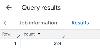
Exemple : Calculer le nombre de restaurants à l'aide d'un polygone
Vous pouvez utiliser un polygone pour spécifier la zone de recherche. Lorsque vous utilisez un polygone, ses points doivent définir une boucle fermée, c'est-à-dire que le premier point du polygone doit être identique au dernier.
Cet exemple utilise la fonction BigQuery ST_GEOGFROMTEXT pour renvoyer une valeur GEOGRAPHY à partir d'un polygone.
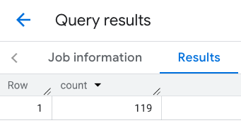
Exemple : Calculer le nombre de restaurants à l'aide d'une ligne
Dans l'exemple suivant, vous définissez la zone de recherche à l'aide d'une ligne de points connectés avec un rayon de recherche de 100 mètres autour de la ligne.
Cette ligne est semblable à un itinéraire de voyage calculé par l'API Routes. L'itinéraire peut être destiné à un véhicule, à un vélo ou à un piéton :
DECLAREgeoGEOGRAPHY;SETgeo=ST_GEOGFROMTEXT('LINESTRING(-73.98903537033028 40.73655649223003,-73.93580216278471 40.80955538843361)');-- NYC lineSELECT`places_insights___us___sample.PLACES_COUNT`(JSON_OBJECT('geography',geo,-- line'geography_radius',100,-- Radius around line'types',["restaurant"],'min_rating',1.0,'max_rating',4.5,'min_user_rating_count',1,'max_user_rating_count',10000,'price_level',['PRICE_LEVEL_INEXPENSIVE','PRICE_LEVEL_MODERATE'],'business_status',['OPERATIONAL'],'allows_dogs',TRUE))ascount;
Réponse pour la ligne :
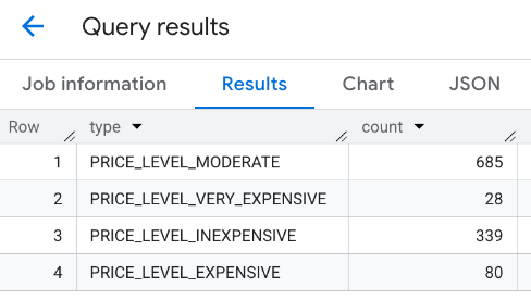
Exemple : Combiner les résultats de plusieurs appels
Vous pouvez combiner les résultats de plusieurs appels à la fonction PLACES_COUNT.
Par exemple, vous souhaitez obtenir un seul résultat indiquant le nombre de restaurants pour les gammes de prix suivantes dans une zone spécifique :
PRICE_LEVEL_INEXPENSIVE
PRICE_LEVEL_MODERATE
PRICE_LEVEL_EXPENSIVE
PRICE_LEVEL_VERY_EXPENSIVE"
Dans cet exemple, vous créez une boucle pour appeler la fonction PLACES_COUNT pour chaque niveau de prix et insérer les résultats de chaque appel dans une table temporaire. Vous interrogez ensuite la table temporaire pour afficher les résultats :
-- Create a temp table to hold the results.CREATETEMPTABLEresults(typeSTRING,countINT64);-- Create a loop that calls PLACES_COUNT for each price level.FORtypesIN(SELECTtypeFROMUNNEST(["PRICE_LEVEL_INEXPENSIVE","PRICE_LEVEL_MODERATE","PRICE_LEVEL_EXPENSIVE","PRICE_LEVEL_VERY_EXPENSIVE"])astype)DOINSERTINTOresultsVALUES(types.type,`places_insights___us___sample.PLACES_COUNT`(JSON_OBJECT('types',["restaurant"],'geography',ST_GEOGPOINT(-73.9857,40.7484),-- Empire State Building'geography_radius',1000,-- Radius in meters'business_status',['OPERATIONAL'],'price_level',[types.type])));ENDFOR;-- Query the table of results.SELECT*FROMresults;
Réponse combinée :
Vous pouvez également utiliser la commande UNION ALL pour combiner les résultats de plusieurs instructions SELECT. L'exemple suivant affiche les mêmes résultats que l'exemple précédent :
SELECT"PRICE_LEVEL_INEXPENSIVE"asprice_level,`places_insights___us___sample.PLACES_COUNT`(JSON_OBJECT('types',["restaurant"],'geography',ST_GEOGPOINT(-73.9857,40.7484),-- Empire State Building'geography_radius',1000,-- Radius in meters'business_status',['OPERATIONAL'],'price_level',['PRICE_LEVEL_INEXPENSIVE']))ascountUNIONALLSELECT"PRICE_LEVEL_MODERATE"asprice_level,`places_insights___us___sample.PLACES_COUNT`(JSON_OBJECT('types',["restaurant"],'geography',ST_GEOGPOINT(-73.9857,40.7484),-- Empire State Building'geography_radius',1000,-- Radius in meters'business_status',['OPERATIONAL'],'price_level',['PRICE_LEVEL_MODERATE']))ascountUNIONALLSELECT"PRICE_LEVEL_EXPENSIVE"asprice_level,`places_insights___us___sample.PLACES_COUNT`(JSON_OBJECT('types',["restaurant"],'geography',ST_GEOGPOINT(-73.9857,40.7484),-- Empire State Building'geography_radius',1000,-- Radius in meters'business_status',['OPERATIONAL'],'price_level',['PRICE_LEVEL_EXPENSIVE']))ascountUNIONALLSELECT"PRICE_LEVEL_VERY_EXPENSIVE"asprice_level,`places_insights___us___sample.PLACES_COUNT`(JSON_OBJECT('types',["restaurant"],'geography',ST_GEOGPOINT(-73.9857,40.7484),-- Empire State Building'geography_radius',1000,-- Radius in meters'business_status',['OPERATIONAL'],'price_level',['PRICE_LEVEL_VERY_EXPENSIVE']))ascount
Sauf indication contraire, le contenu de cette page est régi par une licence Creative Commons Attribution 4.0, et les échantillons de code sont régis par une licence Apache 2.0. Pour en savoir plus, consultez les Règles du site Google Developers. Java est une marque déposée d'Oracle et/ou de ses sociétés affiliées.
Dernière mise à jour le 2025/09/06 (UTC).
[[["Facile à comprendre","easyToUnderstand","thumb-up"],["J'ai pu résoudre mon problème","solvedMyProblem","thumb-up"],["Autre","otherUp","thumb-up"]],[["Il n'y a pas l'information dont j'ai besoin","missingTheInformationINeed","thumb-down"],["Trop compliqué/Trop d'étapes","tooComplicatedTooManySteps","thumb-down"],["Obsolète","outOfDate","thumb-down"],["Problème de traduction","translationIssue","thumb-down"],["Mauvais exemple/Erreur de code","samplesCodeIssue","thumb-down"],["Autre","otherDown","thumb-down"]],["Dernière mise à jour le 2025/09/06 (UTC)."],[],[],null,["The `PLACES_COUNT` function returns a single count value of places based on the\nspecified search area and search filters. You must specify the search area to\nthe `PLACES_COUNT` function and can optionally specify additional filter\nparameters, such as place type, operating status, price level, and more.\n\nBecause the `PLACES_COUNT` function returns a single value, call it using\na `SELECT` clause.\n\n- Input parameters:\n\n - **Required** : The `geography` [filter parameter](/maps/documentation/placesinsights/experimental/filter-params) that\n specifies the search area. The `geography` parameter takes a value defined\n by the BigQuery\n [`GEOGRAPHY`](https://cloud.google.com/bigquery/docs/reference/standard-sql/data-types#geography_type)\n data type, which supports points, linestrings, and polygons.\n\n - **Optional** : Additional [filter](/maps/documentation/placesinsights/experimental/filter-params) parameters to refine your\n search.\n\n- Returns:\n\n - A single `count` value as an `INT64`.\n\nExample: Calculate the number of places in a search radius\n\nThe simplest `PLACES_COUNT` function call returns a single count of all places\nin a geographical area. In this example, you return the count of all operational\nplaces within 1000 meters of the Empire State building.\n\nThis example uses the BigQuery\n[`ST_GEOGPOINT`](https://cloud.google.com/bigquery/docs/reference/standard-sql/geography_functions#st_geogpoint)\nfunction to return a `GEOGRAPHY` value from a point. \n\n```googlesql\nSELECT `maps-platform-analytics-hub.sample_places_insights_us.PLACES_COUNT`(\n JSON_OBJECT(\n 'geography', ST_GEOGPOINT(-73.9857, 40.7484), -- Empire State Building\n 'geography_radius', 1000 -- Radius in meters\n )\n) as count;\n```\n\nThe response contains a single count:\n\nA more typical call applies filters to the search area. The next example uses\nfilters to limit the search to only return a count of:\n\n- Places of type `restaurant` with the minimum rating of 3\n- A price level of inexpensive or medium\n- Currently operational\n- Allows dogs\n\n```googlesql\nSELECT `maps-platform-analytics-hub.sample_places_insights_us.PLACES_COUNT`(\n JSON_OBJECT(\n 'geography', ST_GEOGPOINT(-73.9857, 40.7484), -- Empire State Building\n 'geography_radius', 1000, -- Radius in meters\n 'types', [\"restaurant\"],\n 'min_rating', 3,\n 'price_level', ['PRICE_LEVEL_INEXPENSIVE', 'PRICE_LEVEL_MODERATE'],\n 'business_status', ['OPERATIONAL'],\n 'allows_dogs', TRUE\n )\n) as count;\n```\n\nThe filtered response:\n\nRemember that place dataset queries enforce a minimum count threshold of\n5. One of the advantages of the place count functions is\nthat they can return any counts, including 0. For example, the following call\nreturns a count of 1: \n\n```googlesql\nSELECT `maps-platform-analytics-hub.sample_places_insights_us.PLACES_COUNT`(\n JSON_OBJECT(\n 'geography', ST_GEOGPOINT(-73.9857, 40.7484), -- Empire State Building\n 'geography_radius', 500, -- Radius in meters\n 'types', [\"restaurant\"],\n 'min_rating', 4.0,\n 'free_parking_lot', TRUE,\n 'good_for_watching_sports', TRUE\n )\n) as count;\n```\n\nExample: Calculate the number of restaurants using a polygon\n\nYou can use a polygon to specify the search area. When using a polygon,\nthe points of the polygon must define a closed loop where the first point in the\npolygon is the same as the last point.\n\nThis example uses the BigQuery\n[`ST_GEOGFROMTEXT`](https://cloud.google.com/bigquery/docs/reference/standard-sql/geography_functions#st_geogfromtext)\nfunction to return a `GEOGRAPHY` value from a polygon. \n\n```googlesql\nDECLARE geo GEOGRAPHY;\nSET geo = ST_GEOGFROMTEXT('''POLYGON((-73.985708 40.75773,-73.993324 40.750298,\n -73.9857 40.7484,-73.9785 40.7575,\n -73.985708 40.75773))'''); -- NYC viewport\n\nSELECT `maps-platform-analytics-hub.sample_places_insights_us.PLACES_COUNT`(\n JSON_OBJECT(\n 'geography',geo, -- viewport \n 'types', [\"restaurant\"],\n 'min_rating', 1.0,\n 'max_rating', 4.5,\n 'min_user_rating_count', 1,\n 'max_user_rating_count', 10000,\n 'price_level', ['PRICE_LEVEL_INEXPENSIVE', 'PRICE_LEVEL_MODERATE'],\n 'business_status', ['OPERATIONAL'],\n 'allows_dogs', TRUE\n )\n) as count;\n```\n\nThe response for the viewport:\n\nExample: Calculate the number of restaurants using a line\n\nIn the next example, you define the search area using a line of connected\npoints with a search radius of 100 meters around the line.\nThe line is similar to a travel route calculated by the [Routes\nAPI](/maps/documentation/routes). The route might be for a vehicle, a bicycle,\nor for a pedestrian: \n\n```googlesql\nDECLARE geo GEOGRAPHY;\nSET geo = ST_GEOGFROMTEXT('LINESTRING(-73.98903537033028 40.73655649223003,-73.93580216278471 40.80955538843361)'); -- NYC line\n\nSELECT `maps-platform-analytics-hub.sample_places_insights_us.PLACES_COUNT`(\n JSON_OBJECT(\n 'geography',geo, -- line\n 'geography_radius', 100, -- Radius around line\n 'types', [\"restaurant\"],\n 'min_rating', 1.0,\n 'max_rating', 4.5,\n 'min_user_rating_count', 1,\n 'max_user_rating_count', 10000,\n 'price_level', ['PRICE_LEVEL_INEXPENSIVE', 'PRICE_LEVEL_MODERATE'],\n 'business_status', ['OPERATIONAL'],\n 'allows_dogs', TRUE\n )\n) as count;\n```\n\nThe response for the line:\n\nExample: Combine the results of multiple calls\n\nYou can combine the results of multiple calls to the `PLACES_COUNT` function.\nFor example, you want a single result showing the number of restaurants for\nthe following price levels within a specific area:\n\n- `PRICE_LEVEL_INEXPENSIVE`\n- `PRICE_LEVEL_MODERATE`\n- `PRICE_LEVEL_EXPENSIVE`\n- `PRICE_LEVEL_VERY_EXPENSIVE\"`\n\nIn this example, you create a loop to call the `PLACES_COUNT` function for each\nprice level, and insert the results of each call to a temporary table. You then\nquery the temporary table to display the results: \n\n```googlesql\n-- Create a temp table to hold the results.\nCREATE TEMP TABLE results (type STRING, count INT64);\n\n-- Create a loop that calls PLACES_COUNT for each price level.\nFOR types IN (SELECT type FROM UNNEST([\"PRICE_LEVEL_INEXPENSIVE\", \"PRICE_LEVEL_MODERATE\", \"PRICE_LEVEL_EXPENSIVE\", \"PRICE_LEVEL_VERY_EXPENSIVE\"]) as type)\nDO\n INSERT INTO results VALUES (types.type, `maps-platform-analytics-hub.sample_places_insights_us.PLACES_COUNT`(\n JSON_OBJECT(\n 'types', [\"restaurant\"],\n 'geography', ST_GEOGPOINT(-73.9857, 40.7484), -- Empire State Building\n 'geography_radius', 1000, -- Radius in meters\n 'business_status', ['OPERATIONAL'],\n 'price_level', [types.type]\n )));\nEND FOR;\n\n-- Query the table of results.\nSELECT * FROM results;\n```\n\nThe combined response:\n\nAnother option is to use the `UNION ALL` command to combine the results of\nmultiple `SELECT` statements. The following example shows the same results as\nfrom the previous example: \n\n```googlesql\nSELECT \"PRICE_LEVEL_INEXPENSIVE\" as price_level, `maps-platform-analytics-hub.sample_places_insights_us.PLACES_COUNT`(\n JSON_OBJECT(\n 'types', [\"restaurant\"],\n 'geography', ST_GEOGPOINT(-73.9857, 40.7484), -- Empire State Building\n 'geography_radius', 1000, -- Radius in meters\n 'business_status', ['OPERATIONAL'],\n 'price_level', ['PRICE_LEVEL_INEXPENSIVE']\n )\n) as count\n\nUNION ALL\n\nSELECT \"PRICE_LEVEL_MODERATE\" as price_level, `maps-platform-analytics-hub.sample_places_insights_us.PLACES_COUNT`(\n JSON_OBJECT(\n 'types', [\"restaurant\"],\n 'geography', ST_GEOGPOINT(-73.9857, 40.7484), -- Empire State Building\n 'geography_radius', 1000, -- Radius in meters\n 'business_status', ['OPERATIONAL'],\n 'price_level', ['PRICE_LEVEL_MODERATE']\n )\n) as count\n\nUNION ALL\n\nSELECT \"PRICE_LEVEL_EXPENSIVE\" as price_level, `maps-platform-analytics-hub.sample_places_insights_us.PLACES_COUNT`(\n JSON_OBJECT(\n 'types', [\"restaurant\"],\n 'geography', ST_GEOGPOINT(-73.9857, 40.7484), -- Empire State Building\n 'geography_radius', 1000, -- Radius in meters\n 'business_status', ['OPERATIONAL'],\n 'price_level', ['PRICE_LEVEL_EXPENSIVE']\n )\n) as count\n\nUNION ALL\n\nSELECT \"PRICE_LEVEL_VERY_EXPENSIVE\" as price_level, `maps-platform-analytics-hub.sample_places_insights_us.PLACES_COUNT`(\n JSON_OBJECT(\n 'types', [\"restaurant\"],\n 'geography', ST_GEOGPOINT(-73.9857, 40.7484), -- Empire State Building\n 'geography_radius', 1000, -- Radius in meters\n 'business_status', ['OPERATIONAL'],\n 'price_level', ['PRICE_LEVEL_VERY_EXPENSIVE']\n )\n) as count\n```"]]