Page Summary
-
GlobFire provides daily and final fire boundaries based on the MODIS MCD64A1 dataset, identifying each fire event with a unique number.
-
The GlobFire data are computed using an algorithm that encodes space-time relationships among burned area patches in a graph structure.
-
The MCD64A1 Version 6.1 product offers monthly, global 500m gridded burned-area and quality information based on MODIS Surface Reflectance and active fire observations.
-
GlobFire Daily Fire Event Detection Based on MCD64A1
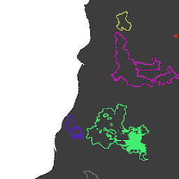
Fire boundaries based on the MODIS dataset MCD64A1. The data were computed based on an algorithm that relies on encoding in a graph structure a space-time relationship among patches of burned areas. Each fire has a unique number identifying the event. area burnt disaster fire globfire mcd64a1 -
GlobFire Final Fire Event Detection Based on MCD64A1

Fire boundaries based on the MODIS dataset MCD64A1. The data were computed based on an algorithm that relies on encoding in a graph structure a space-time relationship among patches of burned areas. Each fire has a unique number identifying the event. area burnt disaster fire globfire mcd64a1 -
MCD64A1.061 MODIS Burned Area Monthly Global 500m
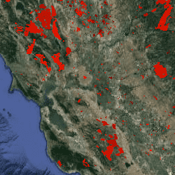
The Terra and Aqua combined MCD64A1 Version 6.1 Burned Area data product is a monthly, global gridded 500m product containing per-pixel burned-area and quality information. The MCD64A1 burned-area mapping approach employs 500m MODIS Surface Reflectance imagery coupled with 1km MODIS active fire observations. The algorithm … burn change-detection fire geophysical global mcd64a1