Page Summary
-
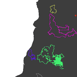
The dataset contains fire boundaries based on the MODIS dataset MCD64A1, computed using an algorithm analyzing the space-time relationship among burned area patches.
-
Each fire event in the dataset is assigned a unique identification number.
-
The dataset is available from 2001-01-01 to 2021-01-01 and is provided by the European Commission, Joint Research Centre, Global Wildfire Information System.
-
Key attributes for each fire include its area in square meters and its initial and final dates in milliseconds since 1970-01-01.
- Dataset Availability
- 2001-01-01T00:00:00Z–2021-01-01T00:00:00Z
- Dataset Producer
- European Commission, Joint Research Centre, Global Wildfire Information System
- Tags
Description
Fire boundaries based on the MODIS dataset MCD64A1. The data were computed based on an algorithm that relies on encoding in a graph structure a space-time relationship among patches of burned areas.
Each fire has a unique number identifying the event.
Table Schema
Table Schema
| Name | Type | Description |
|---|---|---|
| area | DOUBLE | Fire area, square meters |
| FinalDate | INT | Final fire date in milliseconds since 1970-01-01 |
| Id | INT | Numeric id of the fire |
| InitialDate | INT | Initial fire date in milliseconds since 1970-01-01 |
Terms of Use
Terms of Use
Citations
Artés, T., Oom, D., De Rigo, D., Durrant, T. H., Maianti, P., Libertà, G., & San-Miguel-Ayanz, J. (2019). A global wildfire dataset for the analysis of fire regimes and fire behaviour. Scientific data, 6(1), 1-11. doi:10.1038/s41597-019-0312-2
DOIs
Explore with Earth Engine
Code Editor (JavaScript)
var dataset = ee.FeatureCollection('JRC/GWIS/GlobFire/v2/FinalPerimeters');
var visParams = {
  palette: ['f5ff64', 'b5ffb4', 'beeaff', 'ffc0e8', '8e8dff', 'adadad'],
  min: 0,
  max: 600000000,
  opacity: 0.8,
};
var image = ee.Image().float().paint(dataset, 'area');
Map.addLayer(image, visParams, 'GlobFire Final');
Map.addLayer(dataset, null, 'for Inspector', false);
Map.setCenter(-122.121, 38.56, 12);