Page Summary
-
Global mangrove forest distribution data from 2000 was created using classified Landsat satellite images.
-
The JRC Yearly Water Classification History dataset provides maps and statistics of surface water location and temporal distribution from 1984 to 2021.
-
The MOD44B.061 Terra Vegetation Continuous Fields dataset offers a global, sub-pixel representation of surface vegetation cover as proportions of basic vegetation traits.
-
The Open Buildings Temporal V1 dataset contains annual data on building presence, fractional building counts, and heights at a 4m resolution from 2016-2023.
-
The Satellite Embedding V1 dataset is a global collection of learned 64-dimensional embedding vectors for each 10-meter pixel, encoding temporal surface conditions.
-
The VIIRS Nighttime Day/Night Annual Band Composites V2.1 and V2.2 datasets provide time series of global VIIRS nighttime lights data for different year ranges, produced from monthly cloud-free average radiance grids.
-
Global Annual Mangrove Extent (1984-2023)
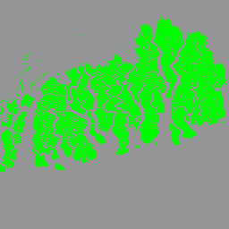
The CGMD-Extent30 (Continuous Global Mangrove Dynamics-Annual Mangrove Extent at 30-m resolution) dataset provides global annual mangrove extent from 1984 to 2023. The dataset is distributed as a single Earth Engine FeatureCollection, with each feature representing a mapped mangrove polygon for a specific year. The dataset … annual coastal forest-biomass global landsat-derived landuse-landcover -
Global Annual Mangrove Fractional Canopy Cover (1984-2023)
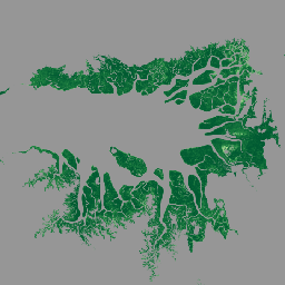
This dataset provides global annual mangrove fractional canopy cover (FCC) at 30-m spatial resolution from 1984 to 2023 to support large-scale analyses of long-term mangrove dynamics, including canopy degradation and recovery, blue carbon assessment, and coastal ecosystem monitoring. FCC quantifies the proportion of each Landsat … annual coastal forest-biomass global landsat-derived mangrove -
Global Mangrove Forests Distribution, v1 (2000)
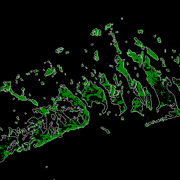
The database was prepared using Landsat satellite data from the year 2000. More than 1,000 Landsat scenes obtained from the USGS Earth Resources Observation and Science Center (EROS) were classified using hybrid supervised and unsupervised digital image classification techniques. This database is the first, most … annual ciesin forest-biomass global landsat-derived mangrove -
JRC Yearly Water Classification History, v1.4
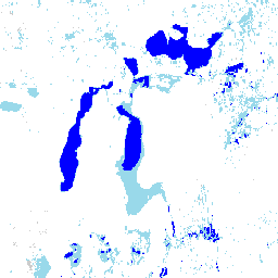
This dataset contains maps of the location and temporal distribution of surface water from 1984 to 2021 and provides statistics on the extent and change of those water surfaces. For more information see the associated journal article: High-resolution mapping of global surface water and its … annual geophysical google history jrc landsat-derived -
MOD44B.061 Terra Vegetation Continuous Fields Yearly Global 250m
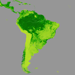
The Terra MODIS Vegetation Continuous Fields (VCF) product is a sub-pixel-level representation of surface vegetation cover estimates globally. Designed to continuously represent Earth's terrestrial surface as a proportion of basic vegetation traits, it provides a gradation of three surface cover components: percent tree cover, percent … annual geophysical global landuse-landcover modis nasa -
Open Buildings Temporal V1
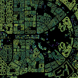
The Open Buildings 2.5D Temporal Dataset contains data about building presence, fractional building counts, and building heights at an effective1 spatial resolution of 4m (rasters are provided at 0.5m resolution) at an annual cadence from 2016-2023. It is produced from open-source, low-resolution imagery from the … africa annual asia built-up height open-buildings -
Satellite Embedding V1
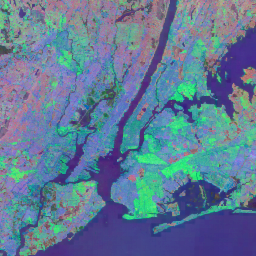
The Google Satellite Embedding dataset is a global, analysis-ready collection of learned geospatial embeddings. Each 10-meter pixel in this dataset is a 64-dimensional representation, or "embedding vector," that encodes temporal trajectories of surface conditions at and around that pixel as measured by various Earth observation … annual global google landsat-derived satellite-imagery sentinel1-derived -
VIIRS Nighttime Day/Night Annual Band Composites V2.1
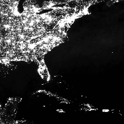
Annual global VIIRS nighttime lights dataset is a time series produced from monthly cloud-free average radiance grids spanning 2013 to 2021. Data for 2022 are available in the NOAA/VIIRS/DNB/ANNUAL_V22 dataset. An initial filtering step removed sunlit, moonlit and cloudy pixels, leading to rough composites that … annual dnb eog lights nighttime noaa -
VIIRS Nighttime Day/Night Annual Band Composites V2.2

Annual global VIIRS nighttime lights dataset is a time series produced from monthly cloud-free average radiance grids for 2022. Data for earlier years are available in the NOAA/VIIRS/DNB/ANNUAL_V21 dataset. An initial filtering step removed sunlit, moonlit and cloudy pixels, leading to rough composites that contains … annual dnb eog lights nighttime noaa