- Dataset Availability
- 1985-01-01T00:00:00Z–2020-12-31T00:00:00Z
- Dataset Provider
- United States Geological Survey and Bureau of Land Management
- Earth Engine Snippet
-
ee.ImageCollection("USGS/NLCD_RELEASES/2019_REL/RCMAP/V4/COVER") - Tags
Description
Rangeland ecosystems in the western United States have a dynamic response to climate change, fire, and other anthropogenic disturbances. The Rangeland Condition, Monitoring, Assessment, and Projection (RCMAP) product aims to capture this response by quantifying the percent cover of rangeland components, associated error, and trends across the western U.S. using Landsat imagery from 1985-2020.
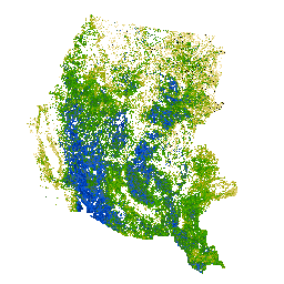
RCMAP quantifies the percent cover of components across the western U.S. rangelands (after Rigge et al. 2020) using Landsat imagery from 1985-2020. The RCMAP timeseries consists of eight fractional components: annual herbaceous, bare ground, herbaceous, litter, non-sagebrush shrub, perennial herbaceous, sagebrush and shrub, and the temporal trends of each. The four primary components (bare ground, shrub, litter, and herbaceous) are designed to sum to 100% in each pixel when added to tree canopy cover. The secondary components annual herbaceous and perennial herbaceous are subsets of the primary component herbaceous, while non-sagebrush shrub and sagebrush are subsets of shrub. Secondary components cannot have cover greater than their respective primary component. One year, 2012, was excluded from the timeseries due to a lack of quality imagery.
MRLC developed an automated method to identify change in spectral conditions between each year in the Landsat archive and the circa 2016 base map. Regression tree models were trained from the unchanged portions of each year in the time series. Post-processing models corrected post-burn trajectories and eliminated noise and illogical change in the predictions. The current generation of RCMAP has been improved with more training data, regional-scale Landsat composites, and more robust change detection. MRLC assessed the temporal patterns in each component with a linear model and structural change method which determines break points in the timeseries using an 8-year temporal moving window. The linear and structural change methods generally agreed on gross patterns of change, but the latter found breaks more often with most pixels having at least one break point. Data provide spatiotemporal information on the occurrence of breaks, but even more critically, attribute those change events to specific component(s). The spatially, temporally, and thematically (i.e., multi-component) detailed specific information on rangeland condition can contribute to understanding major patterns of change at local, regional, and continental levels.
See also:
Rigge, M., C. Homer, L. Cleeves, D. K. Meyer, B. Bunde, H. Shi, G. Xian, S. Schell, and M. Bobo. 2020. Quantifying western U.S. rangelands as fractional components with multi-resolution remote sensing and in situ data. Remote Sensing 12. doi:10.3390/rs12030412
Rigge, M., C. Homer, H. Shi, D. Meyer, B. Bunde, B. Granneman, K. Postma, P. Danielson, A. Case, and G. Xian. 2021. Rangeland Fractional Components Across the Western United States from 1985 to 2018. Remote Sensing 13:813. doi:10.3390/rs13040813
Bands
Resolution
30 meters
Bands
| Name | Units | Min | Max | Description |
|---|---|---|---|---|
rangeland_annual_herbaceous |
% | 0 | 100 | Percent of the pixel covered by annual herbaceous vegetation. |
rangeland_bare_ground |
% | 0 | 100 | Percent of the pixel covered by bare ground. |
rangeland_non_sagebrush_shrub |
% | 0 | 100 | Percent of the pixel covered by non-sagebrush shrubs. |
rangeland_herbaceous |
% | 0 | 100 | Percent of the pixel covered by herbaceous vegetation. |
rangeland_litter |
% | 0 | 100 | Percent of the pixel covered by litter. |
rangeland_sagebrush |
% | 0 | 100 | Percent of the pixel covered by sagebrush (Artemisia spp). |
rangeland_shrub |
% | 0 | 100 | Percent of the pixel covered by shrub. |
rangeland_perennial_herbaceous |
% | 0 | 100 | Percent of the pixel covered by perennial herbaceous vegetation. |
Terms of Use
Terms of Use
This work was authored as part of the Contributor's official duties as an Employee of the United States Government and is therefore a work of the United States Government. In accordance with 17 U.S.C. 105, no copyright protection is available for such works under U.S. Law. This is an Open Access article that has been identified as being free of known restrictions under copyright law, including all related and neighboring rights (https://creativecommons.org/publicdomain/mark/1.0/). You can copy, modify, distribute and perform the work, even for commercial purposes, all without asking permission.
Citations
Rigge, M.B., Bunde, B., Shi, H., Postma, K., 2021, Rangeland Condition Monitoring Assessment and Projection (RCMAP) Fractional Component Time-Series Across the Western U.S. 1985-2020 (ver. 2.0, October 2021): U.S. Geological Survey data release. doi:10.5066/P95IQ4BT
Explore with Earth Engine
Code Editor (JavaScript)
// Import the NLCD RCMAP collection.
var dataset = ee.ImageCollection('USGS/NLCD_RELEASES/2019_REL/RCMAP/V4/COVER');

// Filter the collection to the 2016 product.
var rcmap2016 = dataset.filter(ee.Filter.eq('system:index', '2016')).first();

// Each product has multiple bands for different rangeland categories.
print('Bands:', rcmap2016.bandNames());

// Select the rangeland_annual_herbaceous band.
var landcover = rcmap2016.select('rangeland_annual_herbaceous');

var vis = {
  'palette': [
      '000000', 'f9e8b7', 'f7e3ac', 'f0dfa3', 'eedf9c', 'eada91', 'e8d687', 'e0d281', 'ddd077', 'd6cc6d',
      'd3c667', 'd0c55e', 'cfc555', 'c6bd4f', 'c4ba46', 'bdb83a', 'bbb534', 'b7b02c', 'b0ad1f', 'adac17',
      'aaaa0a', 'a3a700', '9fa700', '9aa700', '92a700', '8fa700', '87a700', '85a700', '82aa00', '7aaa00',
      '77aa00', '70aa00', '6caa00', '67aa00', '5fa700', '57a700', '52a700', '4fa700', '4aa700', '42a700',
      '3ca700', '37a700', '37a300', '36a000', '369f00', '349d00', '339900', '339900', '2f9200', '2d9100',
      '2d8f00', '2c8a00', '2c8800', '2c8500', '2c8400', '2b8200', '297d00', '297a00', '297900', '277700',
      '247400', '247000', '29700f', '2c6d1c', '2d6d24', '336d2d', '366c39', '376c44', '396a4a', '396a55',
      '3a6a5f', '3a696a', '396774', '3a6782', '39668a', '376292', '34629f', '2f62ac', '2c5fb7', '245ec4',
      '1e5ed0', '115cdd', '005ae0', '0057dd', '0152d6', '0151d0', '014fcc', '014ac4', '0147bd', '0144b8',
      '0142b0', '0141ac', '013da7', '013aa0', '01399d', '013693', '013491', '012f8a', '012d85', '012c82', '01297a',
  ]
};

// Display land cover on the map.
Map.setCenter(-114, 38, 6);
Map.addLayer(landcover, vis, 'Rangeland Annual Herbaceous %');