Page Summary
-
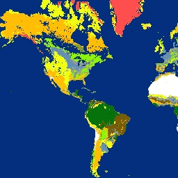
This dataset, derived from the MODIS MCD12Q1 product, provides fractional landcover data at 5km resolution.
-
It offers percentage coverage for 17 landcover classes, including an overall dominant class.
-
The data is available annually from 2001 to 2013.
-
This product was created by the Malaria Atlas Project at the University of Oxford.
- Dataset Availability
- 2001-01-01T00:00:00Z–2013-01-01T00:00:00Z
- Dataset Producer
- Oxford Malaria Atlas Project
- Cadence
- 1 Year
- Tags
Description
The underlying dataset for this landcover product is the IGBP layer found within the MODIS annual landcover product (MCD12Q1). This data was converted from its categorical format, which has a ≈500 meter resolution, to a fractional product indicating the integer percentage (0-100) of the output pixel covered by each of the 17 landcover classes (1 per band).
This dataset was produced by Harry Gibson and Daniel Weiss of the Malaria Atlas Project (Big Data Institute, University of Oxford, United Kingdom, https://malariaatlas.org/).
Bands
Bands
Pixel size: 5000 meters (all bands)
| Name | Units | Min | Max | Pixel Size | Description |
|---|---|---|---|---|---|
Overall_Class |
0 | 17 | 5000 meters | Dominant class of each resulting pixel |
|
Water |
% | 0 | 100 | 5000 meters | Percentage of water |
Evergreen_Needleleaf_Forest |
% | 0 | 100 | 5000 meters | Percentage of evergreen needleleaf forest |
Evergreen_Broadleaf_Forest |
% | 0 | 100 | 5000 meters | Percentage of evergreen broadleaf forest |
Deciduous_Needleleaf_Forest |
% | 0 | 100 | 5000 meters | Percentage of deciduous needleleaf forest |
Deciduous_Broadleaf_Forest |
% | 0 | 100 | 5000 meters | Percentage of deciduous broadleaf forest |
Mixed_Forest |
% | 0 | 100 | 5000 meters | Percentage of mixed forest |
Closed_Shrublands |
% | 0 | 100 | 5000 meters | Percentage of closed shrublands |
Open_Shrublands |
% | 0 | 100 | 5000 meters | Percentage of open shrublands |
Woody_Savannas |
% | 0 | 100 | 5000 meters | Percentage of woody savannas |
Savannas |
% | 0 | 100 | 5000 meters | Percentage of savannas |
Grasslands |
% | 0 | 100 | 5000 meters | Percentage of grasslands |
Permanent_Wetlands |
% | 0 | 100 | 5000 meters | Percentage of permanent wetlands |
Croplands |
% | 0 | 100 | 5000 meters | Percentage of croplands |
Urban_And_Built_Up |
% | 0 | 100 | 5000 meters | Percentage of urban and built up |
Cropland_Natural_Vegetation_Mosaic |
% | 0 | 100 | 5000 meters | Percentage of cropland natural vegetation mosaic |
Snow_And_Ice |
% | 0 | 100 | 5000 meters | Percentage of snow and ice |
Barren_Or_Sparsely_Populated |
% | 0 | 100 | 5000 meters | Percentage of barren or sparsely populated |
Unclassified |
% | 0 | 100 | 5000 meters | Percentage of unclassified |
No_Data |
% | 0 | 100 | 5000 meters | Percentage of no data |
Overall_Class Class Table
| Value | Color | Description |
|---|---|---|
| 0 | #032f7e | Water |
| 1 | #02740b | Evergreen_Needleleaf_Fores |
| 2 | #02740b | Evergreen_Broadleaf_Forest |
| 3 | #8cf502 | Deciduous_Needleleaf_Forest |
| 4 | #8cf502 | Deciduous_Broadleaf_Forest |
| 5 | #a4da01 | Mixed_Forest |
| 6 | #ffbd05 | Closed_Shrublands |
| 7 | #ffbd05 | Open_Shrublands |
| 8 | #7a5a02 | Woody_Savannas |
| 9 | #f0ff0f | Savannas |
| 10 | #869b36 | Grasslands |
| 11 | #6091b4 | Permanent_Wetlands |
| 12 | #ff4e4e | Croplands |
| 13 | #999999 | Urban_and_Built-up |
| 14 | #ff4e4e | Cropland_Natural_Vegetation_Mosaic |
| 15 | #ffffff | Snow_and_Ice |
| 16 | #feffc0 | Barren_Or_Sparsely_Vegetated |
| 17 | #020202 | Unclassified |
Terms of Use
Terms of Use
Citations
Weiss, D.J., P.M. Atkinson, S. Bhatt, B. Mappin, S.I. Hay & P.W. Gething (2014) An effective approach for gap-filling continental scale remotely sensed time-series. ISPRS Journal of Photogrammetry and Remote Sensing, 98, 106-118.
Explore with Earth Engine
Code Editor (JavaScript)
var dataset =
    ee.ImageCollection('Oxford/MAP/IGBP_Fractional_Landcover_5km_Annual')
        .filter(ee.Filter.date('2012-01-01', '2012-12-31'));
var landcover = dataset.select('Overall_Class');
var landcoverVis = {
  min: 1.0,
  max: 19.0,
  palette: [
    '032f7e', '02740b', '02740b', '8cf502', '8cf502', 'a4da01', 'ffbd05',
    'ffbd05', '7a5a02', 'f0ff0f', '869b36', '6091b4', '999999', 'ff4e4e',
    'ff4e4e', 'ffffff', 'feffc0', '020202', '020202'
  ],
};
Map.setCenter(-88.6, 26.4, 1);
Map.addLayer(landcover, landcoverVis, 'Landcover');