Page Summary
-
The dataset provides 8-day composite surface reflectance estimates from the Suomi NPP VIIRS sensor at nominal 500m resolution.
-
Data is available from 2012-01-19 to 2025-09-30 and is corrected for atmospheric conditions.
-
Each pixel represents the best possible Level 2G observation over an 8-day period, selected based on quality criteria like cloud absence and sensor angle.
-
The product includes three reflectance bands (I1, I2, I3) along with state quality assurance and reflectance band quality layers.
-
LP DAAC NASA data is freely accessible, with a request for citation when used in publications.
- Dataset Availability
- 2012-01-19T00:00:00Z–2026-07-04T00:00:00Z
- Dataset Producer
- NASA LP DAAC at the USGS EROS Center
- Cadence
- 1 Day
- Tags
Description
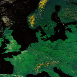
The 8-day Visible Infrared Imaging Radiometer Suite (VIIRS) Surface Reflectance (VNP09H1) Version 1 composite product provides an estimate of land surface reflectance from the Suomi National Polar-orbiting Partnership (Suomi NPP) VIIRS sensor for three imagery bands (I1, I2, I3) at nominal 500m resolution (~463m). The 500m dataset is derived through resampling the native 375m VIIRS resolution in the L2 input product. The data are corrected for atmospheric conditions such as the effects of molecular gases, including ozone and water vapor, and for the effects of atmospheric aerosols. Each pixel represents the best possible Level 2G observation during an 8-day period, which is selected on the basis of high observation coverage, low sensor angle, the absence of clouds or cloud shadow, and aerosol loading. The three reflectance bands, this product includes a state quality assurance (QA) layer and a reflectance band quality layer.
Documentation:
Bands
Bands
Pixel size: 500 meters (all bands)
| Name | Min | Max | Pixel Size | Description | |||||||||||||||||||||||||||||||||||||||||||||||||||||||||||||||||||||||||||||||||||||||||||||||
|---|---|---|---|---|---|---|---|---|---|---|---|---|---|---|---|---|---|---|---|---|---|---|---|---|---|---|---|---|---|---|---|---|---|---|---|---|---|---|---|---|---|---|---|---|---|---|---|---|---|---|---|---|---|---|---|---|---|---|---|---|---|---|---|---|---|---|---|---|---|---|---|---|---|---|---|---|---|---|---|---|---|---|---|---|---|---|---|---|---|---|---|---|---|---|---|---|---|---|---|
SurfReflect_I1 |
-100 | 16000 | 500 meters | 500 m Surface Reflectance Band I1 |
|||||||||||||||||||||||||||||||||||||||||||||||||||||||||||||||||||||||||||||||||||||||||||||||
SurfReflect_I2 |
-100 | 16000 | 500 meters | 500 m Surface Reflectance Band I2 |
|||||||||||||||||||||||||||||||||||||||||||||||||||||||||||||||||||||||||||||||||||||||||||||||
SurfReflect_I3 |
-100 | 16000 | 500 meters | 500 m Surface Reflectance Band I3 |
|||||||||||||||||||||||||||||||||||||||||||||||||||||||||||||||||||||||||||||||||||||||||||||||
SurfReflect_QC_500m |
500 meters | Surface Reflectance Band Quality Control (QC) |
|||||||||||||||||||||||||||||||||||||||||||||||||||||||||||||||||||||||||||||||||||||||||||||||||
SurfReflect_State_500m |
500 meters | Surface Reflectance State Quality Assurance (QA) |
|||||||||||||||||||||||||||||||||||||||||||||||||||||||||||||||||||||||||||||||||||||||||||||||||
Terms of Use
Terms of Use
LP DAAC NASA data are freely accessible; however, when an author publishes these data or works based on the data, it is requested that the author cite the datasets within the text of the publication and include a reference to them in the reference list.
Citations
Please visit LP DAAC 'Citing Our Data' page
DOIs
Explore with Earth Engine
Code Editor (JavaScript)
var dataset = ee.ImageCollection('NASA/VIIRS/002/VNP09H1')
                  .filter(ee.Filter.date('2017-05-01', '2017-06-30'));
var rgb = dataset.select(['SurfReflect_I1', 'SurfReflect_I2', 'SurfReflect_I3']);
var rgbVis = {
  min: 0.0,
  max: 1.0,
};
Map.setCenter(17.93, 7.71, 2);
Map.addLayer(rgb, rgbVis, 'RGB');