Page Summary
-
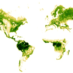
This dataset provides global tree height information based on 2005 spaceborne-lidar data fused with ancillary geospatial data.
-
The data was collected between May 20 and June 23, 2005, and is provided by NASA/JPL.
-
The dataset includes one band representing tree heights in meters, with a pixel size of 927.67 meters.
-
Materials published on the Earth Observatory, including this dataset, are generally available for re-use with credit to NASA.
-
The dataset can be explored using Google Earth Engine for scientific analysis and visualization.
- Dataset Availability
- 2005-05-20T00:00:00Z–2005-06-23T00:00:00Z
- Dataset Producer
- NASA/JPL
- Tags
Description
This dataset represents global tree heights based on a fusion of spaceborne-lidar data (2005) from the Geoscience Laser Altimeter System (GLAS) and ancillary geospatial data. See Simard et al. (2011) for details.
Bands
Bands
Pixel size: 927.67 meters (all bands)
| Name | Units | Min | Max | Pixel Size | Description |
|---|---|---|---|---|---|
1 |
m | 0* | 73* | 927.67 meters | Tree heights |
Terms of Use
Terms of Use
Most materials published on the Earth Observatory, including images, are freely available for re-publication or re-use, including commercial purposes, except for where copyright is indicated.
NASA's Earth Observatory must be given credit for its original materials; the only mandatory credit is NASA.
For more information about using NASA imagery visit the Earth Observatory Image Use Policy site.
Citations
Simard, M., Pinto, N., Fisher, J., Baccini, A. 2011. Mapping forest canopy height globally with spaceborne lidar. Journal of Geophysical Research. 116: G04021. doi:10.1029/2011JG001708
Explore with Earth Engine
Code Editor (JavaScript)
var dataset = ee.Image('NASA/JPL/global_forest_canopy_height_2005');
var forestCanopyHeight = dataset.select('1');
var forestCanopyHeightVis = {
  min: 0.0,
  max: 30.0,
  palette: [
    'ffffff', 'fcd163', '99b718', '66a000', '3e8601', '207401', '056201',
    '004c00', '011301'
  ],
};
Map.setCenter(-28.1, 28.3, 1);
Map.addLayer(forestCanopyHeight, forestCanopyHeightVis, 'Forest Canopy Height');