Page Summary
-
The MCD15A3H Version 6.1 MODIS dataset provides 4-day composite data of Fraction of Photosynthetically Active Radiation (FPAR) and Leaf Area Index (LAI) at a 500-meter pixel size.
-
Data is available from 2002-07-04 to 2025-10-08 and is provided by NASA LP DAAC at the USGS EROS Center.
-
The dataset includes bands for FPAR, LAI, and associated quality control information.
-
MODIS data and products have no restrictions on subsequent use, sale, or redistribution.
- Dataset Availability
- 2002-07-04T00:00:00Z–2026-07-16T00:00:00Z
- Dataset Producer
- NASA LP DAAC at the USGS EROS Center
- Cadence
- 4 Days
- Tags
Description
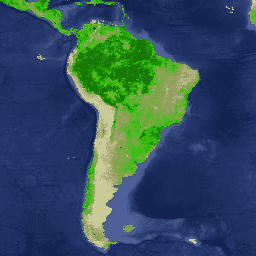
The MCD15A3H Version 6.1 Moderate Resolution Imaging Spectroradiometer (MODIS) Level 4, Combined Fraction of Photosynthetically Active Radiation (FPAR), and Leaf Area Index (LAI) product is a 4-day composite data set with 500 meter pixel size. The algorithm chooses the best pixel available from all the acquisitions of both MODIS sensors located on NASA's Terra and Aqua satellites from within the 4-day period.
Documentation:
Bands
Bands
Pixel size: 500 meters (all bands)
| Name | Min | Max | Scale | Pixel Size | Wavelength | Description | |||||||||||||||||||||||||||||||||||||||||||||||||||||||||||||||||||||||||||||||||||||||||||||
|---|---|---|---|---|---|---|---|---|---|---|---|---|---|---|---|---|---|---|---|---|---|---|---|---|---|---|---|---|---|---|---|---|---|---|---|---|---|---|---|---|---|---|---|---|---|---|---|---|---|---|---|---|---|---|---|---|---|---|---|---|---|---|---|---|---|---|---|---|---|---|---|---|---|---|---|---|---|---|---|---|---|---|---|---|---|---|---|---|---|---|---|---|---|---|---|---|---|---|---|
Fpar |
0 | 100 | 0.01 | 500 meters | 400-700nm | FPAR absorbed by the green elements of a vegetation canopy |
|||||||||||||||||||||||||||||||||||||||||||||||||||||||||||||||||||||||||||||||||||||||||||||
Lai |
0 | 100 | 0.1 | 500 meters | None | One-sided green leaf area per unit ground area in broadleaf canopies; one-half the total needle surface area per unit ground area in coniferous canopies |
|||||||||||||||||||||||||||||||||||||||||||||||||||||||||||||||||||||||||||||||||||||||||||||
FparLai_QC |
500 meters | None | Quality for Lai and Fpar |
||||||||||||||||||||||||||||||||||||||||||||||||||||||||||||||||||||||||||||||||||||||||||||||||
FparExtra_QC |
500 meters | None | Extra detail quality for LAI and FPAR |
||||||||||||||||||||||||||||||||||||||||||||||||||||||||||||||||||||||||||||||||||||||||||||||||
FparStdDev |
0 | 100 | 0.01 | 500 meters | None | Standard deviation of Fpar |
|||||||||||||||||||||||||||||||||||||||||||||||||||||||||||||||||||||||||||||||||||||||||||||
LaiStdDev |
0 | 100 | 0.1 | 500 meters | None | Standard deviation for Lai |
|||||||||||||||||||||||||||||||||||||||||||||||||||||||||||||||||||||||||||||||||||||||||||||
Terms of Use
Terms of Use
MODIS data and products acquired through the LP DAAC have no restrictions on subsequent use, sale, or redistribution.
Citations
Please visit LP DAAC 'Citing Our Data' page for information on citing LP DAAC datasets.
DOIs
Explore with Earth Engine
Code Editor (JavaScript)
var dataset = ee.ImageCollection('MODIS/061/MCD15A3H');
var defaultVisualization = dataset.first().select('Fpar');
var defaultVisualizationVis = {
  min: 0.0,
  max: 100.0,
  palette: ['e1e4b4', '999d60', '2ec409', '0a4b06'],
};
Map.setCenter(6.746, 46.529, 6);
Map.addLayer(
    defaultVisualization, defaultVisualizationVis, 'Default visualization');
import ee
import geemap.core as geemap
Colab (Python)
dataset = ee.ImageCollection('MODIS/061/MCD15A3H')

default_visualization = dataset.first().select('Fpar')

default_visualization_vis = {
    'min': 0.0,
    'max': 100.0,
    'palette': ['e1e4b4', '999d60', '2ec409', '0a4b06'],
}

m = geemap.Map()
m.set_center(6.746, 46.529, 6)
m.add_layer(
    default_visualization, default_visualization_vis, 'Default visualization'
)
m