Page Summary
-
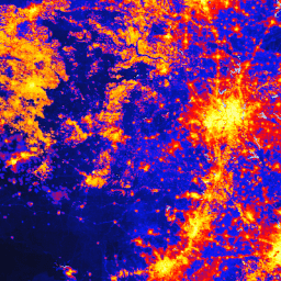
The global Human Modification dataset (gHM) provides a cumulative measure of human modification of terrestrial lands globally at 1 square-kilometer resolution.
-
gHM values range from 0.0 to 1.0, reflecting the proportion and intensity of modification at a given location.
-
The dataset maps 5 major anthropogenic stressors from 2016 using 13 individual datasets, including human settlement, agriculture, transportation, mining/energy, and electrical infrastructure.
-
The dataset is available for the year 2016 with a cadence of 1 year.
-
The data is licensed under CC-BY-NC-SA-4.0 and should be cited using the provided paper.
- Dataset Availability
- 2016-01-01T00:00:00Z–2016-12-31T00:00:00Z
- Dataset Producer
- Conservation Science Partners
- Cadence
- 1 Year
- Tags
Description
The global Human Modification dataset (gHM) provides a cumulative measure of human modification of terrestrial lands globally at 1 square-kilometer resolution. The gHM values range from 0.0-1.0 and are calculated by estimating the proportion of a given location (pixel) that is modified, the estimated intensity of modification associated with a given type of human modification or "stressor". 5 major anthropogenic stressors circa 2016 were mapped using 13 individual datasets:
- human settlement (population density, built-up areas)
- agriculture (cropland, livestock)
- transportation (major, minor, and two-track roads; railroads)
- mining and energy production
- electrical infrastructure (power lines, nighttime lights)
Please see the paper for additional methodological details. This asset was re-projected to WGS84 for use in Earth Engine.
Bands
Bands
Pixel size: 1000 meters (all bands)
| Name | Units | Min | Max | Pixel Size | Description |
|---|---|---|---|---|---|
gHM |
km^2 | 0 | 1 | 1000 meters | global Human Modification |
Terms of Use
Terms of Use
Citations
Kennedy, C.M., J.R. Oakleaf, D.M. Theobald, S. Baruch-Murdo, and J. Kiesecker. 2019. Managing the middle: A shift in conservation priorities based on the global human modification gradient. Global Change Biology 00:1-16. doi:10.1111/gcb.14549
Explore with Earth Engine
Code Editor (JavaScript)
var dataset = ee.ImageCollection('CSP/HM/GlobalHumanModification');

var visualization = {
  bands: ['gHM'],
  min: 0.0,
  max: 1.0,
  palette: ['0c0c0c', '071aff', 'ff0000', 'ffbd03', 'fbff05', 'fffdfd']
};

Map.centerObject(dataset);

Map.addLayer(dataset, visualization, 'Human modification');