Page Summary
-
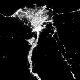
The Consistent and Corrected Nighttime Lights (CCNL) dataset is a reprocessed version of the DMSP Operational Line-Scan System (OLS) data, improved to mitigate inconsistencies and effects like saturation and blooming.
-
CCNL Version 1 provides global coverage from 75N to 65S with a 1 km pixel size.
-
The dataset is available yearly from 1992 to 2014.
-
The dataset has one band representing corrected nighttime light intensity.
-
The dataset is provided by Beijing Normal University and is available under a CC-BY-4.0 license.
- Dataset Availability
- 1992-01-01T00:00:00Z–2014-01-01T00:00:00Z
- Dataset Producer
- Beijing Normal University
- Cadence
- 1 Year
- Tags
Description
The Consistent and Corrected Nighttime Lights (CCNL) dataset is a reprocessed version of the Defense Meteorological Program (DMSP) Operational Line-Scan System (OLS) Version 4. A series of methods was used to mitigate the impact of inter-annual inconsistency, saturation, and blooming effects and to improve data quality.
CCNL Version 1 spans the globe from 75N to 65S and has 1 km pixel size.
Bands
Bands
Pixel size: 1000 meters (all bands)
| Name | Pixel Size | Description |
|---|---|---|
b1 |
1000 meters | Corrected nighttime light intensity. |
Terms of Use
Terms of Use
Citations
Zhao,Chenchen, Cao,Xin, Chen,Xuehong, & Cui,Xihong. (2020). A Consistent and Corrected Nighttime Light dataset (CCNL 1992-2013) from DMSP-OLS data (Version 1.0) [Data set]. Zenodo. https://doi.org/10.5281/zenodo.6644980
Explore with Earth Engine
Code Editor (JavaScript)
var dataset = ee.ImageCollection('BNU/FGS/CCNL/v1')
                  .filter(ee.Filter.date('2010-01-01', '2010-12-31'));
var nighttimeLights = dataset.select('b1');
var nighttimeLightsVis = {
  min: 3.0,
  max: 60.0,
};
Map.setCenter(31.4, 30, 6);
Map.addLayer(nighttimeLights, nighttimeLightsVis, 'Nighttime Lights');