Page Summary
-
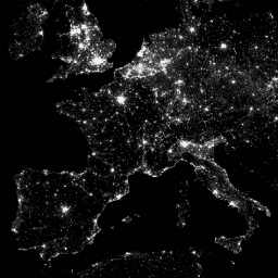
The Defense Meteorological Program (DMSP) Operational Line-Scan System (OLS) dataset provides nighttime visible and near-infrared emission data from 1992 to 2014.
-
Version 4 consists of cloud-free composites of archived DMSP-OLS data, including bands for average visible light, stable lights, cloud-free coverage, and average lights multiplied by percent detection frequency.
-
The data is provided by the Earth Observation Group at the Colorado School of Mines and processed by NOAA's National Geophysical Data Center.
-
This public domain dataset can be used for any lawful purpose and is available for exploration and analysis through the Google Earth Engine platform.
- Dataset Availability
- 1992-01-01T00:00:00Z–2014-01-01T00:00:00Z
- Dataset Producer
- Earth Observation Group, Payne Institute for Public Policy, Colorado School of Mines
- Tags
Description
The Defense Meteorological Program (DMSP) Operational Line-Scan System (OLS) has a unique capability to detect visible and near-infrared (VNIR) emission sources at night.
Version 4 of the DMSP-OLS Nighttime Lights Time Series consists of cloud-free composites made using all the available archived DMSP-OLS smooth resolution data for calendar years. In cases where two satellites were collecting data, two composites were produced.
Image and data processing by NOAA's National Geophysical Data Center. DMSP data collected by US Air Force Weather Agency.
Bands
Bands
Pixel size: 927.67 meters (all bands)
| Name | Min | Max | Pixel Size | Description |
|---|---|---|---|---|
avg_vis |
0* | 63* | 927.67 meters | The average of the visible band digital number values with no further filtering. |
stable_lights |
0* | 63* | 927.67 meters | The cleaned up avg_vis contains the lights from cities, towns, and other sites with persistent lighting, including gas flares. Ephemeral events, such as fires, have been discarded. The background noise was identified and replaced with values of zero. |
cf_cvg |
0* | 126* | 927.67 meters | Cloud-free coverages tally the total number of observations that went into each 30-arc second grid cell. This band can be used to identify areas with low numbers of observations where the quality is reduced. |
avg_lights_x_pct |
0* | 63* | 927.67 meters | The average visible band digital number (DN) of cloud-free light detections multiplied by the percent frequency of light detection. The inclusion of the percent frequency of detection term normalizes the resulting digital values for variations in the persistence of lighting. For instance, the value for a light only detected half the time is discounted by 50%. Note that this product contains detections from fires and a variable amount of background noise. |
Terms of Use
Terms of Use
NOAA data, information, and products, regardless of the method of delivery, are not subject to copyright and carry no restrictions on their subsequent use by the public. Once obtained, they may be put to any lawful use. The forgoing data is in the public domain and is being provided without restriction on use and distribution.
Explore with Earth Engine
Code Editor (JavaScript)
var dataset = ee.ImageCollection('NOAA/DMSP-OLS/NIGHTTIME_LIGHTS')
                  .filter(ee.Filter.date('2010-01-01', '2010-12-31'));
var nighttimeLights = dataset.select('avg_vis');
var nighttimeLightsVis = {
  min: 3.0,
  max: 60.0,
};
Map.setCenter(7.82, 49.1, 4);
Map.addLayer(nighttimeLights, nighttimeLightsVis, 'Nighttime Lights');
import ee
import geemap.core as geemap
Colab (Python)
dataset = ee.ImageCollection('NOAA/DMSP-OLS/NIGHTTIME_LIGHTS').filter(
    ee.Filter.date('2010-01-01', '2010-12-31')
)

nighttime_lights = dataset.select('avg_vis')

nighttime_lights_vis = {'min': 3.0, 'max': 60.0}

m = geemap.Map()
m.set_center(7.82, 49.1, 4)
m.add_layer(nighttime_lights, nighttime_lights_vis, 'Nighttime Lights')
m