Page Summary
-
MERIT Hydro provides global hydrography datasets including a flow direction map at 3 arc-second resolution derived from MERIT DEM and water body datasets.
-
Supplementary visualization layers are available for MERIT Hydro.
-
MERIT Hydro: Global Hydrography Datasets
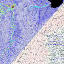
MERIT Hydro is a new global flow direction map at 3 arc-second resolution (~90 m at the equator) derived from the version 1.0.3 of the MERIT DEM elevation data and water body datasets (G1WBM, GSWO and OpenStreetMap). MERIT Hydro contains the output of a new … dem elevation hydrography hydrosheds merit river-width -
MERIT Hydro: Supplementary Visualization Layers

Supplementary visualization layers for MERIT Hydro hydrography hydrosheds merit river-width surface-ground-water upstream-drainage-area