Page Summary
-
Land Data Assimilation System (LDAS) combines various observations to estimate near-surface climatological properties.
-
NASA Global Land Data Assimilation System Version 2 (GLDAS-2) includes three components: GLDAS-2.0, GLDAS-2.1, and GLDAS-2.2.
-
GLDAS-2.0 provides a temporally consistent series from 1948 through 2014 forced by Princeton meteorological data.
-
NLDAS-2 is the primary forcing file for the North American Land Data Assimilation System.
-
GLDAS-2.1: Global Land Data Assimilation System
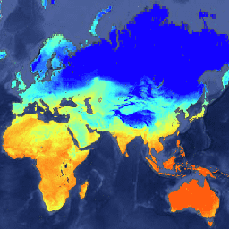
NASA Global Land Data Assimilation System Version 2 (GLDAS-2) has three components: GLDAS-2.0, GLDAS-2.1, and GLDAS-2.2. GLDAS-2.0 is forced entirely with the Princeton meteorological forcing input data and provides a temporally consistent series from 1948 through 2014. GLDAS-2.1 is forced with a combination of model … 3-hourly climate cryosphere evaporation forcing geophysical -
GLDAS-2.2: Global Land Data Assimilation System

NASA Global Land Data Assimilation System Version 2 (GLDAS-2) has three components: GLDAS-2.0, GLDAS-2.1, and GLDAS-2.2. GLDAS-2.0 is forced entirely with the Princeton meteorological forcing input data and provides a temporally consistent series from 1948 through 2014. GLDAS-2.1 is forced with a combination of model … 3-hourly climate cryosphere evaporation forcing geophysical -
NLDAS-2: North American Land Data Assimilation System Forcing Fields
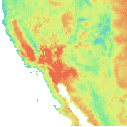
Land Data Assimilation System (LDAS) combines multiple sources of observations (such as precipitation gauge data, satellite data, and radar precipitation measurements) to produce estimates of climatological properties at or near the Earth''s surface. This dataset is the primary (default) forcing file (File A) for Phase … climate evaporation forcing geophysical hourly humidity -
Reprocessed GLDAS-2.0: Global Land Data Assimilation System

NASA Global Land Data Assimilation System Version 2 (GLDAS-2) has three components: GLDAS-2.0, GLDAS-2.1, and GLDAS-2.2. GLDAS-2.0 is forced entirely with the Princeton meteorological forcing input data and provides a temporally consistent series from 1948 through 2014. GLDAS-2.1 is forced with a combination of model … 3-hourly climate cryosphere evaporation forcing geophysical