Page Summary
-
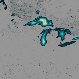
The GLObal Bathymetric (GLOBathy) dataset provides detailed bathymetry for over 1.4 million waterbodies globally.
-
GLOBathy was developed using a GIS-based framework integrating data from the HydroLAKES dataset.
-
The dataset has a pixel size of 30 meters with a band representing maximum depth.
-
The GLOBathy dataset is released under an assumed CC0 1.0 Universal Public Domain Dedication.
-
This dataset is part of the Community Catalog and is not managed by Google Earth Engine.
- Catalog Owner
- Awesome GEE Community Catalog
- Dataset Availability
- 2022-01-26T00:00:00Z–2022-01-26T23:59:00Z
- Dataset Producer
- Bahram Khazaei
- Tags
Description
The GLObal Bathymetric (GLOBathy) dataset, comprising data on over 1.4 million waterbodies globally, has been meticulously developed to harmonize with the widely recognized HydroLAKES dataset. Utilizing a sophisticated Geographic Information System (GIS)-based framework, GLOBathy constructs detailed bathymetric maps by integrating maximum depth estimates and geometric/geophysical attributes sourced from HydroLAKES. Ensuring data accuracy and reliability, GLOBathy undergoes stringent validation procedures involving 1,503 waterbodies and a diverse range of observed data sources. Consequently, GLOBathy stands as a robust and comprehensive dataset for hydrography and aquatic sciences, offering invaluable resources for researchers and professionals in these fields.
Bands
Bands
Pixel size: 30 meters (all bands)
| Name | Units | Min | Max | Pixel Size | Description |
|---|---|---|---|---|---|
b1 |
m | 0* | 1548.53* | 30 meters | Maximum depth |
Terms of Use
Terms of Use
The dataset is released under an assumed CC0 1.0 Universal (CC0 1.0) Public Domain Dedication. The organizations responsible for generating and funding this dataset make no representations of any kind including, but not limited to the warranties of merchantability or fitness for a particular use, nor are any such warranties to be implied with respect to the data.
Citations
Khazaei, Bahram; Read, Laura K; Casali, Matthew; Sampson, Kevin M; Yates, David N (2022): GLOBathy Bathymetry Rasters. figshare. Dataset. https://doi.org/10.6084/m9.figshare.c.5243309.v1
DOIs
Explore with Earth Engine
Code Editor (JavaScript)
var globathy = ee.Image(
  "projects/sat-io/open-datasets/GLOBathy/GLOBathy_bathymetry"
);

var palettes = require("users/samapriya/utils:palettes");

// Use these visualization parameters, customized by location.
var visParams = { min: 1, max: 700, palette: palettes.extra.blkred };

// Note that the visualization image doesn't require visualization parameters.
Map.addLayer(globathy, visParams, "Globathy Bathymetry (m)");