Page Summary
-
The HydroSHEDS mapping product offers consistent hydrographic information for regional and global applications, providing datasets like river networks, watershed boundaries, drainage directions, and flow accumulations based on 2000 SRTM elevation data.
-
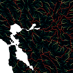
This specific dataset, at 15 arc-second resolution, measures the amount of upstream area (in cells) draining into each cell, indicating the upstream catchment area.
-
Data quality is lower above 60 degrees northern latitude due to the absence of underlying SRTM elevation data and the use of a coarser DEM.
-
The HydroSHEDS data is freely available for both non-commercial and commercial use under a specified license agreement.
- Dataset Availability
- 2000-02-11T00:00:00Z–2000-02-22T00:00:00Z
- Dataset Producer
- WWF
- Tags
Description
HydroSHEDS is a mapping product that provides hydrographic information for regional and global-scale applications in a consistent format. It offers a suite of geo-referenced datasets (vector and raster) at various scales, including river networks, watershed boundaries, drainage directions, and flow accumulations. HydroSHEDS is based on elevation data obtained in 2000 by NASA's Shuttle Radar Topography Mission (SRTM).
This flow accumulation dataset defines the amount of upstream area (in number of cells) draining into each cell. The drainage direction layer is used to define which cells flow into the target cell. The number of accumulated cells is essentially a measure of the upstream catchment area. However, since the cell size of the HydroSHEDS data set depends on latitude, the cell accumulation value cannot directly be translated into drainage areas in square kilometers. Values range from 1 at topographic highs (river sources) to very large numbers (on the order of millions of cells) at the mouths of large rivers.
This dataset is at 15 arc-second resolution. The datasets available at 15 arc-seconds are the Hydrologically Conditioned DEM, Drainage (Flow) Direction, and Flow Accumulation.
Note that the quality of the HydroSHEDS data is significantly lower for regions above 60 degrees northern latitude as there is no underlying SRTM elevation data available and thus a coarser-resolution DEM was (HYDRO1k provided by USGS).
HydroSHEDS was developed by the World Wildlife Fund (WWF) Conservation Science Program in partnership with the U.S. Geological Survey, the International Centre for Tropical Agriculture, The Nature Conservancy, and the Center for Environmental Systems Research of the University of Kassel, Germany.
Bands
Bands
Pixel size: 463.83 meters (all bands)
| Name | Min | Max | Pixel Size | Description |
|---|---|---|---|---|
b1 |
1* | 2.78651e+07* | 463.83 meters | Flow accumulation |
Terms of Use
Terms of Use
HydroSHEDS data are free for non-commercial and commercial use. For more information, please refer to the License Agreement.
Citations
Lehner, B., Verdin, K., Jarvis, A. (2008): New global hydrography derived from spaceborne elevation data. Eos, Transactions, AGU, 89(10): 93-94.
Explore with Earth Engine
Code Editor (JavaScript)
var dataset = ee.Image('WWF/HydroSHEDS/15ACC');
var flowAccumulation = dataset.select('b1');
var flowAccumulationVis = {
  min: 0.0,
  max: 500.0,
  palette: [
    '000000', '023858', '006837', '1a9850', '66bd63', 'a6d96a', 'd9ef8b',
    'ffffbf', 'fee08b', 'fdae61', 'f46d43', 'd73027'
  ],
};
Map.setCenter(-121.652, 38.022, 8);
Map.addLayer(flowAccumulation, flowAccumulationVis, 'Flow Accumulation');