Page Summary
-
The 2020 North American Land Cover 30-meter dataset is part of the North American Land Change Monitoring System (NALCMS), a collaboration between Canada, Mexico, and the United States.
-
This dataset provides 30-meter land cover information for North America, based on data from 2020 for Canada and Mexico, 2019 for the conterminous United States, and 2021 for Alaska.
-
The dataset was created by combining national land cover maps generated by each country using their own methodologies and inputs, primarily 30-meter Landsat 8 data.
-
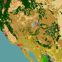
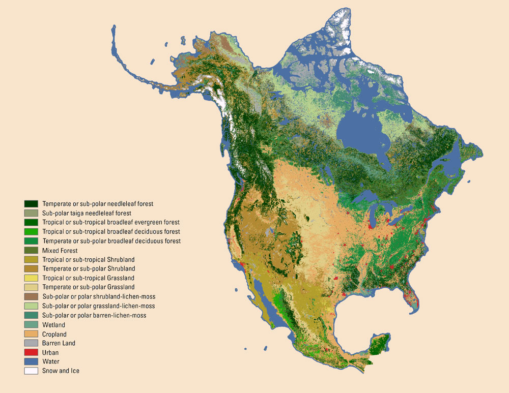
The dataset includes a 'landcover' band with 19 distinct land cover classifications ranging from various forest types and shrublands to wetlands, cropland, urban areas, and water.
-
This work is a work of the United States Government and is in the public domain, available for copying, modification, distribution, and performance, even for commercial purposes, without asking permission.
- Dataset Availability
- 2019-01-01T00:00:00Z–2021-12-31T00:00:00Z
- Dataset Producer
- The Commission for Environmental Cooperation (CEC)
- Tags
Description
The 2020 North American Land Cover 30-meter dataset was produced as part of the North American Land Change Monitoring System (NALCMS), a trilateral effort between Natural Resources Canada, the United States Geological Survey, and three Mexican organizations including the National Institute of Statistics and Geography (Instituto Nacional de Estadística y Geografía), National Commission for the Knowledge and Use of the Biodiversity (Comisión Nacional Para el Conocimiento y Uso de la Biodiversidad), and the National Forestry Commission of Mexico (Comisión Nacional Forestal). The collaboration is facilitated by the Commission for Environmental Cooperation, an international organization created by the Canada, Mexico, and United States governments under the North American Agreement on Environmental Cooperation to promote environmental collaboration between the three countries.
The general objective of NALCMS is to devise, through collective effort, a harmonized multi-scale land cover monitoring approach which ensures high accuracy and consistency in monitoring land cover changes at the North American scale and which meets each country's specific requirements.
This 30-meter dataset of North American Land Cover reflects land cover information for 2020 from Mexico and Canada, 2019 over the conterminous United States and 2021 over Alaska. Each country developed its own classification method to identify Land Cover classes and then provided an input layer to produce a continental Land Cover map across North America. Canada, Mexico, and the United States developed their own 30-meter land cover products; see specific sections on data generation below.
The main inputs for image classification were 30-meter Landsat 8 Collection 2 Level 1 data in the three countries (Canada, the United States and Mexico). Image selection processes and reduction to specific spectral bands varied among the countries due to study-site-specific requirements. While Canada selected most images from the year 2020 with a few from 2019 and 2021, the Conterminous United States employed mainly images from 2019, while Alaska land cover maps are mainly based on the use of images from 2021. The land cover map for Mexico was based on land cover change detection between 2015 and 2020 Mexico Landsat 8 mosaics.
In order to generate a seamless and consistent land cover map of North America, national maps were generated for Canada by the CCRS; for Mexico by CONABIO, INEGI, and CONAFOR; and for the United States by the USGS. Each country chose their own approaches, ancillary data, and land cover mapping methodologies to create national datasets. This North America dataset was produced by combining the national land cover datasets. The integration of the three national products merged four Land Cover map sections, Alaska, Canada, the conterminous United States and Mexico.
See also:
Natural Resources Canada has North American Land Cover information available online at https://open.canada.ca/data/en/dataset/ee1580ab-a23d-4f86-a09b-79763677eb47
The National Commission for the Knowledge and Use of Biodiversity has North American Land Cover information available online at https://www.biodiversidad.gob.mx/monitoreo/cobertura-suelo
The U.S. Geological Survey has North American Land Cover information available online at www.mrlc.gov
Bands
Bands
Pixel size: 30 meters (all bands)
| Name | Min | Max | Pixel Size | Description |
|---|---|---|---|---|
landcover |
1 | 19 | 30 meters | Land cover classification grid cell value. Values are categorized into the following. Product Legend. The classes in the 2020 product legend are given below. |
landcover Class Table
| Value | Color | Description |
|---|---|---|
| 1 | #033e00 | Temperate or sub-polar needleleaf forest. Forests generally taller than three meters and more than 20 percent of total vegetation cover. This type occurs across the northern United States, Canada, and mountainous zones of Mexico. The tree crown cover contains at least 75 percent of needleleaved species. |
| 2 | #939b71 | Sub-polar taiga needleleaf forest. Forest and woodlands with trees generally taller than three meters and more than 5 percent of total vegetation cover with shrubs and lichens commonly present in the understory. The tree crown cover contains at least 75 percent of needleleaved species. This type occurs across Alaska and northern Canada and may consist of treed muskeg or wetlands. Forest canopies are variable and often sparse, with generally greater tree cover in the southern latitude parts of the zone than the north. |
| 3 | #196d12 | Tropical or sub-tropical broadleaf evergreen forest. Forests generally taller than five meters and more than 20 percent of total vegetation cover. These occur in the southern United States and Mexico. These forests have greater than 75 percent of tree crown cover represented by evergreen species. |
| 4 | #1fab01 | Tropical or sub-tropical broadleaf deciduous forest. Forests generally taller than five meters and more than 20 percent of total vegetation cover. These occur in the southern United States and Mexico. These forests have greater than 75 percent of tree crown cover represented by deciduous species. |
| 5 | #5b725c | Temperate or sub-polar broadleaf deciduous forest. Forests generally taller than three meters and more than 20 percent of total vegetation cover. These occur in the northern United States, Canada and mountainous zones of Mexico. These forests have greater than 75 percent of tree crown cover represented by deciduous species. |
| 6 | #6b7d2c | Mixed forest. Forests generally taller than three meters and more than 20 percent of total vegetation cover. Neither needleleaf nor broadleaf tree species occupy more than 75 percent of total tree cover but are co-dominant. |
| 7 | #b29d29 | Tropical or sub-tropical shrubland. Areas dominated by woody perennial plants with persistent woody stems less than five meters tall and typically greater than 20 percent of total vegetation. This class occurs across the southern United States and Mexico. |
| 8 | #b48833 | Temperate or sub-polar shrubland. Areas dominated by woody perennial plants with persistent woody stems less than three meters tall and typically greater than 20 percent of total vegetation. This class occurs across the northern United States, Canada and highlands of Mexico. |
| 9 | #e9da5d | Tropical or sub-tropical grassland. Areas dominated by graminoid or herbaceous vegetation generally accounting for greater than 80 percent of total vegetation cover. These areas are not subject to intensive management such as tilling but can be utilized for grazing. This class occurs across the southern United States and Mexico. |
| 10 | #e0cd88 | Temperate or sub-polar grassland. Areas dominated by graminoid or herbaceous vegetation, generally accounting for greater than 80 percent of total vegetation cover. These areas are not subject to intensive management such as tilling but can be utilized for grazing. This class occurs across Canada, United States and highlands of Mexico. |
| 11 | #a07451 | Sub-polar or polar shrubland-lichen-moss. Areas dominated by dwarf shrubs with lichen and moss typically accounting for at least 20 percent of total vegetation cover. This class occurs across northern Canada and Alaska. |
| 12 | #bad292 | Sub-polar or polar grassland-lichen-moss. Areas dominated by grassland with lichen and moss typically accounting for at least 20 percent of total vegetation cover. This class occurs across northern Canada and Alaska. |
| 13 | #3f8970 | Sub-polar or polar barren-lichen-moss. Areas dominated by a mixture of bare areas with lichen and moss that typically account for at least 20 percent of total vegetation cover. This class occurs across northern Canada. |
| 14 | #6ca289 | Wetland. Areas dominated by perennial herbaceous and woody wetland vegetation which is influenced by the water table at or near surface over extensive periods of time. This includes marshes, swamps, bogs, mangroves, etc., either coastal or inland where water is present for a substantial period annually. |
| 15 | #e6ad6a | Cropland. Areas dominated by intensively managed crops. These areas typically require human activities for their maintenance. This includes areas used for the production of annual crops, such as corn, soybeans, wheat, maize, vegetables, tobacco, cotton, etc.; perennial grasses for grazing; and woody crops such as orchards and vineyards. Crop vegetation accounts for greater than 20 percent of total vegetation. This class does not represent natural grasslands used for light to moderate grazing. |
| 16 | #a9abae | Barren lands. Areas characterized by bare rock, gravel, sand, silt, clay, or other earthen material, with little or no "green" vegetation present regardless of its inherent ability to support life. Generally, vegetation accounts for less than 10 percent of total cover. |
| 17 | #db2126 | Urban and built-up. Areas that contain at least 30 percent or greater urban constructed materials for human activities (cities, towns, transportation etc.) |
| 18 | #4c73a1 | Water. Areas of open water, generally with less than 25 percent cover of non-water cover types. This class refers to areas that are consistently covered by water. |
| 19 | #fff7fe | Snow and ice. Areas characterized by a perennial cover of ice and/or snow, generally greater than 25 percent of total cover. |
Terms of Use
Terms of Use
This work was authored as part of the Contributor's official duties as an Employee of the United States Government and is therefore a work of the United States Government. In accordance with 17 U.S.C. 105, no copyright protection is available for such works under U.S. Law. This is an Open Access article that has been identified as being free of known restrictions under copyright law, including all related and neighboring rights https://creativecommons.org/publicdomain/mark/1.0/. You can copy, modify, distribute and perform the work, even for commercial purposes, all without asking permission.
Citations
North American Land Change Monitoring System download webpage. www.cec.org/north-american-land-change-monitoring-system
Explore with Earth Engine
Code Editor (JavaScript)
// Import the NALCMS image.
var image = ee.Image('USGS/NLCD_RELEASES/2020_REL/NALCMS');

Map.addLayer(
  image,
  {
    palette: [
      '033e00',  // 1  Temperate or sub-polar needleleaf forest
      '939b71',  // 2  Sub-polar taiga needleleaf forest
      '196d12',  // 3  Tropical or sub-tropical broadleaf evergreen forest
      '1fab01',  // 4  Tropical or sub-tropical broadleaf deciduous forest
      '5b725c',  // 5  Temperate or sub-polar broadleaf deciduous forest
      '6b7d2c',  // 6  Mixed forest
      'b29d29',  // 7  Tropical or sub-tropical shrubland
      'b48833',  // 8  Temperate or sub-polar shrubland
      'e9da5d',  // 9  Tropical or sub-tropical grassland
      'e0cd88',  // 10  Temperate or sub-polar grassland
      'a07451',  // 11  Sub-polar or polar shrubland-lichen-moss
      'bad292',  // 12  Sub-polar or polar grassland-lichen-moss
      '3f8970',  // 13  Sub-polar or polar barren-lichen-moss
      '6ca289',  // 14  Wetland
      'e6ad6a',  // 15  Cropland
      'a9abae',  // 16  Barren land
      'db2126',  // 17  Urban and built-up
      '4c73a1',  // 18  Water
      'fff7fe',  // 19  Snow and ice
    ],
   min: 1,
   max: 19,
  },
  'NALCMS Land Cover');

Map.setCenter(-114, 38, 6);