Page Summary
-
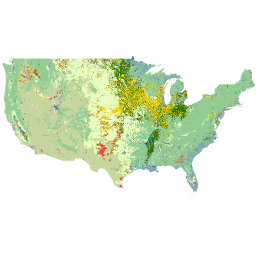
The Cropland Data Layer (CDL) provides annual, crop-specific land cover data for the continental United States.
-
The dataset, created by USDA NASS, utilizes satellite imagery and ground truth data.
-
The dataset is available from 1997 to 2024 and is updated annually.
-
The data includes bands for cropland classification, cultivated land identification (2013-2023), and classification confidence (2008-2023).
-
The CDL is public domain with no copyright restrictions, but acknowledgment of USDA NASS is appreciated.
- Dataset Availability
- 1997-01-01T00:00:00Z–2025-01-01T00:00:00Z
- Dataset Producer
- USDA National Agricultural Statistics Service
- Cadence
- 1 Year
- Tags
Description
The Cropland Data Layer (CDL) is a crop-specific land cover data layer created annually for the continental United States using moderate resolution satellite imagery and extensive agricultural ground truth. The CDL is created by the USDA, National Agricultural Statistics Service (NASS), Research and Development Division, Geospatial Information Branch, Spatial Analysis Research Section.
For detailed FAQ please visit CropScape and Cropland Data Layers - FAQs.
To explore details about the classification accuracies and utility of the data, see state-level omission and commission errors by crop type and year.
The asset date is aligned with the calendar year of harvest. For most crops the planted and harvest year are the same. Some exceptions: winter wheat is unique, as it is planted in the prior year. A hay crop like alfalfa could have been planted years prior.
For winter wheat the data also have a class called "Double Crop Winter Wheat/Soybeans". Some mid-latitude areas of the US have conditions such that a second crop (usually soybeans) can be planted immediately after the harvest of winter wheat and itself still be harvested within the same year. So for mapping winter wheat areas use both classes (use both values 24 and 26).
While the CDL date is aligned with year of harvest, the map itself is more representative of what was planted. In other words, a small percentage of fields on a given year will not be harvested.
Some non-agricultural categories are duplicate due to two very different epochs in methodology.
The non-ag codes 63-65 and 81-88 are holdovers from the older methodology and will only appear in CDLs from 2007 and earlier. The non-ag codes from 111-195 are from the current methodology which uses the USGS NLCD as non-ag training and will only appear in CDLs 2007 and newer.
2007 was a transition year so there may be both sets of categories in the 2007 national product but will not appear within the same state.
Bands
Bands
Pixel size: 30 meters (all bands)
| Name | Min | Max | Pixel Size | Description |
|---|---|---|---|---|
cropland |
1 | 254 | 30 meters | Main crop-specific land cover classification. |
cultivated |
1 | 2 | 30 meters | Classification layer for identifying cultivated and non-cultivated land cover. Available from 2013 to 2023. |
confidence |
0 | 100 | 30 meters | Per-pixel predicted confidence of the given classification, with 0 being the least confident and 100 the most confident. Available from 2008 to 2023 (Note: Confidence for Florida and Washington D.C. is unavailable for 2010). |
cropland Class Table
| Value | Color | Description |
|---|---|---|
| 0 | #000000 | Background |
| 1 | #ffd400 | Corn |
| 2 | #ff2626 | Cotton |
| 3 | #00a9e6 | Rice |
| 4 | #ff9e0f | Sorghum |
| 5 | #267300 | Soybeans |
| 6 | #ffff00 | Sunflower |
| 10 | #70a800 | Peanuts |
| 11 | #00af4d | Tobacco |
| 12 | #e0a60f | Sweet Corn |
| 13 | #e0a60f | Pop or Orn Corn |
| 14 | #80d4ff | Mint |
| 21 | #e2007f | Barley |
| 22 | #8a6453 | Durum Wheat |
| 23 | #d9b56c | Spring Wheat |
| 24 | #a87000 | Winter Wheat |
| 25 | #d69dbc | Other Small Grains |
| 26 | #737300 | Dbl Crop WinWht/Soybeans |
| 27 | #ae017e | Rye |
| 28 | #a15889 | Oats |
| 29 | #73004c | Millet |
| 30 | #d69dbc | Speltz |
| 31 | #d1ff00 | Canola |
| 32 | #8099ff | Flaxseed |
| 33 | #d6d600 | Safflower |
| 34 | #d1ff00 | Rape Seed |
| 35 | #00af4d | Mustard |
| 36 | #ffa8e3 | Alfalfa |
| 37 | #a5f58d | Other Hay/Non Alfalfa |
| 38 | #00af4d | Camelina |
| 39 | #d69dbc | Buckwheat |
| 41 | #a900e6 | Sugarbeets |
| 42 | #a80000 | Dry Beans |
| 43 | #732600 | Potatoes |
| 44 | #00af4d | Other Crops |
| 45 | #b380ff | Sugarcane |
| 46 | #732600 | Sweet Potatoes |
| 47 | #ff6666 | Misc Vegs & Fruits |
| 48 | #ff6666 | Watermelons |
| 49 | #ffcc66 | Onions |
| 50 | #ff6666 | Cucumbers |
| 51 | #00af4d | Chick Peas |
| 52 | #00deb0 | Lentils |
| 53 | #55ff00 | Peas |
| 54 | #f5a27a | Tomatoes |
| 55 | #ff6666 | Caneberries |
| 56 | #00af4d | Hops |
| 57 | #80d4ff | Herbs |
| 58 | #e8beff | Clover/Wildflowers |
| 59 | #b2ffde | Sod/Grass Seed |
| 60 | #00af4d | Switchgrass |
| 61 | #bfbf7a | Fallow/Idle Cropland |
| 63 | #95ce93 | Forest |
| 64 | #c7d79e | Shrubland |
| 65 | #ccbfa3 | Barren |
| 66 | #ff00ff | Cherries |
| 67 | #ff91ab | Peaches |
| 68 | #b90050 | Apples |
| 69 | #704489 | Grapes |
| 70 | #007878 | Christmas Trees |
| 71 | #b39c70 | Other Tree Crops |
| 72 | #ffff80 | Citrus |
| 74 | #b6705c | Pecans |
| 75 | #00a884 | Almonds |
| 76 | #ebd6b0 | Walnuts |
| 77 | #b39c70 | Pears |
| 81 | #f7f7f7 | Clouds/No Data |
| 82 | #9c9c9c | Developed |
| 83 | #4d70a3 | Water |
| 87 | #80b3b3 | Wetlands |
| 88 | #e9ffbe | Nonag/Undefined |
| 92 | #00ffff | Aquaculture |
| 111 | #4d70a3 | Open Water |
| 112 | #d4e3fc | Perennial Ice/Snow |
| 121 | #9c9c9c | Developed/Open Space |
| 122 | #9c9c9c | Developed/Low Intensity |
| 123 | #9c9c9c | Developed/Med Intensity |
| 124 | #9c9c9c | Developed/High Intensity |
| 131 | #ccbfa3 | Barren |
| 141 | #95ce93 | Deciduous Forest |
| 142 | #95ce93 | Evergreen Forest |
| 143 | #95ce93 | Mixed Forest |
| 152 | #c7d79e | Shrubland |
| 176 | #e9ffbe | Grass/Pasture |
| 190 | #80b3b3 | Woody Wetlands |
| 195 | #80b3b3 | Herbaceous Wetlands |
| 204 | #00ff8c | Pistachios |
| 205 | #d69dbc | Triticale |
| 206 | #ff6666 | Carrots |
| 207 | #ff6666 | Asparagus |
| 208 | #ff6666 | Garlic |
| 209 | #ff6666 | Cantaloupes |
| 210 | #ff91ab | Prunes |
| 211 | #344a34 | Olives |
| 212 | #e67525 | Oranges |
| 213 | #ff6666 | Honeydew Melons |
| 214 | #ff6666 | Broccoli |
| 215 | #66994d | Avocados |
| 216 | #ff6666 | Peppers |
| 217 | #b39c70 | Pomegranates |
| 218 | #ff91ab | Nectarines |
| 219 | #ff6666 | Greens |
| 220 | #ff91ab | Plums |
| 221 | #ff6666 | Strawberries |
| 222 | #ff6666 | Squash |
| 223 | #ff91ab | Apricots |
| 224 | #00af4d | Vetch |
| 225 | #ffd400 | Dbl Crop WinWht/Corn |
| 226 | #ffd400 | Dbl Crop Oats/Corn |
| 227 | #ff6666 | Lettuce |
| 228 | #ffd400 | Dbl Crop Triticale/Corn |
| 229 | #ff6666 | Pumpkins |
| 230 | #8a6453 | Dbl Crop Lettuce/Durum Wht |
| 231 | #ff6666 | Dbl Crop Lettuce/Cantaloupe |
| 232 | #ff2626 | Dbl Crop Lettuce/Cotton |
| 233 | #e2007f | Dbl Crop Lettuce/Barley |
| 234 | #ff9e0f | Dbl Crop Durum Wht/Sorghum |
| 235 | #ff9e0f | Dbl Crop Barley/Sorghum |
| 236 | #a87000 | Dbl Crop WinWht/Sorghum |
| 237 | #ffd400 | Dbl Crop Barley/Corn |
| 238 | #a87000 | Dbl Crop WinWht/Cotton |
| 239 | #267300 | Dbl Crop Soybeans/Cotton |
| 240 | #267300 | Dbl Crop Soybeans/Oats |
| 241 | #ffd400 | Dbl Crop Corn/Soybeans |
| 242 | #000099 | Blueberries |
| 243 | #ff6666 | Cabbage |
| 244 | #ff6666 | Cauliflower |
| 245 | #ff6666 | Celery |
| 246 | #ff6666 | Radishes |
| 247 | #ff6666 | Turnips |
| 248 | #ff6666 | Eggplants |
| 249 | #ff6666 | Gourds |
| 250 | #ff6666 | Cranberries |
| 254 | #267300 | Dbl Crop Barley/Soybeans |
cultivated Class Table
| Value | Color | Description |
|---|---|---|
| 1 | #d3d3d3 | Non-cultivated |
| 2 | #b1b58c | Cultivated |
Image Properties
Image Properties
| Name | Type | Description |
|---|---|---|
| cropland_class_names | STRING_LIST | Array of cropland landcover classification names. |
| cropland_class_palette | STRING_LIST | Array of hex code color strings used for the classification palette. |
| cropland_class_values | INT_LIST | Value of the land cover classification. |
| cultivated_class_names | STRING_LIST | Array of cropland landcover classification names. |
| cultivated_class_palette | STRING_LIST | Array of hex code color strings used for the classification palette. |
| cultivated_class_values | INT_LIST | Value of the land cover classification. |
Terms of Use
Terms of Use
The NASS Cropland Data Layer has no copyright restrictions. The CDL is considered public domain and free to redistribute. However, NASS would appreciate acknowledgment for the usage of our CDL product.
Citations
USDA National Agricultural Statistics Service Cropland Data Layer. {YEAR}. Published crop-specific data layer [Online]. Available at https://nassgeodata.gmu.edu/CropScape/ (accessed {DATE}; verified {DATE}). USDA-NASS, Washington, DC.
Explore with Earth Engine
Code Editor (JavaScript)
var dataset = ee.ImageCollection('USDA/NASS/CDL')
                  .filter(ee.Filter.date('2018-01-01', '2019-12-31'))
                  .first();
var cropLandcover = dataset.select('cropland');
Map.setCenter(-100.55, 40.71, 4);
Map.addLayer(cropLandcover, {}, 'Crop Landcover');
import ee
import geemap.core as geemap
Colab (Python)
dataset = (
    ee.ImageCollection('USDA/NASS/CDL')
    .filter(ee.Filter.date('2018-01-01', '2019-12-31'))
    .first()
)

crop_landcover = dataset.select('cropland')

m = geemap.Map()
m.set_center(-100.55, 40.71, 4)
m.add_layer(crop_landcover, {}, 'Crop Landcover')
m