Page Summary
-
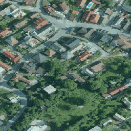
The Orthophotomosaic of the Slovak Republic is a set of color orthoimages available from 2017 to 2020.
-
This dataset provides R, G, and B bands with a pixel size of 0.25 meters.
-
Users can combine and publish the data for commercial and non-commercial purposes, provided they cite the author as "GKÚ Bratislava, NLC".
-
The dataset can be explored using the Google Earth Engine platform.
- Dataset Availability
- 2017-01-01T00:00:00Z–2020-01-01T00:00:00Z
- Dataset Producer
- Slovakia orthophotomosaic
- Tags
Description
Orthophotomosaic of the Slovak Republic is a set of color orthoimages without overlaps, gaps and visible brightness and color differences along the connecting lines.
For more information, please see the Slovakia orthophotos documentation
Bands
Bands
Pixel size: 0.25 meters (all bands)
| Name | Units | Min | Max | Pixel Size | Description |
|---|---|---|---|---|---|
R |
dn | 0 | 255 | 0.25 meters | Red |
G |
dn | 0 | 255 | 0.25 meters | Green |
B |
dn | 0 | 255 | 0.25 meters | Blue |
Terms of Use
Terms of Use
The User is entitled to combine the Source Data with other data, use it in the creation of his/her own work for commercial and non-commercial purposes, create a new work, publish the work on the Internet, publish the Source Data as a base map, publish the Source Data in connection with other data/thematic layers through web apps. The User is obliged to provide the name of the Author of the Source Data when creating his/her own work and when publishing it as follows: "GKÚ Bratislava, NLC".
For more details, see Terms of use
Citations
GKU Bratislava, NLC
Explore with Earth Engine
Code Editor (JavaScript)
var dataset = ee.ImageCollection('Slovakia/orthos/25cm');

Map.setCenter(19.163, 48.751, 15);
Map.addLayer(dataset, {}, 'Slovakia orthophotos RGB');