Page Summary
-
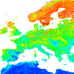
The dataset provides soil pH in H2O at six standard depths from 0 to 200 cm with a 250 m resolution.
-
The dataset spans from 1950 to 2018 and excludes Antarctica.
-
The data is available with a CC-BY-SA-4.0 license and can be accessed and visualized through Earth Engine or the OpenGeohub website.
-
The dataset includes bands for each of the six depths, with minimum and maximum pH values estimated.
-
Technical and general questions about the data can be addressed through provided GitLab and Disqus channels.
- Dataset Availability
- 1950-01-01T00:00:00Z–2018-01-01T00:00:00Z
- Dataset Producer
- EnvirometriX Ltd
- Tags
Description
Soil pH in H2O at 6 standard depths (0, 10, 30, 60, 100 and 200 cm) at 250 m resolution
Processing steps are described in detail here. Antarctica is not included.
To access and visualize maps outside of Earth Engine, use this page.
If you discover a bug, artifact or inconsistency in the LandGIS maps or if you have a question please use the following channels:
Bands
Bands
Pixel size: 250 meters (all bands)
| Name | Min | Max | Scale | Pixel Size | Description |
|---|---|---|---|---|---|
b0 |
42* | 110* | 10 | 250 meters | Soil pH in H2O at 0 cm depth |
b10 |
42* | 110* | 10 | 250 meters | Soil pH in H2O at 10 cm depth |
b30 |
42* | 110* | 10 | 250 meters | Soil pH in H2O at 30 cm depth |
b60 |
42* | 110* | 10 | 250 meters | Soil pH in H2O at 60 cm depth |
b100 |
42* | 110* | 10 | 250 meters | Soil pH in H2O at 100 cm depth |
b200 |
42* | 110* | 10 | 250 meters | Soil pH in H2O at 200 cm depth |
Terms of Use
Terms of Use
Citations
Tomislav Hengl. (2018). Soil pH in H2O at 6 standard depths (0, 10, 30, 60, 100 and 200 cm) at 250 m resolution (Version v02) [Data set]. Zenodo. 10.5281/zenodo.1475459
DOIs
Explore with Earth Engine
Code Editor (JavaScript)
var dataset = ee.Image('OpenLandMap/SOL/SOL_PH-H2O_USDA-4C1A2A_M/v02');

var visualization = {
  bands: ['b0'],
  min: 42,
  max: 110,
  palette: [
    'ff0000', 'ff1c00', 'ff3900', 'ff5500', 'ff7100', 'ff8e00',
    'ffaa00', 'ffc600', 'ffe200', 'ffff00', 'e3ff00', 'c7ff00',
    'aaff00', '8eff00', '72ff00', '55ff00', '39ff00', '1dff00',
    '01ff00', '00ff1c', '00ff38', '00ff54', '00ff71', '00ff8d',
    '00ffa9', '00ffc6', '00ffe2', '00fffe', '00e3ff', '00c7ff',
    '00abff', '008fff', '0072ff', '0056ff', '003aff', '001dff',
    '0001ff', '1b00ff', '3800ff', '5400ff',
  ]
};

Map.centerObject(dataset);

Map.addLayer(dataset, visualization, 'Soil pH x 10 in H2O');