Page Summary
-
The OpenET geeSEBAL implementation is based on the original SEBAL algorithms and uses Landsat Collection 2 LST data along with NLDAS and gridMET datasets for meteorological inputs.
-
The automated statistical algorithm selects hot and cold endmembers using a simplified version of the CIMEC algorithm, considering LST and NDVI values.
-
Improvements to the geeSEBAL algorithm include using additional filters for endmember selection, corrections to LST based on antecedent precipitation, and definition of wind speed thresholds.
-
The dataset provides monthly evapotranspiration (ET) values and the number of cloud-free values at a 30-meter pixel size.
-
The dataset is available from 1999-10-01 to 2024-12-01 and is provided by OpenET, Inc.under a CC-BY-4.0 license.
- Dataset Availability
- 1999-10-01T00:00:00Z–2024-12-01T00:00:00Z
- Dataset Producer
- OpenET, Inc.
- Cadence
- 1 Month
- Tags
Description
Implementation of geeSEBAL was recently completed within the OpenET framework and an overview of the current geeSEBAL version can be found in Laipelt et al. (2021), which is based on the original algorithms developed by Bastiaanssen et al. (1998). The OpenET geeSEBAL implementation uses land surface temperature (LST) data from Landsat Collection 2, in addition to NLDAS and gridMET datasets as instantaneous and daily meteorological inputs, respectively. The automated statistical algorithm to select the hot and cold endmembers is based on a simplified version of the Calibration using Inverse Modeling at Extreme Conditions (CIMEC) algorithm proposed by Allen et al. (2013), where quantiles of LST and the normalized difference vegetation index (NDVI) values are used to select endmember candidates in the Landsat domain area. The cold and wet endmember candidates are selected in well vegetated areas, while the hot and dry endmember candidates are selected in the least vegetated cropland areas. Based on the selected endmembers, geeSEBAL assumes that in the cold and wet endmember all available energy is converted to latent heat (with high rates of transpiration), while in the hot and dry endmember all available energy is converted to sensible heat. Finally, estimates of daily evapotranspiration are upscaled from instantaneous estimates based on the evaporative fraction, assuming it is constant during the daytime without significant changes in soil moisture and advection. Based on the results from the OpenET Accuracy Assessment and Intercomparison study, the OpenET geeSEBAL algorithm was modified as follows: (i) the simplified version of CIMEC was improved by using additional filters to select the endmembers, including the use of the USDA Cropland Data Layer (CDL) and filters for NDVI, LST and albedo; (ii) corrections to LST for endmembers based on antecedent precipitation; (iii) definition of NLDAS wind speed thresholds to reduce model instability during the atmospheric correction; and, (iv) improvements to estimate daily net radiation, using FAO-56 as reference (Allen et al., 1998). Overall, geeSEBAL performance is dependent on topographic, climate, and meteorological conditions, with higher sensitivity and uncertainty related to hot and cold endmember selections for the CIMEC automated calibration, and lower sensitivity and uncertainty related to meteorological inputs (Laipelt et al., 2021 and Kayser et al., 2022). To reduce uncertainties related to complex terrain, improvements were added to correct LST and global (incident) radiation on the surface (including the environmental lapse rate, elevation slope and aspect) to represent the effects of topographic features on the model’s endmember selection algorithm and ET estimates.
Bands
Pixel Size
30 meters
Bands
| Name | Units | Pixel Size | Description |
|---|---|---|---|
et |
mm | meters | geeSEBAL ET value |
count |
count | meters | Number of cloud free values |
Image Properties
Image Properties
| Name | Type | Description |
|---|---|---|
| build_date | STRING | Date assets were built |
| cloud_cover_max | DOUBLE | Maximum CLOUD_COVER_LAND percent value for Landsat images included in interpolation |
| collections | STRING | List of Landsat collections for Landsat images included in the interpolation |
| core_version | STRING | OpenET core library version |
| end_date | STRING | End date of month |
| et_reference_band | STRING | Band in et_reference_source that contains the daily reference ET data |
| et_reference_resample | STRING | Spatial interpolation mode to resample daily reference ET data |
| et_reference_source | STRING | Collection ID for the daily reference ET data |
| interp_days | DOUBLE | Maximum number of days before and after each image date to include in interpolation |
| interp_method | STRING | Method used to interpolate between Landsat model estimates |
| interp_source_count | DOUBLE | Number of available images in the interpolation source image collection for the target month |
| mgrs_tile | STRING | MGRS grid zone ID |
| model_name | STRING | OpenET model name |
| model_version | STRING | OpenET model version |
| scale_factor_count | DOUBLE | Scaling factor that should be applied to the count band |
| scale_factor_et | DOUBLE | Scaling factor that should be applied to the et band |
| start_date | STRING | Start date of month |
Terms of Use
Terms of Use
Citations
Laipelt, L., Kayser, R.H.B., Fleischmann, A.S., Ruhoff, A., Bastiaanssen, W., Erickson, T.A. and Melton, F., 2021. Long-term monitoring of evapotranspiration using the SEBAL algorithm and Google Earth Engine cloud computing. ISPRS Journal of Photogrammetry and Remote Sensing, 178, pp.81-96. doi:10.1016/j.isprsjprs.2021.05.018
Bastiaanssen, W.G., Menenti, M., Feddes, R.A. and Holtslag, A.A.M., 1998. A remote sensing surface energy balance algorithm for land (SEBAL). 1. Formulation. Journal of hydrology, 212, pp.198-212. doi:S0022-1694(98)00253-4
Kayser, R.H., Ruhoff, A., Laipelt, L., de Mello Kich, E., Roberti, D. R., de Arruda Souza, V., Rubert, G.C.D., Collischonn, W. and Neale, C.M.U., 2022. Assessing geeSEBAL automated calibration and meteorological reanalysis uncertainties to estimate evapotranspiration in subtropical humid climates. Agricultural and Forest Meteorology, 314, p.108775. doi:10.1016/j.agrformet.2021.108775
Allen, R.G., Burnett, B., Kramber, W., Huntington, J., Kjaersgaard, J., Kilic, A., Kelly, C. and Trezza, R., 2013. Automated calibration of the metric-landsat evapotranspiration process. JAWRA Journal of the American Water Resources Association, 49(3), pp.563-576. doi:10.1111/jawr.12056
DOIs
Explore with Earth Engine
Code Editor (JavaScript)
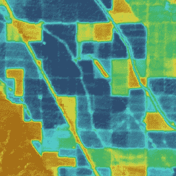
var dataset = ee.ImageCollection('OpenET/GEESEBAL/CONUS/GRIDMET/MONTHLY/v2_0')
  .filterDate('2020-01-01', '2021-01-01');

// Compute the annual evapotranspiration (ET) as the sum of the monthly ET
// images for the year.
var et = dataset.select('et').sum();

var visualization = {
  min: 0,
  max: 1400,
  palette: [
    '9e6212', 'ac7d1d', 'ba9829', 'c8b434', 'd6cf40', 'bed44b', '9fcb51',
    '80c256', '61b95c', '42b062', '45b677', '49bc8d', '4dc2a2', '51c8b8',
    '55cece', '4db4ba', '459aa7', '3d8094', '356681', '2d4c6e',
  ]
};

Map.setCenter(-100, 38, 5);

Map.addLayer(et, visualization, 'OpenET geeSEBAL Annual ET');