Page Summary
-
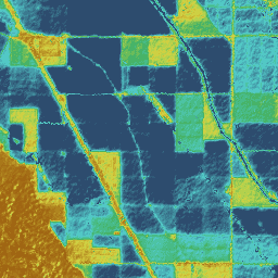
The dataset provides monthly evapotranspiration data based on the eeMETRIC model, which is a Google Earth Engine implementation of the METRIC algorithm.
-
The data is available from October 1999 to December 2024 and is provided by OpenET, Inc.
-
The eeMETRIC model uses Landsat imagery and incorporates advanced algorithms for estimating evapotranspiration, including methods for automated pixel selection and adjustments for complex terrain and different land surface types.
-
The dataset includes two bands: 'et' representing the eeMETRIC ET value in mm and 'count' indicating the number of cloud-free values, both with a pixel size of 30 meters.
- Dataset Availability
- 1999-10-01T00:00:00Z–2024-12-01T00:00:00Z
- Dataset Producer
- OpenET, Inc.
- Cadence
- 1 Month
- Tags
Description
Google Earth Engine implementation of the Mapping Evapotranspiration at high Resolution with Internalized Calibration model (eeMETRIC)
eeMETRIC applies the advanced METRIC algorithms and process of Allen et al. (2007; 2015) and Allen et al. (2013b), where a singular relationship between the near surface air temperature difference (dT) and delapsed land surface temperature (TsDEM) is used to estimate sensible heat flux (H) and is applied to each Landsat scene. Automated selection of the hot and cold pixels for an image generally follows a statistical isolation procedure described by Allen et al. (2013a) and ReVelle, Kilic and Allen (2019a,b). The calibration of H in eeMETRIC utilizes alfalfa reference ET calculated from the NLDAS gridded weather dataset using a fixed 15% reduction in computed reference ET to account for known biases in the gridded data set. The fixed reduction does not impact the calibration accuracy of eeMETRIC and mostly reduces impacts of boundary layer buoyancy correction.
The identification of candidates for pools of hot and cold pixels has evolved in the eeMETRIC implementation of METRIC. The new automated calibration process incorporates the combination of methodologies and approaches that stem from two development branches of EEFlux (Allen et al., 2015). The first branch focused on improving the automated pixel selection process using standard lapse rates for land surface temperature (LST) without any further spatial delapsing (ReVelle et al., 2019b). The second branch incorporated a secondary spatial delapsing of LST as well as changes to the pixel selection process (ReVelle et al., 2019a). The final, combined approach is described by Kilic et al. (2021).
eeMETRIC employs the aerodynamic-related functions in complex terrain (mountains) developed by Allen et al. (2013b) to improve estimates for aerodynamic roughness, wind speed and boundary layer stability as related to estimated terrain roughness, position on a slope and wind direction. These functions tend to increase estimates for H (and reduce ET) on windward slopes and may reduce H (and increase ET) on leeward slopes. Other METRIC functions employed in eeMETRIC that have been added since the descriptions provided in Allen et al. (2007 and 2011) include reduction in soil heat flux (G) in the presence of organic mulch on the ground surface, use of an excess aerodynamic resistance for shrublands, use of the Perrier function for trees identified as forest (Allen et al., 2018; Santos et al., 2012) and aerodynamic estimation of evaporation from open water rather than using energy balance (Jensen and Allen 2016; Allen et al., 2018). In 2022, the Perrier function was applied to tree (orchard) crops and a 3-source partitioning of bulk surface temperature into canopy temperature, shaded soil temperature and sunlit soil temperature was applied to both orchards and vineyards. These latter applications were made where orchards and vineyards are identified by CDL or, in California, by a state-sponsored land use system. These functions and other enhancements to the original METRIC model are described in the most current METRIC users manual (Allen et al., 2018). eeMETRIC uses the atmospherically corrected surface reflectance and LST from Landsat Collection 2 Level 2, with fallback to Collection 2 Level 1 when needed for near real-time estimates.
Bands
Bands
Pixel size: 30 meters (all bands)
| Name | Units | Pixel Size | Description |
|---|---|---|---|
et |
mm | 30 meters | eeMETRIC ET value |
count |
count | 30 meters | Number of cloud free values |
Image Properties
Image Properties
| Name | Type | Description |
|---|---|---|
| build_date | STRING | Date assets were built |
| cloud_cover_max | DOUBLE | Maximum CLOUD_COVER_LAND percent value for Landsat images included in interpolation |
| collections | STRING | List of Landsat collections for Landsat images included in the interpolation |
| core_version | STRING | OpenET core library version |
| end_date | STRING | End date of month |
| et_reference_band | STRING | Band in et_reference_source that contains the daily reference ET data |
| et_reference_resample | STRING | Spatial interpolation mode to resample daily reference ET data |
| et_reference_source | STRING | Collection ID for the daily reference ET data |
| interp_days | DOUBLE | Maximum number of days before and after each image date to include in interpolation |
| interp_method | STRING | Method used to interpolate between Landsat model estimates |
| interp_source_count | DOUBLE | Number of available images in the interpolation source image collection for the target month |
| mgrs_tile | STRING | MGRS grid zone ID |
| model_name | STRING | OpenET model name |
| model_version | STRING | OpenET model version |
| scale_factor_count | DOUBLE | Scaling factor that should be applied to the count band |
| scale_factor_et | DOUBLE | Scaling factor that should be applied to the et band |
| start_date | STRING | Start date of month |
Terms of Use
Terms of Use
Citations
Kilic, A., Allen, R.G., Blankenau, P., ReVelle, P., Ozturk, D. and Huntington, J., 2021. Global production and free access to Landsat-scale Evapotranspiration with EEFlux and eeMETRIC. In 6th Decennial National Irrigation Symposium, 6-8, December 2021, San Diego, California (p. 1). American Society of Agricultural and Biological Engineers. doi:10.13031/irrig.2020-038
Allen, R.G., Tasumi, M., Morse, A. and Trezza, R., 2005. A Landsat-based energy balance and evapotranspiration model in Western US water rights regulation and planning. Irrigation and Drainage systems, 19, pp.251-268. doi:10.1007/s10795-005-5187-z
Allen, R.G., Tasumi, M. and Trezza, R., 2007. Satellite-based energy balance for mapping evapotranspiration with internalized calibration (METRIC)—Model. Journal of irrigation and drainage engineering, 133(4), pp.380-394. doi:10.1029/2006JD007506
Allen, R., Irmak, A., Trezza, R., Hendrickx, J.M., Bastiaanssen, W. and Kjaersgaard, J., 2011. Satellite-based ET estimation in agriculture using SEBAL and METRIC. Hydrological Processes, 25(26), pp.4011-4027. doi:10.1002/hyp.8408
Allen, R.G., Burnett, B., Kramber, W., Huntington, J., Kjaersgaard, J., Kilic, A., Kelly, C. and Trezza, R., 2013a. Automated calibration of the metric-landsat evapotranspiration process. JAWRA Journal of the American Water Resources Association, 49(3), pp.563-576. doi:10.1111/jawr.12056
Allen, R.G., Trezza, R., Kilic, A., Tasumi, M. and Li, H., 2013b. Sensitivity of Landsat-scale energy balance to aerodynamic variability in mountains and complex terrain. JAWRA Journal of the American Water Resources Association, 49(3), pp.592-604. doi:10.1111/jawr.12055
Allen, R.G., Morton, C., Kamble, B., Kilic, A., Huntington, J., Thau, D., Gorelick, N., Erickson, T., Moore, R., Trezza, R. and Ratcliffe, I., 2015. EEFlux: A Landsat-based evapotranspiration mapping tool on the Google Earth Engine. In 2015 ASABE/IA Irrigation Symposium: Emerging Technologies for Sustainable Irrigation-A Tribute to the Career of Terry Howell, Sr. Conference Proceedings (pp. 1-11). American Society of Agricultural and Biological Engineers. doi:10.13031/irrig.20152143511
Jensen, M.E. and R.G. Allen (ed.). 2016. Evaporation, evapotranspiration, and irrigation water requirements. Manuals of Practice no. 70 (2nd edition). Task Committee on Revision of Manual 70, 2016, April. American Society of Civil Engineers. Reston, VA. 744 p. doi:10.1061/9780784414057
Kilic, A., Allen, R., Trezza, R., Ratcliffe, I., Kamble, B., Robison, C. and Ozturk, D., 2016. Sensitivity of evapotranspiration retrievals from the METRIC processing algorithm to improved radiometric resolution of Landsat 8 thermal data and to calibration bias in Landsat 7 and 8 surface temperature. Remote Sensing of Environment, 185, pp.198-209. doi:10.1016/j.rse.2016.07.011
ReVelle, P., A. Kilic and R.G. Allen. 2019a. Updated Calibration Description: Spatial Delapsing in eeMETRIC. Research Note. School of Natural Resources, University of Nebraska-Lincoln and University of Idaho. 9 p.
ReVelle, P., A. Kilic and R.G. Allen. 2019b. Updated Calibration Description: Automated Pixel Selection Method in eeMETRIC. Research Note. School of Natural Resources, University of Nebraska-Lincoln and University of Idaho. 20 p.
Santos, C., Lorite, I.J., Allen, R.G. and Tasumi, M., 2012. Aerodynamic parameterization of the satellite-based energy balance (METRIC) model for ET estimation in rainfed olive orchards of Andalusia, Spain. Water Resources Management, 26, pp.3267-3283. doi:10.1007/s11269-012-0071-8
DOIs
Explore with Earth Engine
Code Editor (JavaScript)
var dataset = ee.ImageCollection('OpenET/EEMETRIC/CONUS/GRIDMET/MONTHLY/v2_0')
  .filterDate('2020-01-01', '2021-01-01');

// Compute the annual evapotranspiration (ET) as the sum of the monthly ET
// images for the year.
var et = dataset.select('et').sum();

var visualization = {
  min: 0,
  max: 1400,
  palette: [
    '9e6212', 'ac7d1d', 'ba9829', 'c8b434', 'd6cf40', 'bed44b', '9fcb51',
    '80c256', '61b95c', '42b062', '45b677', '49bc8d', '4dc2a2', '51c8b8',
    '55cece', '4db4ba', '459aa7', '3d8094', '356681', '2d4c6e',
  ]
};

Map.setCenter(-100, 38, 5);

Map.addLayer(et, visualization, 'OpenET eeMETRIC Annual ET');