- Dataset Availability
- 2017-05-24T00:00:00Z–2024-04-26T20:16:17Z
- Dataset Provider
- NOAA
- Earth Engine Snippet
-
ee.ImageCollection("NOAA/GOES/16/FDCC") - Tags
Description
The Fire (HSC) product contains four images: one in the form of a fire mask and the other three with pixel values identifying fire temperature, fire area, and fire radiative power.
The ABI L2+ FHS metadata mask assigns a flag to every earth-navigated pixel that indicates its disposition with respect to the FHS algorithm. Operational users who have the lowest tolerance for false alarms should focus on the "processed" and "saturated" categories (mask codes 10, 11, 30, and 31), but within these categories there can still be false alarms.
NOAA provides the following scripts for suggested categories, color maps, and visualizations:
NOAA's Office of Satellite and Product Operations has a General Satellite Messages channel with status updates.
Bands
Resolution
2000 meters
Bands
| Name | Units | Min | Max | Scale | Offset | Description |
|---|---|---|---|---|---|---|
Area |
m^2 | 0* | 16723* | 60.98 | 4000 | Fire area |
Temp |
K | 0* | 32642* | 0.0549367 | 400 | Fire temperature |
Mask |
Fire mask categories. Pixel values in the fire mask image identify a fire category and diagnostic information associated with algorithm execution. The six fire categories include: Good quality or temporally filtered good quality fire pixel; Saturated fire pixel or temporally filtered saturated fire pixel; Cloud contaminated or temporally filtered cloud contaminated fire pixel; High probability or temporally filtered high probability fire pixel; Medium probability or temporally filtered high probability fire pixel; Low probability or temporally filtered high probability fire. Temporally filtered fire pixels are those resulting from fire pixels that are in close proximity in both space and time. |
|||||
Power |
MW | 0 | 200000 | Fire radiative power |
||
DQF |
0 | 5 | Data quality flags |
Mask Class Table
| Value | Color | Description |
|---|---|---|
| 10 | red | Processed fire |
| 11 | white | Saturated fire |
| 12 | slategray | Cloud contaminated fire |
| 13 | orange | High probability fire |
| 14 | violet | Medium probability fire |
| 15 | blue | Low probability fire |
| 30 | darkred | Processed fire, filtered |
| 31 | ghostwhite | Saturated fire, filtered |
| 32 | darkslategray | Cloud contaminated fire, filtered |
| 33 | darkorange | High probability fire, filtered |
| 34 | darkviolet | Medium probability fire, filtered |
| 35 | darkblue | Low probability fire, filtered |
DQF Class Table
| Value | Color | Description |
|---|---|---|
| 0 | #ffffff | Good quality fire |
| 1 | #ff00ff | Good quality fire-free land |
| 2 | #0000ff | Invalid due to opaque cloud |
| 3 | #00ffff | Invalid due to surface type or sunglint or LZA threshold exceeded or off earth or missing input data |
| 4 | #ffff00 | Invalid due to bad input data |
| 5 | #ff0000 | Invalid due to algorithm failure |
Terms of Use
Terms of Use
NOAA data, information, and products, regardless of the method of delivery, are not subject to copyright and carry no restrictions on their subsequent use by the public. Once obtained, they may be put to any lawful use.
Citations
Early characterization of the active fire detection products derived from the next generation NPOESS/VIIRS and GOES-R/ABI instruments. Schroeder, W., Csiszar, I., et al, (2010), Early characterization of the active fire detection products derived from the next generation NPOESS/VIIRS and GOES-R/ABI instruments, paper presented at 2010 IEEE International Geoscience and Remote Sensing Symposium (IGARSS), Honolulu, HI. doi:10.1109/IGARSS.2010.5650863
Schmit, T., Griffith, P., et al, (2016), A closer look at the ABI on the GOES-R series, Bull. Amer. Meteor. Soc., 98(4), 681-698. doi:10.1175/BAMS-D-15-00230.1
DOIs
Explore with Earth Engine
Code Editor (JavaScript)
// NOAA GOES-16 conterminous fire product for a single time slice.
var image = ee.Image('NOAA/GOES/16/FDCC/2019297103632900000');
var area = image.select('Area');
var temp = image.select('Temp');
var dqf = image.select('DQF');
var xmin = -145;
var ymin = 15;
var xmax = -55;
var ymax = 54;
var geometry = ee.Geometry.Rectangle({
coords: [xmin, ymin, xmax, ymax], geodesic: false});
Map.centerObject(geometry, 3);
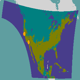
var DQFVis = {
min: 0,
max: 5,
palette: [
'blanchedalmond', // Good quality fire pixel
'olive', // Good quality fire free land
'teal', // Opaque cloud
// Bad surface type, sunglint, LZA threshold exceeded,
'darkslateblue', // off Earth, or missing input data
'lemonchiffon', // Bad input data
'burlywood' // Algorithm failure
]};
Map.addLayer(dqf, DQFVis, 'DQF');
// Fires are small enough that they are difficult to see at the scale of
// an entire GOES image. Buffer fires based on area to make them stand out.
var area = area.reduceToVectors({
geometry: geometry,
scale: 2000,
geometryType: 'centroid',
labelProperty: 'area',
maxPixels: 1e10,
}).map(function(feature){
return feature.buffer(ee.Number(feature.get('area')).add(1).pow(1.4));
});
Map.addLayer(area, {color: 'orange'}, 'area');
// Buffer fires based on temperature to make them stand out.
var temp = temp.reduceToVectors({
geometry: geometry,
scale: 2000,
geometryType: 'centroid',
labelProperty: 'temp',
maxPixels: 1e10,
}).map(function(feature){
return feature.buffer(ee.Number(feature.get('temp')).add(2).pow(1.27));
});
Map.setCenter(-75, 43.0, 3);
Map.addLayer(temp, {color: 'red'}, 'temp');