Page Summary
-
NASADEM is a reprocessing of SRTM data with improved accuracy using auxiliary datasets.
-
Processing improvements include void reduction through phase unwrapping and using ICESat GLAS data.
-
The dataset is available from February 11 to February 22, 2000.
-
It includes bands for elevation, source data index (
num), and updated water body data (swb) with a pixel size of 30 meters. -
NASA-produced data, like NASADEM, can be used for any purpose without prior permission.
- Dataset Availability
- 2000-02-11T00:00:00Z–2000-02-22T00:00:00Z
- Dataset Producer
- NASA / USGS / JPL-Caltech
- Tags
Description
NASADEM is a reprocessing of SRTM data, with improved accuracy by incorporating auxiliary data from ASTER GDEM, ICESat GLAS, and PRISM datasets.
The most significant processing improvements involve void reduction through improved phase unwrapping and using ICESat GLAS data for control.
Documentation:
Bands
Bands
Pixel size: 30 meters (all bands)
| Name | Units | Min | Max | Pixel Size | Description |
|---|---|---|---|---|---|
elevation |
m | -512* | 8768* | 30 meters | Integer heights in the merged void-free DEM files are relative to the EGM96 geoid (whereas the floating-point heights in the SRTM-only DEM files are relative to the WGS84 ellipsoid). |
num |
0 | 255 | 30 meters | Index indicating the data source and the number of source scenes.
|
|
swb |
0 | 255 | 30 meters | Updated SRTM water body data
|
swb Class Table
| Value | Color | Description |
|---|---|---|
| 0 | brown | Land |
| 255 | cadetblue | Water |
Terms of Use
Terms of Use
Unless otherwise noted, all NASA-produced data may be used for any purpose without prior permission. For more information and exceptions visit the NASA Data & Information Policy page.
Citations
NASA JPL (2020). NASADEM Merged DEM Global 1 arc second V001 [Data set]. NASA EOSDIS Land Processes DAAC. Accessed 2020-12-30 from doi:10.5067/MEaSUREs/NASADEM/NASADEM_HGT.001
Explore with Earth Engine
Code Editor (JavaScript)
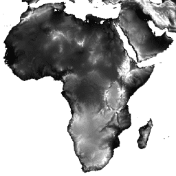
// Import the dataset and select the elevation band.
var dataset = ee.Image('NASA/NASADEM_HGT/001');
var elevation = dataset.select('elevation');

// Add a white background image to the map.
var background = ee.Image(1);
Map.addLayer(background, {min: 0, max: 1});

// Set elevation visualization properties.
var elevationVis = {
  min: 0,
  max: 2000,
};

// Set elevation <= 0 as transparent and add to the map.
Map.addLayer(elevation.updateMask(elevation.gt(0)), elevationVis, 'Elevation');
Map.setCenter(17.93, 7.71, 2);
import ee
import geemap.core as geemap
Colab (Python)
# Import the dataset and select the elevation band.
dataset = ee.Image('NASA/NASADEM_HGT/001')

elevation = dataset.select('elevation')

# Add a white background image to the map.
background = ee.Image(1)
m = geemap.Map()
m.set_center(17.93, 7.71, 2)
m.add_layer(background, {'min': 0, 'max': 1})

# Set elevation visualization properties.
elevation_vis = {'min': 0, 'max': 2000}

# Set elevation <= 0 as transparent and add to the map.
m.add_layer(elevation.updateMask(elevation.gt(0)), elevation_vis, 'Elevation')
m