Page Summary
-
The MCD19A1 Version 6.1 data product provides daily Land Surface Bidirectional Reflectance Factor data from MODIS Terra and Aqua at 500 meter and 1 kilometer resolution.
-
This dataset includes various bands measuring surface reflectance, BRF uncertainty, and quality assurance information, along with angles related to solar and view positions.
-
The data is available from December 21, 2000, to October 12, 2025, with a daily cadence and is provided by NASA LP DAAC at the USGS EROS Center.
-
MODIS data acquired through LP DAAC has no restrictions on subsequent use, sale, or redistribution.
- Dataset Availability
- 2000-12-21T00:00:00Z–2026-07-21T01:50:00Z
- Dataset Producer
- NASA LP DAAC at the USGS EROS Center
- Cadence
- 1 Day
- Tags
Description
The MCD19A1 Version 6.1 data product is a Moderate Resolution Imaging Spectroradiometer (MODIS) Terra and Aqua combined Land Surface Bidirectional Reflectance Factor (BRF) gridded Level 2 product produced daily at 500 meter and 1 kilometer resolution. For more information see the MAIAC user guide.
Bands
Bands
Pixel size: 1000 meters (all bands)
| Name | Min | Max | Scale | Pixel Size | Description | ||||||||||||||||||||||||||||||||||||||||||||||||||||||||||||||||||||||||||||||||||||||||||||||
|---|---|---|---|---|---|---|---|---|---|---|---|---|---|---|---|---|---|---|---|---|---|---|---|---|---|---|---|---|---|---|---|---|---|---|---|---|---|---|---|---|---|---|---|---|---|---|---|---|---|---|---|---|---|---|---|---|---|---|---|---|---|---|---|---|---|---|---|---|---|---|---|---|---|---|---|---|---|---|---|---|---|---|---|---|---|---|---|---|---|---|---|---|---|---|---|---|---|---|---|
Sur_refl1 |
-100 | 16000 | 0.0001 | 1000 meters | Surface reflectance at 500m for band 1. |
||||||||||||||||||||||||||||||||||||||||||||||||||||||||||||||||||||||||||||||||||||||||||||||
Sur_refl2 |
-100 | 16000 | 0.0001 | 1000 meters | Surface reflectance at 500m for band 2. |
||||||||||||||||||||||||||||||||||||||||||||||||||||||||||||||||||||||||||||||||||||||||||||||
Sur_refl3 |
-100 | 16000 | 0.0001 | 1000 meters | Surface reflectance at 500m for band 3. |
||||||||||||||||||||||||||||||||||||||||||||||||||||||||||||||||||||||||||||||||||||||||||||||
Sur_refl4 |
-100 | 16000 | 0.0001 | 1000 meters | Surface reflectance at 500m for band 4. |
||||||||||||||||||||||||||||||||||||||||||||||||||||||||||||||||||||||||||||||||||||||||||||||
Sur_refl5 |
-100 | 16000 | 0.0001 | 1000 meters | Surface reflectance at 500m for band 5. |
||||||||||||||||||||||||||||||||||||||||||||||||||||||||||||||||||||||||||||||||||||||||||||||
Sur_refl6 |
-100 | 16000 | 0.0001 | 1000 meters | Surface reflectance at 500m for band 6. |
||||||||||||||||||||||||||||||||||||||||||||||||||||||||||||||||||||||||||||||||||||||||||||||
Sur_refl7 |
-100 | 16000 | 0.0001 | 1000 meters | Surface reflectance at 500m for band 7. |
||||||||||||||||||||||||||||||||||||||||||||||||||||||||||||||||||||||||||||||||||||||||||||||
Sur_refl8 |
-100 | 16000 | 0.0001 | 1000 meters | Surface reflectance at 1km for band 8. |
||||||||||||||||||||||||||||||||||||||||||||||||||||||||||||||||||||||||||||||||||||||||||||||
Sur_refl9 |
-100 | 16000 | 0.0001 | 1000 meters | Surface reflectance at 1km for band 9. |
||||||||||||||||||||||||||||||||||||||||||||||||||||||||||||||||||||||||||||||||||||||||||||||
Sur_refl10 |
-100 | 16000 | 0.0001 | 1000 meters | Surface reflectance at 1km for band 10. |
||||||||||||||||||||||||||||||||||||||||||||||||||||||||||||||||||||||||||||||||||||||||||||||
Sur_refl11 |
-100 | 16000 | 0.0001 | 1000 meters | Surface reflectance at 1km for band 11. |
||||||||||||||||||||||||||||||||||||||||||||||||||||||||||||||||||||||||||||||||||||||||||||||
Sur_refl12 |
-100 | 16000 | 0.0001 | 1000 meters | Surface reflectance at 1km for band 12. |
||||||||||||||||||||||||||||||||||||||||||||||||||||||||||||||||||||||||||||||||||||||||||||||
Sigma_BRFn1 |
-100 | 16000 | 0.0001 | 1000 meters | BRFn uncertainty over time at 1km, for band 1 |
||||||||||||||||||||||||||||||||||||||||||||||||||||||||||||||||||||||||||||||||||||||||||||||
Sigma_BRFn2 |
-100 | 16000 | 0.0001 | 1000 meters | BRFn uncertainty over time at 1km, for band 2 |
||||||||||||||||||||||||||||||||||||||||||||||||||||||||||||||||||||||||||||||||||||||||||||||
Status_QA |
1000 meters | QA bits |
|||||||||||||||||||||||||||||||||||||||||||||||||||||||||||||||||||||||||||||||||||||||||||||||||
cosSZA |
0 | 10000 | 0.0001 | 1000 meters | Cosine of Solar zenith angle (5 km resolution) |
||||||||||||||||||||||||||||||||||||||||||||||||||||||||||||||||||||||||||||||||||||||||||||||
cosVZA |
0 | 10000 | 0.0001 | 1000 meters | Cosine view zenith angle (5 km resolution) |
||||||||||||||||||||||||||||||||||||||||||||||||||||||||||||||||||||||||||||||||||||||||||||||
RelAZ |
-18000 | 18000 | 0.01 | 1000 meters | Relative azimuth angle (5 km resolution) |
||||||||||||||||||||||||||||||||||||||||||||||||||||||||||||||||||||||||||||||||||||||||||||||
Scattering_Angle |
-18000 | 18000 | 0.01 | 1000 meters | Scattering angle (5 km resolution) |
||||||||||||||||||||||||||||||||||||||||||||||||||||||||||||||||||||||||||||||||||||||||||||||
SAZ |
-18000 | 18000 | 0.01 | 1000 meters | Solar Azimuth Angle (5 km resolution) |
||||||||||||||||||||||||||||||||||||||||||||||||||||||||||||||||||||||||||||||||||||||||||||||
VAZ |
-18000 | 18000 | 0.01 | 1000 meters | View Azimuth Angle (5 km resolution) |
||||||||||||||||||||||||||||||||||||||||||||||||||||||||||||||||||||||||||||||||||||||||||||||
Glint_Angle |
-18000 | 18000 | 0.01 | 1000 meters | Glint angle (5 km resolution) |
||||||||||||||||||||||||||||||||||||||||||||||||||||||||||||||||||||||||||||||||||||||||||||||
Fv |
-100 | 100 | 1000 meters | RTLS volumetric kernel (5 km resolution) |
|||||||||||||||||||||||||||||||||||||||||||||||||||||||||||||||||||||||||||||||||||||||||||||||
Fg |
-100 | 100 | 1000 meters | RTLS geometric kernel (5 km resolution) |
|||||||||||||||||||||||||||||||||||||||||||||||||||||||||||||||||||||||||||||||||||||||||||||||
Terms of Use
Terms of Use
MODIS data and products acquired through the LP DAAC have no restrictions on subsequent use, sale, or redistribution.
Citations
Please visit LP DAAC 'Citing Our Data' page for information on citing LP DAAC datasets.
DOIs
Explore with Earth Engine
Code Editor (JavaScript)
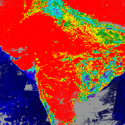
var collection = ee.ImageCollection('MODIS/061/MCD19A1_GRANULES')
                     .select('Sur_refl1')
                     .filterDate('2000-01-01', '2000-03-07');

var band_viz = {
  min: 0,
  max: 1100,
  palette: ['black', 'blue', 'purple', 'cyan', 'green', 'yellow', 'red']
};

Map.addLayer(collection.mean(), band_viz, 'Surface Bidirectional Reflectance Factor');
Map.setCenter(76, 13, 6);