Page Summary
-
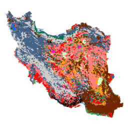
The Iran Land Cover Map v1 dataset provides a 13-class land cover map of Iran for the year 2017, generated using Sentinel imagery processed within Google Earth Engine.
-
This dataset, developed by K.N. Toosi University of Technology LiDAR Lab, utilized over 2,500 Sentinel-1 and 11,000 Sentinel-2 images.
-
The classification was performed using an object-based Random Forest method trained with a large number of reference samples.
-
The dataset includes a single band, 'classification', with a 10-meter pixel size, and a class table defining the 13 land cover types.
-
The dataset is available from 2017-01-01 to 2018-01-01 and is licensed under the Creative Commons Attribution 4.0 International License (CC BY 4.0).
- Dataset Availability
- 2017-01-01T00:00:00Z–2018-01-01T00:00:00Z
- Dataset Producer
- K. N. Toosi University of Technology LiDAR Lab
- Tags
Description
The Iran-wide land cover map was generated by processing Sentinel imagery within the Google Earth Engine Cloud platform. For this purpose, over 2,500 Sentinel-1 and over 11,000 Sentinel-2 images were processed to produce a single mosaic dataset for the year 2017. Then, an object-based Random Forest classification method was trained by a large number of reference samples for 13 classes to generate the Iran-wide land cover map.
Bands
Bands
Pixel size: 10 meters (all bands)
| Name | Pixel Size | Description |
|---|---|---|
classification |
10 meters | Classification |
classification Class Table
| Value | Color | Description |
|---|---|---|
| 1 | #000000 | Urban |
| 2 | #006eff | Water |
| 3 | #41a661 | Wetland |
| 4 | #ff7f7f | Kalut (yardang) |
| 5 | #bee8ff | Marshland |
| 6 | #ff00c5 | Salty Land |
| 7 | #ff0000 | Clay |
| 8 | #00734c | Forest |
| 9 | #732600 | Outcrop |
| 10 | #ffaa00 | Uncovered Plain |
| 11 | #d3ffbe | Sand |
| 12 | #446589 | Farm Land |
| 13 | #cccccc | Range Land |
Terms of Use
Terms of Use
This work "Iran Land Cover Map v1 13-class (2017)" by Arsalan Ghorbanian, Mohammad Kakooei, Meisam Amani, Sahel Mahdavi, Ali Mohammadzadeh, Mahdi Hasanlou is licensed under the Creative Commons Attribution 4.0 International License (CC BY 4.0)
Citations
Ghorbanian, A., Kakooei, M., Amani, M., Mahdavi, S., Mohammadzadeh, A., & Hasanlou, M. (2020). Improved land cover map of Iran using Sentinel imagery within Google Earth Engine and a novel automatic workflow for land cover classification using migrated training samples. ISPRS Journal of Photogrammetry and Remote Sensing, 167, 276-288. doi:10.1016/j.isprsjprs.2020.07.013
Explore with Earth Engine
Code Editor (JavaScript)
var dataset = ee.Image('KNTU/LiDARLab/IranLandCover/V1');

var visualization = {
  bands: ['classification']
};

Map.setCenter(54.0, 33.0, 5);

Map.addLayer(dataset, visualization, 'Classification');