Page Summary
-
This dataset maps the location and temporal distribution of surface water globally from 1984 to 2021.
-
It was generated using Landsat satellite imagery and provides statistics on the extent and changes in water surfaces.
-
The dataset includes seven bands representing different facets of surface water distribution and change, such as occurrence, seasonality, and transition.
-
Data are provided under the Copernicus Programme and are free to use with proper acknowledgement.
-
The dataset is available for analysis and visualization through Google Earth Engine.
- Dataset Availability
- 1984-03-16T00:00:00Z–2022-01-01T00:00:00Z
- Dataset Producer
- EC JRC / Google
- Tags
Description
This dataset contains maps of the location and temporal distribution of surface water from 1984 to 2021 and provides statistics on the extent and change of those water surfaces. For more information see the associated journal article: High-resolution mapping of global surface water and its long-term changes (Nature, 2016) and the online Data Users Guide.
These data were generated using 4,716,475 scenes from Landsat 5, 7, and 8 acquired between 16 March 1984 and 31 December 2021. Each pixel was individually classified into water / non-water using an expert system and the results were collated into a monthly history for the entire time period and two epochs (1984-1999, 2000-2021) for change detection.
This mapping layers product consists of 1 image containing 7 bands. It maps different facets of the spatial and temporal distribution of surface water over the last 38 years. Areas where water has never been detected are masked.
Note:: the mask value for the occurrence band is equal to the band value. That is, if the occurrence band is 0.5, the mask is also 0.5, so the dataset is double-counting the partial occurrence. This is probably not the intuitively expected behavior.
Bands
Bands
Pixel size: 30 meters (all bands)
| Name | Units | Min | Max | Pixel Size | Description | ||||||||||||||||||||||||||||||||||||||||||||||||||||||||||||||||||||||||||||||||||||||||||||||
|---|---|---|---|---|---|---|---|---|---|---|---|---|---|---|---|---|---|---|---|---|---|---|---|---|---|---|---|---|---|---|---|---|---|---|---|---|---|---|---|---|---|---|---|---|---|---|---|---|---|---|---|---|---|---|---|---|---|---|---|---|---|---|---|---|---|---|---|---|---|---|---|---|---|---|---|---|---|---|---|---|---|---|---|---|---|---|---|---|---|---|---|---|---|---|---|---|---|---|---|
occurrence |
% | 0 | 100 | 30 meters | The frequency with which water was present. |
||||||||||||||||||||||||||||||||||||||||||||||||||||||||||||||||||||||||||||||||||||||||||||||
change_abs |
% | -100 | 100 | 30 meters | Absolute change in occurrence between two epochs: 1984-1999 vs 2000-2021. |
||||||||||||||||||||||||||||||||||||||||||||||||||||||||||||||||||||||||||||||||||||||||||||||
change_norm |
% | -100 | 100 | 30 meters | Normalized change in occurrence. (epoch1-epoch2)/(epoch1+epoch2) * 100 |
||||||||||||||||||||||||||||||||||||||||||||||||||||||||||||||||||||||||||||||||||||||||||||||
seasonality |
0 | 12 | 30 meters | Number of months water is present. |
|||||||||||||||||||||||||||||||||||||||||||||||||||||||||||||||||||||||||||||||||||||||||||||||
recurrence |
% | 0 | 100 | 30 meters | The frequency with which water returns from year to year. |
||||||||||||||||||||||||||||||||||||||||||||||||||||||||||||||||||||||||||||||||||||||||||||||
transition |
30 meters | Categorical classification of change between first and last year. |
|||||||||||||||||||||||||||||||||||||||||||||||||||||||||||||||||||||||||||||||||||||||||||||||||
max_extent |
30 meters | Binary image containing 1 anywhere water has ever been detected. |
|||||||||||||||||||||||||||||||||||||||||||||||||||||||||||||||||||||||||||||||||||||||||||||||||
transition Class Table
| Value | Color | Description |
|---|---|---|
| 0 | #ffffff | No change |
| 1 | #0000ff | Permanent |
| 2 | #22b14c | New permanent |
| 3 | #d1102d | Lost permanent |
| 4 | #99d9ea | Seasonal |
| 5 | #b5e61d | New seasonal |
| 6 | #e6a1aa | Lost seasonal |
| 7 | #ff7f27 | Seasonal to permanent |
| 8 | #ffc90e | Permanent to seasonal |
| 9 | #7f7f7f | Ephemeral permanent |
| 10 | #c3c3c3 | Ephemeral seasonal |
Terms of Use
Terms of Use
All data here is produced under the Copernicus Programme and is provided free of charge, without restriction of use. For the full license information see the Copernicus Regulation.
Publications, models, and data products that make use of these datasets must include proper acknowledgement, including citing datasets and the journal article as in the following citation.
If you are using the data as a layer in a published map, please include the following attribution text: 'Source: EC JRC/Google'
Citations
Jean-Francois Pekel, Andrew Cottam, Noel Gorelick, Alan S. Belward, High-resolution mapping of global surface water and its long-term changes. Nature 540, 418-422 (2016). (doi:10.1038/nature20584)
Explore with Earth Engine
Code Editor (JavaScript)
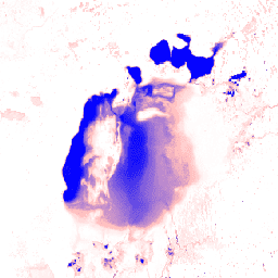
var dataset = ee.Image('JRC/GSW1_4/GlobalSurfaceWater');

var visualization = {
  bands: ['occurrence'],
  min: 0.0,
  max: 100.0,
  palette: ['ffffff', 'ffbbbb', '0000ff']
};

Map.setCenter(59.414, 45.182, 6);

Map.addLayer(dataset, visualization, 'Occurrence');
import ee
import geemap.core as geemap
Colab (Python)
dataset = ee.Image('JRC/GSW1_4/GlobalSurfaceWater')

visualization = {
    'bands': ['occurrence'],
    'min': 0.0,
    'max': 100.0,
    'palette': ['ffffff', 'ffbbbb', '0000ff'],
}

m = geemap.Map()
m.set_center(59.414, 45.182, 6)
m.add_layer(dataset, visualization, 'Occurrence')
m