Page Summary
-
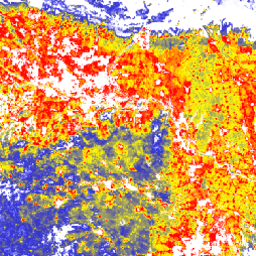
The "Tree Proximate People" (TPP) dataset provides global estimates for the number of people living in or near agricultural lands and croplands with at least 10% tree cover.
-
This dataset contributes to monitoring the number of forest-dependent people in extreme poverty, a key indicator for the Collaborative Partnership on Forests.
-
The TPP dataset offers four different estimates with 100-meter pixel size for the year 2019, distinguishing between 500m and 1km proximity to trees and agricultural land types.
-
The data is provided by the FAO Forestry Division and is available under the CC-BY-4.0 license for use.

- Dataset Availability
- 2019-01-01T00:00:00Z–2019-01-01T00:00:00Z
- Dataset Producer
- FAO Forestry Division (TPP 500m cropland) FAO Forestry Division (TPP 1km cropland) FAO Forestry Division (TPP 500m agricultural) FAO Forestry Division (TPP 1km agricultural)
- Cadence
- 1 Year
- Tags
Description
The "Tree Proximate People" (TPP) is one of the datasets contributing to the development of indicator #13, number of forest-dependent people in extreme poverty, of the Collaborative Partnership on Forests (CPF) Global Core Set of forest-related indicators (GCS). The TPP dataset provides 4 different estimates of tree proximate people (trees outside forests), all of them for the year 2019 with a pixel size of 100 meters at a global level. Find out more about the dataset.
Bands
Pixel Size
0.0009 meters
Bands
| Name | Units | Pixel Size | Description |
|---|---|---|---|
TPP_1km |
Number of people/ha | meters | Number of people living in or within 1 km from agricultural lands with at least 10% of tree cover |
TPP_1km_cropland |
Number of people/ha | meters | Number of people living in or within 1 km from croplands with at least 10% of tree cover |
TPP_500m |
Number of people/ha | meters | Number of people living in or within 500 m from agricultural lands with at least 10% of tree cover |
TPP_500m_cropland |
Number of people/ha | meters | Number of people living in or within 500 m from croplands with at least 10% of tree cover |
Terms of Use
Terms of Use
Citations
FAO 2022. The State of the World's Forests (SOFO) - Forest pathways for green recovery and building inclusive, resilient and sustainable economies. FAO, Rome. https://www.fao.org/documents/card/en/c/cb9360en
Newton, P., Castle, S.E., Kinzer, A.T., Miller, D.C., Oldekop, J.A., Linhares-Juvenal, T., Pina, L., Madrid, M., & de Lamo, J. 2022. The number of forest- and tree-proximate people: a new methodology and global estimates, One Earth, 2020 doi:10.1016/j.oneear.2020.08.016,
DOIs
Explore with Earth Engine
Code Editor (JavaScript)
var coll = ee.ImageCollection('FAO/SOFO/1/TPP');
var image = coll.first().select('TPP_1km');
Map.setCenter(17.5, 20, 3);
Map.addLayer(
    image, {min: 0, max: 12, palette: ['blue', 'yellow', 'red']},
    'Tree proximate people – 1km cutoff distance');