Page Summary
-
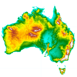
The Hydrologically Enforced Digital Elevation Model (DEM-H) is derived from SRTM data and designed for hydrological analysis.
-
This dataset captures flow paths based on SRTM elevations and mapped streamlines to support delineation of catchments and related hydrological attributes.
-
The DEM-H dataset has a pixel size of 30.92 meters and provides elevation data in meters.
-
Terms of use for this dataset are CC-BY-4.0.
- Dataset Availability
- 2010-02-01T00:00:00Z–2010-02-01T00:00:00Z
- Dataset Producer
- Geoscience Australia
- Tags
Description
The Hydrologically Enforced Digital Elevation Model (DEM-H) was derived from the SRTM data acquired by NASA in February 2000. The model has been hydrologically conditioned and drainage enforced. The DEM-H captures flow paths based on SRTM elevations and mapped stream lines, and supports delineation of catchments and related hydrological attributes. The dataset was derived from the 1 second smoothed Digital Elevation Model (DEM-S; ANZCW0703014016) by enforcing hydrological connectivity with the ANUDEM software, using selected AusHydro V1.6 (February 2010) 1:250,000 scale watercourse lines (ANZCW0503900101) and lines derived from DEM-S to define the watercourses. The drainage enforcement has produced a consistent representation of hydrological connectivity with some elevation artifacts resulting from the drainage enforcement. A full description of the methods is in preparation (Dowling et al., in prep).
This product provides a DEM suitable for use in hydrological analysis such as catchment definition and flow routing.
There are several areas with unexpected negative values: close to Canberra around (150.443044, -35.355281) with values of -55 and in Western Australia around (124.84, -16.44) with -43.
Bands
Bands
Pixel size: 30.92 meters (all bands)
| Name | Units | Min | Max | Pixel Size | Description |
|---|---|---|---|---|---|
elevation |
m | -31.37* | 2223.24* | 30.92 meters | Elevation |
Terms of Use
Terms of Use
Citations
Geoscience Australia, 2015. Digital Elevation Model (DEM) of Australia derived from LiDAR 5 Metre Grid. Geoscience Australia, Canberra.
Explore with Earth Engine
Code Editor (JavaScript)
var dataset = ee.Image('AU/GA/DEM_1SEC/v10/DEM-H');
var elevation = dataset.select('elevation');
var elevationVis = {
  min: -10.0,
  max: 1300.0,
  palette: [
    '3ae237', 'b5e22e', 'd6e21f', 'fff705', 'ffd611', 'ffb613', 'ff8b13',
    'ff6e08', 'ff500d', 'ff0000', 'de0101', 'c21301', '0602ff', '235cb1',
    '307ef3', '269db1', '30c8e2', '32d3ef', '3be285', '3ff38f', '86e26f'
  ],
};
Map.setCenter(133.95, -24.69, 5);
Map.addLayer(elevation, elevationVis, 'Elevation');