Page Summary
-
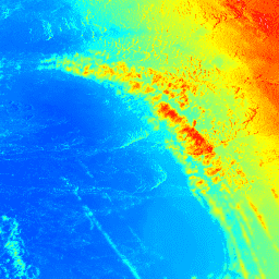
The Digital Elevation Model (DEM) 5 meter Grid of Australia is a national bare earth DEM derived from LiDAR surveys conducted between 2001 and 2015.
-
This dataset was created through collaboration between Geoscience Australia and various other organizations.
-
The dataset provides elevation data with a pixel size of 5 meters and is available under the Creative Commons Attribution 4.0 International License.
-
There are areas with null values near Perth in this dataset.

- Dataset Availability
- 2015-12-01T00:00:00Z–2015-12-01T00:00:00Z
- Dataset Producer
- Geoscience Australia
- Tags
Description
The Digital Elevation Model (DEM) 5 meter Grid of Australia derived from LiDAR model represents a National 5 meter (bare earth) DEM which has been derived from some 236 individual LiDAR surveys between 2001 and 2015 covering an area in excess of 245,000 square kilometers. These surveys cover Australia's populated coastal zone; floodplain surveys within the Murray Darling Basin, and individual surveys of major and minor population centers. All available 1 meter resolution LiDAR-derived DEMs have been compiled and resampled using a neighborhood-mean method to 5 meter resolution datasets for each survey area, and then merged into a single dataset for each State. Each state's dataset is provided as a separate image within the image collection.
The acquisition of the individual LiDAR surveys and derivation of the 5m product has been part of a long-term collaboration between Geoscience Australia, the Cooperative Research Centre for Spatial Information (CRCSI), the Departments of Climate Change and Environment, State and Territory jurisdictions, Local Government and the Murray Darling Basin Authority under the auspices of the National Elevation Data Framework and Coastal and Urban DEM Program. The source datasets have been captured to standards that are generally consistent with the Australian ICSM LiDAR Acquisition Specifications with require a fundamental vertical accuracy of at least 0.30m (95% confidence) and horizontal accuracy of at least 0.80m (95% confidence).
There are several areas close to Perth with null (NaN) values around (115.85, -31.99), (115.72, -33.75), and (115.10, -33.43).
Bands
Pixel Size
5 meters
Bands
| Name | Units | Pixel Size | Description |
|---|---|---|---|
elevation |
m | meters | Elevation |
Terms of Use
Terms of Use
This dataset is made available by Geoscience Australia under the Creative Commons Attribution 4.0 International License. The data must be referenced with the provided citation and DOI.
Citations
Geoscience Australia, 2015. Digital Elevation Model (DEM) of Australia derived from LiDAR 5 Metre Grid. Geoscience Australia, Canberra.
DOIs
Explore with Earth Engine
Code Editor (JavaScript)
var dataset = ee.ImageCollection('AU/GA/AUSTRALIA_5M_DEM');
var elevation = dataset.select('elevation');
var elevationVis = {
  min: 0.0,
  max: 150.0,
  palette: ['0000ff', '00ffff', 'ffff00', 'ff0000', 'ffffff'],
};
Map.setCenter(140.1883, -35.9113, 8);
Map.addLayer(elevation, elevationVis, 'Elevation');