Page Summary
-
The dataset contains annual crop type digital maps for Canada generated by Agriculture and Agri-Food Canada (AAFC) starting in 2009.
-
A Decision Tree (DT) methodology is applied using optical and radar satellite images to create the crop inventory.
-
The inventory aims for an overall accuracy of at least 85% with a spatial resolution of 30m (56m in 2009 and 2010).
-
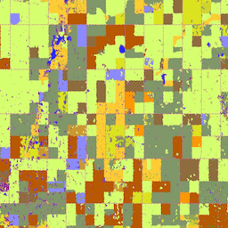
The dataset includes a single band representing main crop-specific land cover classification with a detailed class table.
-
This dataset is available for use under the OGL-Canada-2.0 license and can be explored using Google Earth Engine.
- Dataset Availability
- 2009-01-01T00:00:00Z–2024-01-01T00:00:00Z
- Dataset Producer
- Agriculture and Agri-Food Canada
- Cadence
- 1 Year
- Tags
Description
Starting in 2009, the Earth Observation Team of the Science and Technology Branch (STB) at Agriculture and Agri-Food Canada (AAFC) began the process of generating annual crop type digital maps. Focusing on the Prairie Provinces in 2009 and 2010, a Decision Tree (DT) based methodology was applied using optical (Landsat-5, AWiFS, DMC) and radar (Radarsat-2) based satellite images. Beginning with the 2011 growing season, this activity has been extended to other provinces in support of a national crop inventory. To date this approach can consistently deliver a crop inventory that meets the overall target accuracy of at least 85% at a final spatial resolution of 30m (56m in 2009 and 2010).
Bands
Bands
Pixel size: 30 meters (all bands)
| Name | Min | Max | Pixel Size | Description |
|---|---|---|---|---|
landcover |
10 | 230 | 30 meters | Main crop-specific land cover classification. |
landcover Class Table
| Value | Color | Description |
|---|---|---|
| 10 | #000000 | Cloud |
| 20 | #3333ff | Water |
| 30 | #996666 | Exposed Land and Barren |
| 34 | #cc6699 | Urban and Developed |
| 35 | #e1e1e1 | Greenhouses |
| 50 | #ffff00 | Shrubland |
| 60 | #666666 | Forest Fire and Burnt Area |
| 80 | #993399 | Wetland |
| 85 | #501b50 | Peatland |
| 110 | #cccc00 | Grassland |
| 120 | #cc6600 | Agriculture (undifferentiated) |
| 121 | #ff9933 | Cropland |
| 122 | #ffcc33 | Pasture and Forages |
| 130 | #7899f6 | Too Wet to be Seeded |
| 131 | #ff9900 | Fallow |
| 132 | #660000 | Cereals |
| 133 | #dae31d | Barley |
| 134 | #99cc00 | Other Grains |
| 135 | #d2db25 | Millet |
| 136 | #d1d52b | Oats |
| 137 | #cacd32 | Rye |
| 138 | #c3c63a | Spelt |
| 139 | #b9bc44 | Triticale |
| 140 | #a7b34d | Wheat |
| 141 | #b9c64e | Switchgrass |
| 142 | #999900 | Sorghum |
| 143 | #e9e2b1 | Quinoa |
| 145 | #809769 | Winter Wheat |
| 146 | #92a55b | Spring Wheat |
| 147 | #ffff99 | Corn for Grain |
| 148 | #98887c | Tobacco |
| 149 | #799b93 | Ginseng |
| 150 | #5ea263 | Oilseeds |
| 151 | #52ae77 | Borage |
| 152 | #41bf7a | Camelina |
| 153 | #d6ff70 | Canola and Rapeseed |
| 154 | #8c8cff | Flaxseed |
| 155 | #d6cc00 | Mustard |
| 156 | #ff7f00 | Safflower |
| 157 | #315491 | Sunflower |
| 158 | #cc9933 | Soybeans |
| 159 | #5ea296 | Other Oilseeds |
| 160 | #896e43 | Pulses |
| 161 | #996633 | Other Pulses |
| 162 | #8f6c3d | Peas |
| 163 | #b6a472 | Chickpeas |
| 167 | #82654a | Beans |
| 168 | #a39069 | Fababeans |
| 174 | #b85900 | Lentils |
| 175 | #b74b15 | Vegetables |
| 176 | #ff8a8a | Tomatoes |
| 177 | #ffcccc | Potatoes |
| 178 | #6f55ca | Sugarbeets |
| 179 | #ffccff | Other Vegetables |
| 180 | #dc5424 | Fruits |
| 181 | #d05a30 | Berries |
| 182 | #d20000 | Blueberry |
| 183 | #cc0000 | Cranberry |
| 185 | #dc3200 | Other Berries |
| 188 | #ff6666 | Orchards |
| 189 | #c5453b | Other Fruits |
| 190 | #7442bd | Vineyards |
| 191 | #ffcc99 | Hops |
| 192 | #b5fb05 | Sod |
| 193 | #ccff05 | Herbs |
| 194 | #07f98c | Nursery |
| 195 | #00ffcc | Buckwheat |
| 196 | #cc33cc | Canaryseed |
| 197 | #8e7672 | Hemp |
| 198 | #b1954f | Vetch |
| 199 | #749a66 | Other Crops |
| 200 | #009900 | Forest (undifferentiated) |
| 210 | #006600 | Coniferous |
| 220 | #00cc00 | Broadleaf |
| 230 | #cc9900 | Mixedwood |
Image Properties
Image Properties
| Name | Type | Description |
|---|---|---|
| landcover_class_names | STRING_LIST | Array of cropland landcover classification names. |
| landcover_class_palette | STRING_LIST | Array of hex code color strings used for the classification palette. |
| landcover_class_values | INT_LIST | Value of the land cover classification. |
Terms of Use
Terms of Use
Citations
Agriculture and Agri-Food Canada Annual Crop Inventory. {YEAR}
Explore with Earth Engine
Code Editor (JavaScript)
var dataset = ee.ImageCollection('AAFC/ACI');
var crop2016 = dataset
    .filter(ee.Filter.date('2016-01-01', '2016-12-31'))
    .first();
Map.setCenter(-103.8881, 53.0372, 10);
Map.addLayer(crop2016, {}, '2016 Canada AAFC Annual Crop Inventory');
import ee
import geemap.core as geemap
Colab (Python)
dataset = ee.ImageCollection('AAFC/ACI')
crop_2016 = dataset.filter(ee.Filter.date('2016-01-01', '2016-12-31')).first()

m = geemap.Map()
m.set_center(-103.8881, 53.0372, 10)
m.add_layer(crop_2016, {}, '2016 Canada AAFC Annual Crop Inventory')
m