データの取得
収集された位置情報を取得する方法は多数あります。ここでは、2 つの Pod の Google Cloud の Snap to Roads 機能で使用するデータ取得の手法 Roads API。
GPX
GPX は、ルート、トラック、ウェイポイントを共有するためのオープンな XML ベースの形式です キャプチャできますこの例では、XmlPull パーサーを使用します。 Java サーバー環境とモバイル環境の両方で利用できる軽量の XML パーサー。
/**
 * Parses the waypoint (wpt tags) data into native objects from a GPX stream.
 */
private List<LatLng> loadGpxData(XmlPullParser parser, InputStream gpxIn)
        throws XmlPullParserException, IOException {
    // We use a List<> as we need subList for paging later
    List<LatLng> latLngs = new ArrayList<>();
    parser.setInput(gpxIn, null);
    parser.nextTag();

    while (parser.next() != XmlPullParser.END_DOCUMENT) {
        if (parser.getEventType() != XmlPullParser.START_TAG) {
            continue;
        }

        if (parser.getName().equals("wpt")) {
            // Save the discovered latitude/longitude attributes in each <wpt>.
            latLngs.add(new LatLng(
                    Double.valueOf(parser.getAttributeValue(null, "lat")),
                    Double.valueOf(parser.getAttributeValue(null, "lon"))));
        }
        // Otherwise, skip irrelevant data
    }

    return latLngs;
}
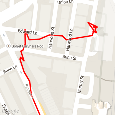
地図に読み込まれた GPX の未加工データは次のとおりです。
Android 位置情報サービス
Android デバイスから GPS データを取得する最善の方法は、 構築できます位置情報の取得に関する Android トレーニング クラスをご覧ください。 最新情報、および Google Play Location サンプルの GitHub。
長いパスの処理
道路へのスナップ機能はフルパスに基づいて位置を推測するため、 個々のデータポイントではなく (リクエスト 1 件あたりの上限である 100 ポイントを超えるパス)。
個々のリクエストを 1 つの長いパスとして扱うには、 一部重複し、前のリクエストの最後のポイントが含まれる 後続のリクエストの最初のポイントとして使用します。追加するポイントの数 データの精度に依存します。ポイント数を増やしてください 精度の低いリクエストに対して 再試行されます
この例では、Google マップ サービス用の Java クライアントを使用して、ページング リクエストを送信し、 その後、補間されたポイントを含むデータを、返されたリストに再結合します。
/**
 * Snaps the points to their most likely position on roads using the Roads API.
 */
private List<SnappedPoint> snapToRoads(GeoApiContext context) throws Exception {
    List<SnappedPoint> snappedPoints = new ArrayList<>();

    int offset = 0;
    while (offset < mCapturedLocations.size()) {
        // Calculate which points to include in this request. We can't exceed the API's
        // maximum and we want to ensure some overlap so the API can infer a good location for
        // the first few points in each request.
        if (offset > 0) {
            offset -= PAGINATION_OVERLAP;   // Rewind to include some previous points.
        }
        int lowerBound = offset;
        int upperBound = Math.min(offset + PAGE_SIZE_LIMIT, mCapturedLocations.size());

        // Get the data we need for this page.
        LatLng[] page = mCapturedLocations
                .subList(lowerBound, upperBound)
                .toArray(new LatLng[upperBound - lowerBound]);

        // Perform the request. Because we have interpolate=true, we will get extra data points
        // between our originally requested path. To ensure we can concatenate these points, we
        // only start adding once we've hit the first new point (that is, skip the overlap).
        SnappedPoint[] points = RoadsApi.snapToRoads(context, true, page).await();
        boolean passedOverlap = false;
        for (SnappedPoint point : points) {
            if (offset == 0 || point.originalIndex >= PAGINATION_OVERLAP - 1) {
                passedOverlap = true;
            }
            if (passedOverlap) {
                snappedPoints.add(point);
            }
        }

        offset = upperBound;
    }

    return snappedPoints;
}
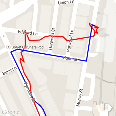
以下は、道路へのスナップ リクエストを実行した後の上記のデータです。赤 線が元データ、青い線がスナップされたデータです。
割り当ての効率的な使用
道路へのスナップ リクエストに対するレスポンスには、プレイス ID のリストが含まれます。
マッピングされ、必要に応じて追加のポイントが
interpolate=true を設定します。
制限速度リクエストで許可された割り当てを効率的に使用するには、 リクエストでは一意のプレイス ID のみをクエリしてください。この例では、 Google マップサービスの Java クライアント: 場所のリストから制限速度をクエリできます あります。
/**
 * Retrieves speed limits for the previously-snapped points. This method is efficient in terms
 * of quota usage as it will only query for unique places.
 *
 * Note: Speed limit data is only available for requests using an API key enabled for a
 * Google Maps APIs Premium Plan license.
 */
private Map<String, SpeedLimit> getSpeedLimits(GeoApiContext context, List<SnappedPoint> points)
        throws Exception {
    Map<String, SpeedLimit> placeSpeeds = new HashMap<>();

    // Pro tip: Save on quota by filtering to unique place IDs.
    for (SnappedPoint point : points) {
        placeSpeeds.put(point.placeId, null);
    }

    String[] uniquePlaceIds =
            placeSpeeds.keySet().toArray(new String[placeSpeeds.keySet().size()]);

    // Loop through the places, one page (API request) at a time.
    for (int i = 0; i < uniquePlaceIds.length; i += PAGE_SIZE_LIMIT) {
        String[] page = Arrays.copyOfRange(uniquePlaceIds, i,
                Math.min(i + PAGE_SIZE_LIMIT, uniquePlaceIds.length));

        // Execute!
        SpeedLimit[] placeLimits = RoadsApi.speedLimits(context, page).await();
        for (SpeedLimit sl : placeLimits) {
            placeSpeeds.put(sl.placeId, sl);
        }
    }

    return placeSpeeds;
}
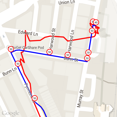
以下は、上記のデータで、一意のプレイス ID ごとに制限速度がマークされています。
他の API との連携
snap to Roads でプレイス ID が返されるメリットの一つは、 多くのイベントでプレイス ID を Google Maps Platform API。この例では、Google マップサービス用の Java クライアントを使用します。 上記のスナップ to Road リクエストで返された場所をジオコーディングします。
/**
 * Geocodes a snapped point using the place ID.
 */
private GeocodingResult geocodeSnappedPoint(GeoApiContext context, SnappedPoint point) throws Exception {
    GeocodingResult[] results = GeocodingApi.newRequest(context)
            .place(point.placeId)
            .await();

    if (results.length > 0) {
        return results[0];
    }
    return null;
}
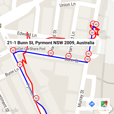
ここでは、制限速度マーカーに、 Geocoding API
サンプルコード
考慮事項
この記事をサポートするコードは、 使用しないでください。実際には、サーバー サイドのサーバーを Android アプリで API キーを使用するのは、鍵を不正使用から保護できないためです。 できます。鍵のセキュリティを確保するには、代わりに API 公開コードをサーバーサイド プロキシとして実行し、Android アプリからリクエストを送信させる リクエストが確実に承認されるようにします。
ダウンロード
GitHub からコードをダウンロードします。