
Tutorial ini menunjukkan cara menambahkan peta Google ke aplikasi Android, dan menggunakan polyline serta poligon untuk merepresentasikan rute dan area pada peta.
Ikuti tutorial ini untuk membangun aplikasi Android menggunakan Maps SDK for Android. Lingkungan pengembangan yang direkomendasikan adalah Android Studio.
Mendapatkan kode
Lakukan clone atau download repositori Google Maps Android API v2 Samples dari GitHub.
Lihat versi Java aktivitas:
    // Copyright 2020 Google LLC
//
// Licensed under the Apache License, Version 2.0 (the "License");
// you may not use this file except in compliance with the License.
// You may obtain a copy of the License at
//
//      http://www.apache.org/licenses/LICENSE-2.0
//
// Unless required by applicable law or agreed to in writing, software
// distributed under the License is distributed on an "AS IS" BASIS,
// WITHOUT WARRANTIES OR CONDITIONS OF ANY KIND, either express or implied.
// See the License for the specific language governing permissions and
// limitations under the License.

package com.example.polygons;

import android.os.Bundle;
import android.widget.Toast;
import androidx.appcompat.app.AppCompatActivity;
import com.google.android.gms.maps.CameraUpdateFactory;
import com.google.android.gms.maps.GoogleMap;
import com.google.android.gms.maps.OnMapReadyCallback;
import com.google.android.gms.maps.SupportMapFragment;
import com.google.android.gms.maps.model.BitmapDescriptorFactory;
import com.google.android.gms.maps.model.CustomCap;
import com.google.android.gms.maps.model.Dash;
import com.google.android.gms.maps.model.Dot;
import com.google.android.gms.maps.model.Gap;
import com.google.android.gms.maps.model.JointType;
import com.google.android.gms.maps.model.LatLng;
import com.google.android.gms.maps.model.PatternItem;
import com.google.android.gms.maps.model.Polygon;
import com.google.android.gms.maps.model.PolygonOptions;
import com.google.android.gms.maps.model.Polyline;
import com.google.android.gms.maps.model.PolylineOptions;
import com.google.android.gms.maps.model.RoundCap;
import java.util.Arrays;
import java.util.List;


/**
 * An activity that displays a Google map with polylines to represent paths or routes,
 * and polygons to represent areas.
 */
public class PolyActivity extends AppCompatActivity
        implements
                OnMapReadyCallback,
                GoogleMap.OnPolylineClickListener,
                GoogleMap.OnPolygonClickListener {

    @Override
    protected void onCreate(Bundle savedInstanceState) {
        super.onCreate(savedInstanceState);

        // Retrieve the content view that renders the map.
        setContentView(R.layout.activity_maps);

        // Get the SupportMapFragment and request notification when the map is ready to be used.
        SupportMapFragment mapFragment = (SupportMapFragment) getSupportFragmentManager()
                .findFragmentById(R.id.map);
        mapFragment.getMapAsync(this);
    }

    /**
     * Manipulates the map when it's available.
     * The API invokes this callback when the map is ready to be used.
     * This is where we can add markers or lines, add listeners or move the camera.
     * In this tutorial, we add polylines and polygons to represent routes and areas on the map.
     */
    @Override
    public void onMapReady(GoogleMap googleMap) {

        // Add polylines to the map.
        // Polylines are useful to show a route or some other connection between points.
        Polyline polyline1 = googleMap.addPolyline(new PolylineOptions()
                .clickable(true)
                .add(
                        new LatLng(-35.016, 143.321),
                        new LatLng(-34.747, 145.592),
                        new LatLng(-34.364, 147.891),
                        new LatLng(-33.501, 150.217),
                        new LatLng(-32.306, 149.248),
                        new LatLng(-32.491, 147.309)));
        // Store a data object with the polyline, used here to indicate an arbitrary type.
        polyline1.setTag("A");
        // Style the polyline.
        stylePolyline(polyline1);

        Polyline polyline2 = googleMap.addPolyline(new PolylineOptions()
                .clickable(true)
                .add(
                        new LatLng(-29.501, 119.700),
                        new LatLng(-27.456, 119.672),
                        new LatLng(-25.971, 124.187),
                        new LatLng(-28.081, 126.555),
                        new LatLng(-28.848, 124.229),
                        new LatLng(-28.215, 123.938)));
        polyline2.setTag("B");
        stylePolyline(polyline2);

        // Add polygons to indicate areas on the map.
        Polygon polygon1 = googleMap.addPolygon(new PolygonOptions()
                .clickable(true)
                .add(
                        new LatLng(-27.457, 153.040),
                        new LatLng(-33.852, 151.211),
                        new LatLng(-37.813, 144.962),
                        new LatLng(-34.928, 138.599)));
        // Store a data object with the polygon, used here to indicate an arbitrary type.
        polygon1.setTag("alpha");
        // Style the polygon.
        stylePolygon(polygon1);

        Polygon polygon2 = googleMap.addPolygon(new PolygonOptions()
                .clickable(true)
                .add(
                        new LatLng(-31.673, 128.892),
                        new LatLng(-31.952, 115.857),
                        new LatLng(-17.785, 122.258),
                        new LatLng(-12.4258, 130.7932)));
        polygon2.setTag("beta");
        stylePolygon(polygon2);

        // Position the map's camera near Alice Springs in the center of Australia,
        // and set the zoom factor so most of Australia shows on the screen.
        googleMap.moveCamera(CameraUpdateFactory.newLatLngZoom(new LatLng(-23.684, 133.903), 4));

        // Set listeners for click events.
        googleMap.setOnPolylineClickListener(this);
        googleMap.setOnPolygonClickListener(this);
    }

    private static final int COLOR_BLACK_ARGB = 0xff000000;
    private static final int POLYLINE_STROKE_WIDTH_PX = 12;

    /**
     * Styles the polyline, based on type.
     * @param polyline The polyline object that needs styling.
     */
    private void stylePolyline(Polyline polyline) {
        String type = "";
        // Get the data object stored with the polyline.
        if (polyline.getTag() != null) {
            type = polyline.getTag().toString();
        }

        switch (type) {
            // If no type is given, allow the API to use the default.
            case "A":
                // Use a custom bitmap as the cap at the start of the line.
                polyline.setStartCap(
                        new CustomCap(
                                BitmapDescriptorFactory.fromResource(R.drawable.ic_arrow), 10));
                break;
            case "B":
                // Use a round cap at the start of the line.
                polyline.setStartCap(new RoundCap());
                break;
        }

        polyline.setEndCap(new RoundCap());
        polyline.setWidth(POLYLINE_STROKE_WIDTH_PX);
        polyline.setColor(COLOR_BLACK_ARGB);
        polyline.setJointType(JointType.ROUND);
    }

    private static final int PATTERN_GAP_LENGTH_PX = 20;
    private static final PatternItem DOT = new Dot();
    private static final PatternItem GAP = new Gap(PATTERN_GAP_LENGTH_PX);

    // Create a stroke pattern of a gap followed by a dot.
    private static final List<PatternItem> PATTERN_POLYLINE_DOTTED = Arrays.asList(GAP, DOT);

    /**
     * Listens for clicks on a polyline.
     * @param polyline The polyline object that the user has clicked.
     */
    @Override
    public void onPolylineClick(Polyline polyline) {
        // Flip from solid stroke to dotted stroke pattern.
        if ((polyline.getPattern() == null) || (!polyline.getPattern().contains(DOT))) {
            polyline.setPattern(PATTERN_POLYLINE_DOTTED);
        } else {
            // The default pattern is a solid stroke.
            polyline.setPattern(null);
        }

        Toast.makeText(this, "Route type " + polyline.getTag().toString(),
                Toast.LENGTH_SHORT).show();
    }

    /**
     * Listens for clicks on a polygon.
     * @param polygon The polygon object that the user has clicked.
     */
    @Override
    public void onPolygonClick(Polygon polygon) {
        // Flip the values of the red, green, and blue components of the polygon's color.
        int color = polygon.getStrokeColor() ^ 0x00ffffff;
        polygon.setStrokeColor(color);
        color = polygon.getFillColor() ^ 0x00ffffff;
        polygon.setFillColor(color);

        Toast.makeText(this, "Area type " + polygon.getTag().toString(), Toast.LENGTH_SHORT).show();
    }

    private static final int COLOR_WHITE_ARGB = 0xffffffff;
    private static final int COLOR_DARK_GREEN_ARGB = 0xff388E3C;
    private static final int COLOR_LIGHT_GREEN_ARGB = 0xff81C784;
    private static final int COLOR_DARK_ORANGE_ARGB = 0xffF57F17;
    private static final int COLOR_LIGHT_ORANGE_ARGB = 0xffF9A825;

    private static final int POLYGON_STROKE_WIDTH_PX = 8;
    private static final int PATTERN_DASH_LENGTH_PX = 20;
    private static final PatternItem DASH = new Dash(PATTERN_DASH_LENGTH_PX);

    // Create a stroke pattern of a gap followed by a dash.
    private static final List<PatternItem> PATTERN_POLYGON_ALPHA = Arrays.asList(GAP, DASH);

    // Create a stroke pattern of a dot followed by a gap, a dash, and another gap.
    private static final List<PatternItem> PATTERN_POLYGON_BETA =
        Arrays.asList(DOT, GAP, DASH, GAP);

    /**
     * Styles the polygon, based on type.
     * @param polygon The polygon object that needs styling.
     */
    private void stylePolygon(Polygon polygon) {
        String type = "";
        // Get the data object stored with the polygon.
        if (polygon.getTag() != null) {
            type = polygon.getTag().toString();
        }

        List<PatternItem> pattern = null;
        int strokeColor = COLOR_BLACK_ARGB;
        int fillColor = COLOR_WHITE_ARGB;

        switch (type) {
            // If no type is given, allow the API to use the default.
            case "alpha":
                // Apply a stroke pattern to render a dashed line, and define colors.
                pattern = PATTERN_POLYGON_ALPHA;
                strokeColor = COLOR_DARK_GREEN_ARGB;
                fillColor = COLOR_LIGHT_GREEN_ARGB;
                break;
            case "beta":
                // Apply a stroke pattern to render a line of dots and dashes, and define colors.
                pattern = PATTERN_POLYGON_BETA;
                strokeColor = COLOR_DARK_ORANGE_ARGB;
                fillColor = COLOR_LIGHT_ORANGE_ARGB;
                break;
        }

        polygon.setStrokePattern(pattern);
        polygon.setStrokeWidth(POLYGON_STROKE_WIDTH_PX);
        polygon.setStrokeColor(strokeColor);
        polygon.setFillColor(fillColor);
    }
}
Lihat versi Kotlin aktivitas:
    // Copyright 2020 Google LLC
//
// Licensed under the Apache License, Version 2.0 (the "License");
// you may not use this file except in compliance with the License.
// You may obtain a copy of the License at
//
//      http://www.apache.org/licenses/LICENSE-2.0
//
// Unless required by applicable law or agreed to in writing, software
// distributed under the License is distributed on an "AS IS" BASIS,
// WITHOUT WARRANTIES OR CONDITIONS OF ANY KIND, either express or implied.
// See the License for the specific language governing permissions and
// limitations under the License.
package com.example.polygons

import android.os.Bundle
import android.widget.Toast
import androidx.appcompat.app.AppCompatActivity
import com.google.android.gms.maps.CameraUpdateFactory
import com.google.android.gms.maps.GoogleMap
import com.google.android.gms.maps.GoogleMap.OnPolygonClickListener
import com.google.android.gms.maps.GoogleMap.OnPolylineClickListener
import com.google.android.gms.maps.OnMapReadyCallback
import com.google.android.gms.maps.SupportMapFragment
import com.google.android.gms.maps.model.BitmapDescriptorFactory
import com.google.android.gms.maps.model.CustomCap
import com.google.android.gms.maps.model.Dash
import com.google.android.gms.maps.model.Dot
import com.google.android.gms.maps.model.Gap
import com.google.android.gms.maps.model.JointType
import com.google.android.gms.maps.model.LatLng
import com.google.android.gms.maps.model.PatternItem
import com.google.android.gms.maps.model.Polygon
import com.google.android.gms.maps.model.PolygonOptions
import com.google.android.gms.maps.model.Polyline
import com.google.android.gms.maps.model.PolylineOptions
import com.google.android.gms.maps.model.RoundCap

/**
 * An activity that displays a Google map with polylines to represent paths or routes,
 * and polygons to represent areas.
 */
class PolyActivity : AppCompatActivity(), OnMapReadyCallback, OnPolylineClickListener, OnPolygonClickListener {

    override fun onCreate(savedInstanceState: Bundle?) {
        super.onCreate(savedInstanceState)

        // Retrieve the content view that renders the map.
        setContentView(R.layout.activity_maps)

        // Get the SupportMapFragment and request notification when the map is ready to be used.
        val mapFragment = supportFragmentManager
            .findFragmentById(R.id.map) as SupportMapFragment?
        mapFragment?.getMapAsync(this)
    }

    /**
     * Manipulates the map when it's available.
     * The API invokes this callback when the map is ready to be used.
     * This is where we can add markers or lines, add listeners or move the camera.
     * In this tutorial, we add polylines and polygons to represent routes and areas on the map.
     */
    override fun onMapReady(googleMap: GoogleMap) {

        // Add polylines to the map.
        // Polylines are useful to show a route or some other connection between points.
        val polyline1 = googleMap.addPolyline(PolylineOptions()
            .clickable(true)
            .add(
                LatLng(-35.016, 143.321),
                LatLng(-34.747, 145.592),
                LatLng(-34.364, 147.891),
                LatLng(-33.501, 150.217),
                LatLng(-32.306, 149.248),
                LatLng(-32.491, 147.309)))
        // Store a data object with the polyline, used here to indicate an arbitrary type.
        polyline1.tag = "A"
        // Style the polyline.
        stylePolyline(polyline1)

        val polyline2 = googleMap.addPolyline(PolylineOptions()
            .clickable(true)
            .add(
                LatLng(-29.501, 119.700),
                LatLng(-27.456, 119.672),
                LatLng(-25.971, 124.187),
                LatLng(-28.081, 126.555),
                LatLng(-28.848, 124.229),
                LatLng(-28.215, 123.938)))
        polyline2.tag = "B"
        stylePolyline(polyline2)

        // Add polygons to indicate areas on the map.
        val polygon1 = googleMap.addPolygon(PolygonOptions()
            .clickable(true)
            .add(
                LatLng(-27.457, 153.040),
                LatLng(-33.852, 151.211),
                LatLng(-37.813, 144.962),
                LatLng(-34.928, 138.599)))
        // Store a data object with the polygon, used here to indicate an arbitrary type.
        polygon1.tag = "alpha"
        // Style the polygon.
        stylePolygon(polygon1)

        val polygon2 = googleMap.addPolygon(PolygonOptions()
            .clickable(true)
            .add(
                LatLng(-31.673, 128.892),
                LatLng(-31.952, 115.857),
                LatLng(-17.785, 122.258),
                LatLng(-12.4258, 130.7932)))
        polygon2.tag = "beta"
        stylePolygon(polygon2)

        // Position the map's camera near Alice Springs in the center of Australia,
        // and set the zoom factor so most of Australia shows on the screen.
        googleMap.moveCamera(CameraUpdateFactory.newLatLngZoom(LatLng(-23.684, 133.903), 4f))

        // Set listeners for click events.
        googleMap.setOnPolylineClickListener(this)
        googleMap.setOnPolygonClickListener(this)
    }

    private val COLOR_BLACK_ARGB = -0x1000000
    private val POLYLINE_STROKE_WIDTH_PX = 12

    /**
     * Styles the polyline, based on type.
     * @param polyline The polyline object that needs styling.
     */
    private fun stylePolyline(polyline: Polyline) {
        // Get the data object stored with the polyline.
        val type = polyline.tag?.toString() ?: ""
        when (type) {
            "A" -> {
                // Use a custom bitmap as the cap at the start of the line.
                polyline.startCap = CustomCap(
                    BitmapDescriptorFactory.fromResource(R.drawable.ic_arrow), 10f)
            }
            "B" -> {
               // Use a round cap at the start of the line.
                polyline.startCap = RoundCap()
            }
        }
        polyline.endCap = RoundCap()
        polyline.width = POLYLINE_STROKE_WIDTH_PX.toFloat()
        polyline.color = COLOR_BLACK_ARGB
        polyline.jointType = JointType.ROUND
    }

    private val PATTERN_GAP_LENGTH_PX = 20
    private val DOT: PatternItem = Dot()
    private val GAP: PatternItem = Gap(PATTERN_GAP_LENGTH_PX.toFloat())

    // Create a stroke pattern of a gap followed by a dot.
    private val PATTERN_POLYLINE_DOTTED = listOf(GAP, DOT)

    /**
     * Listens for clicks on a polyline.
     * @param polyline The polyline object that the user has clicked.
     */
    override fun onPolylineClick(polyline: Polyline) {
        // Flip from solid stroke to dotted stroke pattern.
        if (polyline.pattern == null || !polyline.pattern!!.contains(DOT)) {
            polyline.pattern = PATTERN_POLYLINE_DOTTED
        } else {
            // The default pattern is a solid stroke.
            polyline.pattern = null
        }
        Toast.makeText(this, "Route type " + polyline.tag.toString(),
            Toast.LENGTH_SHORT).show()
    }

    /**
     * Listens for clicks on a polygon.
     * @param polygon The polygon object that the user has clicked.
     */
    override fun onPolygonClick(polygon: Polygon) {
        // Flip the values of the red, green, and blue components of the polygon's color.
        var color = polygon.strokeColor xor 0x00ffffff
        polygon.strokeColor = color
        color = polygon.fillColor xor 0x00ffffff
        polygon.fillColor = color
        Toast.makeText(this, "Area type ${polygon.tag?.toString()}", Toast.LENGTH_SHORT).show()
    }

    private val COLOR_WHITE_ARGB = -0x1
    private val COLOR_DARK_GREEN_ARGB = -0xc771c4
    private val COLOR_LIGHT_GREEN_ARGB = -0x7e387c
    private val COLOR_DARK_ORANGE_ARGB = -0xa80e9
    private val COLOR_LIGHT_ORANGE_ARGB = -0x657db
    private val POLYGON_STROKE_WIDTH_PX = 8
    private val PATTERN_DASH_LENGTH_PX = 20

    private val DASH: PatternItem = Dash(PATTERN_DASH_LENGTH_PX.toFloat())

    // Create a stroke pattern of a gap followed by a dash.
    private val PATTERN_POLYGON_ALPHA = listOf(GAP, DASH)

    // Create a stroke pattern of a dot followed by a gap, a dash, and another gap.
    private val PATTERN_POLYGON_BETA = listOf(DOT, GAP, DASH, GAP)

    /**
     * Styles the polygon, based on type.
     * @param polygon The polygon object that needs styling.
     */
    private fun stylePolygon(polygon: Polygon) {
        // Get the data object stored with the polygon.
        val type = polygon.tag?.toString() ?: ""
        var pattern: List<PatternItem>? = null
        var strokeColor = COLOR_BLACK_ARGB
        var fillColor = COLOR_WHITE_ARGB
        when (type) {
            "alpha" -> {
                // Apply a stroke pattern to render a dashed line, and define colors.
                pattern = PATTERN_POLYGON_ALPHA
                strokeColor = COLOR_DARK_GREEN_ARGB
                fillColor = COLOR_LIGHT_GREEN_ARGB
            }
            "beta" -> {
                // Apply a stroke pattern to render a line of dots and dashes, and define colors.
                pattern = PATTERN_POLYGON_BETA
                strokeColor = COLOR_DARK_ORANGE_ARGB
                fillColor = COLOR_LIGHT_ORANGE_ARGB
            }
        }
        polygon.strokePattern = pattern
        polygon.strokeWidth = POLYGON_STROKE_WIDTH_PX.toFloat()
        polygon.strokeColor = strokeColor
        polygon.fillColor = fillColor
    }
}
Menyiapkan project pengembangan
Ikuti langkah-langkah berikut untuk membuat project tutorial di Android Studio.
- Download dan instal Android Studio.
- Tambahkan paket layanan Google Play ke Android Studio.
- Lakukan clone atau download repositori Google Maps Android API v2 Samples jika Anda belum melakukannya saat mulai membaca tutorial ini.
Impor project tutorial:
- Di Android Studio, pilih File > New > Import Project.
- Buka lokasi tempat Anda menyimpan repositori Google Maps Android API v2 Samples setelah mendownloadnya.
- Temukan project Polygons di lokasi berikut:
PATH-TO-SAVED-REPO/android-samples/tutorials/java/Polygons(Java) atau
PATH-TO-SAVED-REPO/android-samples/tutorials/kotlin/Polygons(Kotlin) - Pilih direktori project, lalu klik Open. Android Studio akan membuat project Anda menggunakan alat build Gradle.
Mengaktifkan API yang diperlukan dan mendapatkan kunci API
Untuk menyelesaikan tutorial ini, Anda memerlukan project Google Cloud dengan API yang diperlukan telah diaktifkan dan kunci API yang telah diberi otorisasi untuk menggunakan Maps SDK for Android. Untuk mengetahui detail selengkapnya, lihat:
Menambahkan kunci API ke aplikasi
- Buka file
local.propertiesproject Anda. Tambahkan string berikut, lalu ganti
YOUR_API_KEYdengan nilai kunci API Anda:MAPS_API_KEY=YOUR_API_KEYSaat Anda membuat aplikasi, Plugin Secrets Gradle untuk Android akan menyalin kunci API dan menyediakannya sebagai variabel build di manifes Android, seperti yang dijelaskan di bawah.
Membuat dan menjalankan aplikasi
Untuk membuat dan menjalankan aplikasi:
Hubungkan perangkat Android ke komputer Anda. Ikuti petunjuk untuk mengaktifkan opsi developer di perangkat Android Anda dan mengonfigurasi sistem untuk mendeteksi perangkat tersebut.
Atau, Anda dapat menggunakan AVD Manager untuk mengonfigurasi perangkat virtual. Saat memilih emulator, pastikan Anda memilih image yang berisi Google API. Untuk mengetahui detail selengkapnya, lihat Menyiapkan Project Android Studio.
Di Android Studio, klik opsi menu Run (atau ikon tombol putar). Pilih perangkat saat diminta.
Android Studio menggunakan Gradle untuk membangun aplikasi, lalu menjalankan aplikasi tersebut di perangkat atau di emulator.
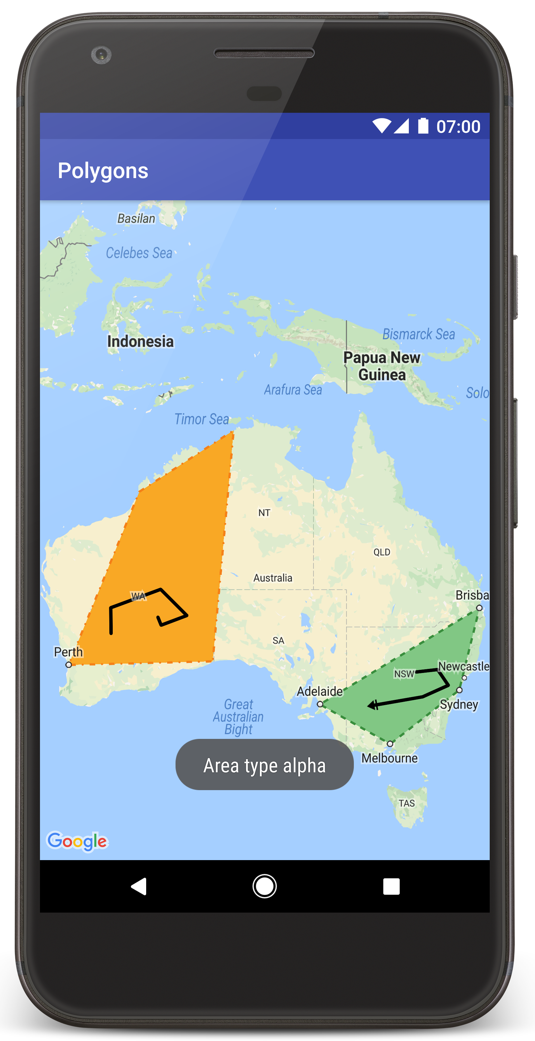
Anda akan melihat peta dengan dua poligon yang ditempatkan di atas Australia, serupa dengan gambar di halaman ini.
Pemecahan masalah:
- Jika Anda tidak melihat peta, pastikan bahwa Anda telah mendapatkan kunci API dan menambahkannya ke aplikasi, seperti yang dijelaskan di atas. Periksa log Android Monitor di Android Studio untuk melihat pesan error tentang kunci API.
- Gunakan debugger Android Studio untuk melihat log dan melakukan debug pada aplikasi.
Memahami kode
Bagian tutorial ini menjelaskan bagian yang paling signifikan dari aplikasi Polygons untuk membantu Anda memahami cara membangun aplikasi yang serupa.
Memeriksa manifes Android
Perhatikan elemen berikut di file AndroidManifest.xml aplikasi Anda:
Tambahkan elemen
meta-datauntuk menyematkan versi layanan Google Play yang digunakan untuk mengompilasi aplikasi.<meta-data android:name="com.google.android.gms.version" android:value="@integer/google_play_services_version" />Tambahkan elemen
meta-datayang menentukan kunci API Anda. Contoh yang disertakan dalam tutorial ini memetakan nilai untuk kunci API ke variabel build yang cocok dengan nama kunci yang Anda tentukan sebelumnya,MAPS_API_KEY. Saat Anda membuat aplikasi, Plugin Secrets Gradle untuk Android akan menyediakan kunci tersebut sebagai variabel build manifes di filelocal.propertiesAnda.<meta-data android:name="com.google.android.geo.API_KEY" android:value="${MAPS_API_KEY}" />Di file
build.gradle, baris berikut akan meneruskan kunci API ke manifes Android Anda.id 'com.google.android.libraries.mapsplatform.secrets-gradle-plugin'
Berikut adalah contoh lengkap manifes:
<?xml version="1.0" encoding="utf-8"?>
<!--
Copyright 2020 Google LLC
Licensed under the Apache License, Version 2.0 (the "License");
you may not use this file except in compliance with the License.
You may obtain a copy of the License at
http://www.apache.org/licenses/LICENSE-2.0
Unless required by applicable law or agreed to in writing, software
distributed under the License is distributed on an "AS IS" BASIS,
WITHOUT WARRANTIES OR CONDITIONS OF ANY KIND, either express or implied.
See the License for the specific language governing permissions and
limitations under the License.
-->
<manifest xmlns:android="http://schemas.android.com/apk/res/android">
<application
android:allowBackup="true"
android:icon="@mipmap/ic_launcher"
android:label="@string/app_name"
android:supportsRtl="true"
android:theme="@style/AppTheme">
<meta-data
    android:name="com.google.android.gms.version"
    android:value="@integer/google_play_services_version" />
<!--
The API key for Google Maps-based APIs.
-->
<meta-data
  android:name="com.google.android.geo.API_KEY"
  android:value="${MAPS_API_KEY}" />
<activity
android:name="com.example.polygons.PolyActivity"
android:exported="true"
android:label="@string/title_activity_maps">
<intent-filter>
<action android:name="android.intent.action.MAIN" />
<category android:name="android.intent.category.LAUNCHER" />
</intent-filter>
</activity>
</application>
</manifest>
Menambahkan peta
Tampilkan peta, menggunakan Maps SDK for Android.
Tambahkan elemen
<fragment>ke file tata letak aktivitas Anda,activity_maps.xml. Elemen ini menentukanSupportMapFragmentagar berfungsi sebagai penampung untuk peta dan untuk memberikan akses ke objekGoogleMap. Tutorial ini menggunakan fragmen peta versi Android Support Library untuk memastikan kompatibilitas mundur dengan framework Android versi lama.<!-- Copyright 2020 Google LLC Licensed under the Apache License, Version 2.0 (the "License"); you may not use this file except in compliance with the License. You may obtain a copy of the License at http://www.apache.org/licenses/LICENSE-2.0 Unless required by applicable law or agreed to in writing, software distributed under the License is distributed on an "AS IS" BASIS, WITHOUT WARRANTIES OR CONDITIONS OF ANY KIND, either express or implied. See the License for the specific language governing permissions and limitations under the License. --> <fragment xmlns:android="http://schemas.android.com/apk/res/android" xmlns:tools="http://schemas.android.com/tools" android:id="@+id/map" android:name="com.google.android.gms.maps.SupportMapFragment" android:layout_width="match_parent" android:layout_height="match_parent" tools:context="com.example.polygons.PolyActivity" />Dalam metode
onCreate()aktivitas, tetapkan file tata letak sebagai tampilan konten. Dapatkan handle ke fragmen peta dengan memanggilFragmentManager.findFragmentById(). Selanjutnya, gunakangetMapAsync()untuk mendaftarkan callback peta:Java
@Override protected void onCreate(Bundle savedInstanceState) { super.onCreate(savedInstanceState); // Retrieve the content view that renders the map. setContentView(R.layout.activity_maps); // Get the SupportMapFragment and request notification when the map is ready to be used. SupportMapFragment mapFragment = (SupportMapFragment) getSupportFragmentManager() .findFragmentById(R.id.map); mapFragment.getMapAsync(this); }Kotlin
override fun onCreate(savedInstanceState: Bundle?) { super.onCreate(savedInstanceState) // Retrieve the content view that renders the map. setContentView(R.layout.activity_maps) // Get the SupportMapFragment and request notification when the map is ready to be used. val mapFragment = supportFragmentManager .findFragmentById(R.id.map) as SupportMapFragment? mapFragment?.getMapAsync(this) }Terapkan antarmuka
OnMapReadyCallbackdan ganti metodeonMapReady(). API memanggil callback ini jika objekGoogleMaptersedia, sehingga Anda dapat menambahkan objek ke peta dan menyesuaikannya lebih lanjut untuk aplikasi:Java
public class PolyActivity extends AppCompatActivity implements OnMapReadyCallback, GoogleMap.OnPolylineClickListener, GoogleMap.OnPolygonClickListener { @Override protected void onCreate(Bundle savedInstanceState) { super.onCreate(savedInstanceState); // Retrieve the content view that renders the map. setContentView(R.layout.activity_maps); // Get the SupportMapFragment and request notification when the map is ready to be used. SupportMapFragment mapFragment = (SupportMapFragment) getSupportFragmentManager() .findFragmentById(R.id.map); mapFragment.getMapAsync(this); } /** * Manipulates the map when it's available. * The API invokes this callback when the map is ready to be used. * This is where we can add markers or lines, add listeners or move the camera. * In this tutorial, we add polylines and polygons to represent routes and areas on the map. */ @Override public void onMapReady(GoogleMap googleMap) { // Add polylines to the map. // Polylines are useful to show a route or some other connection between points. Polyline polyline1 = googleMap.addPolyline(new PolylineOptions() .clickable(true) .add( new LatLng(-35.016, 143.321), new LatLng(-34.747, 145.592), new LatLng(-34.364, 147.891), new LatLng(-33.501, 150.217), new LatLng(-32.306, 149.248), new LatLng(-32.491, 147.309))); // Position the map's camera near Alice Springs in the center of Australia, // and set the zoom factor so most of Australia shows on the screen. googleMap.moveCamera(CameraUpdateFactory.newLatLngZoom(new LatLng(-23.684, 133.903), 4)); // Set listeners for click events. googleMap.setOnPolylineClickListener(this); googleMap.setOnPolygonClickListener(this); }Kotlin
class PolyActivity : AppCompatActivity(), OnMapReadyCallback, OnPolylineClickListener, OnPolygonClickListener { override fun onCreate(savedInstanceState: Bundle?) { super.onCreate(savedInstanceState) // Retrieve the content view that renders the map. setContentView(R.layout.activity_maps) // Get the SupportMapFragment and request notification when the map is ready to be used. val mapFragment = supportFragmentManager .findFragmentById(R.id.map) as SupportMapFragment? mapFragment?.getMapAsync(this) } /** * Manipulates the map when it's available. * The API invokes this callback when the map is ready to be used. * This is where we can add markers or lines, add listeners or move the camera. * In this tutorial, we add polylines and polygons to represent routes and areas on the map. */ override fun onMapReady(googleMap: GoogleMap) { // Add polylines to the map. // Polylines are useful to show a route or some other connection between points. val polyline1 = googleMap.addPolyline(PolylineOptions() .clickable(true) .add( LatLng(-35.016, 143.321), LatLng(-34.747, 145.592), LatLng(-34.364, 147.891), LatLng(-33.501, 150.217), LatLng(-32.306, 149.248), LatLng(-32.491, 147.309))) // Position the map's camera near Alice Springs in the center of Australia, // and set the zoom factor so most of Australia shows on the screen. googleMap.moveCamera(CameraUpdateFactory.newLatLngZoom(LatLng(-23.684, 133.903), 4f)) // Set listeners for click events. googleMap.setOnPolylineClickListener(this) googleMap.setOnPolygonClickListener(this) }
Menambahkan polyline untuk menggambar garis pada peta
Polyline adalah rangkaian segmen garis yang terhubung. Polyline berguna untuk merepresentasikan rute, jalur, atau hubungan lain di antara beberapa lokasi pada peta.
Buat objek
PolylineOptionsdan tambahkan titik ke objek tersebut. Setiap titik merepresentasikan lokasi pada peta, yang Anda tentukan dengan objekLatLngyang berisi nilai lintang dan bujur. Contoh kode di bawah membuat polyline dengan 6 titik.Panggil
GoogleMap.addPolyline()untuk menambahkan polyline ke peta.Java
Polyline polyline1 = googleMap.addPolyline(new PolylineOptions() .clickable(true) .add( new LatLng(-35.016, 143.321), new LatLng(-34.747, 145.592), new LatLng(-34.364, 147.891), new LatLng(-33.501, 150.217), new LatLng(-32.306, 149.248), new LatLng(-32.491, 147.309)));Kotlin
val polyline1 = googleMap.addPolyline(PolylineOptions() .clickable(true) .add( LatLng(-35.016, 143.321), LatLng(-34.747, 145.592), LatLng(-34.364, 147.891), LatLng(-33.501, 150.217), LatLng(-32.306, 149.248), LatLng(-32.491, 147.309)))
Tetapkan opsi clickable polyline ke true jika ingin menangani peristiwa klik pada polyline. Ada penjelasan lainnya tentang penanganan peristiwa nanti dalam tutorial ini.
Menyimpan data arbitrer dengan polyline
Anda dapat menyimpan objek data arbitrer dengan polyline dan objek geometri lainnya.
Panggil
Polyline.setTag()untuk menyimpan objek data dengan polyline. Kode di bawah menentukan tag arbitrer (A) yang menunjukkan jenis polyline.Java
Polyline polyline1 = googleMap.addPolyline(new PolylineOptions()
    .clickable(true)
    .add(
            new LatLng(-35.016, 143.321),
            new LatLng(-34.747, 145.592),
            new LatLng(-34.364, 147.891),
            new LatLng(-33.501, 150.217),
            new LatLng(-32.306, 149.248),
            new LatLng(-32.491, 147.309)));
// Store a data object with the polyline, used here to indicate an arbitrary type.
polyline1.setTag("A");
Kotlin
val polyline1 = googleMap.addPolyline(PolylineOptions()
.clickable(true)
.add(
    LatLng(-35.016, 143.321),
    LatLng(-34.747, 145.592),
    LatLng(-34.364, 147.891),
    LatLng(-33.501, 150.217),
    LatLng(-32.306, 149.248),
    LatLng(-32.491, 147.309)))
// Store a data object with the polyline, used here to indicate an arbitrary type.
polyline1.tag = "A
Ambil data menggunakan
Polyline.getTag(), seperti yang ditunjukkan pada bagian berikutnya.
Menambahkan gaya visual kustom ke polyline
Anda dapat menentukan berbagai properti gaya visual dalam
objek PolylineOptions. Opsi gaya visual mencakup warna goresan, lebar goresan, pola goresan, jenis sambungan, serta ujung awal dan akhir garis. Jika Anda tidak menentukan properti tertentu, API akan menggunakan default untuk properti tersebut.
Kode berikut menerapkan ujung bundar ke akhir garis, dan ujung awal yang berbeda akan bergantung pada jenis polyline, dengan jenis properti arbitrer disimpan dalam objek data untuk polyline. Contoh ini juga menetapkan lebar goresan, warna goresan, dan jenis sambungan:
Java
private static final int COLOR_BLACK_ARGB = 0xff000000;
private static final int POLYLINE_STROKE_WIDTH_PX = 12;
/**
* Styles the polyline, based on type.
* @param polyline The polyline object that needs styling.
*/
private void stylePolyline(Polyline polyline) {
String type = "";
// Get the data object stored with the polyline.
if (polyline.getTag() != null) {
type = polyline.getTag().toString();
}
switch (type) {
// If no type is given, allow the API to use the default.
case "A":
// Use a custom bitmap as the cap at the start of the line.
polyline.setStartCap(
new CustomCap(
BitmapDescriptorFactory.fromResource(R.drawable.ic_arrow), 10));
break;
case "B":
// Use a round cap at the start of the line.
polyline.setStartCap(new RoundCap());
break;
}
polyline.setEndCap(new RoundCap());
polyline.setWidth(POLYLINE_STROKE_WIDTH_PX);
polyline.setColor(COLOR_BLACK_ARGB);
polyline.setJointType(JointType.ROUND);
}
Kotlin
private val COLOR_BLACK_ARGB = -0x1000000
private val POLYLINE_STROKE_WIDTH_PX = 12
/**
* Styles the polyline, based on type.
* @param polyline The polyline object that needs styling.
*/
private fun stylePolyline(polyline: Polyline) {
// Get the data object stored with the polyline.
val type = polyline.tag?.toString() ?: ""
when (type) {
"A" -> {
// Use a custom bitmap as the cap at the start of the line.
polyline.startCap = CustomCap(
BitmapDescriptorFactory.fromResource(R.drawable.ic_arrow), 10f)
}
"B" -> {
// Use a round cap at the start of the line.
polyline.startCap = RoundCap()
}
}
polyline.endCap = RoundCap()
polyline.width = POLYLINE_STROKE_WIDTH_PX.toFloat()
polyline.color = COLOR_BLACK_ARGB
polyline.jointType = JointType.ROUND
}
Kode di atas menentukan bitmap kustom untuk ujung awal polyline jenis A, dan menetapkan lebar goresan referensi sebesar 10 piksel. API menskalakan bitmap berdasarkan lebar goresan referensi. Saat menentukan lebar goresan referensi, berikan lebar yang digunakan saat mendesain gambar bitmap, pada dimensi asli gambar. Petunjuk: Buka gambar bitmap dengan perbesaran 100% dalam editor gambar, dan buat lebar goresan garis yang diinginkan yang sesuai dengan gambar tersebut.
Baca selengkapnya tentang ujung garis dan opsi lainnya untuk menyesuaikan bentuk.
Menangani peristiwa klik pada polyline
Buat polyline yang dapat diklik dengan memanggil
Polyline.setClickable(). (Secara default, polyline tidak dapat diklik dan aplikasi Anda tidak akan menerima notifikasi saat pengguna mengetuk polyline.)Terapkan antarmuka
OnPolylineClickListenerdan panggilGoogleMap.setOnPolylineClickListener()untuk menetapkan pemroses pada peta:Java
public class PolyActivity extends AppCompatActivity implements OnMapReadyCallback, GoogleMap.OnPolylineClickListener, GoogleMap.OnPolygonClickListener { @Override protected void onCreate(Bundle savedInstanceState) { super.onCreate(savedInstanceState); // Retrieve the content view that renders the map. setContentView(R.layout.activity_maps); // Get the SupportMapFragment and request notification when the map is ready to be used. SupportMapFragment mapFragment = (SupportMapFragment) getSupportFragmentManager() .findFragmentById(R.id.map); mapFragment.getMapAsync(this); } /** * Manipulates the map when it's available. * The API invokes this callback when the map is ready to be used. * This is where we can add markers or lines, add listeners or move the camera. * In this tutorial, we add polylines and polygons to represent routes and areas on the map. */ @Override public void onMapReady(GoogleMap googleMap) { // Add polylines to the map. // Polylines are useful to show a route or some other connection between points. Polyline polyline1 = googleMap.addPolyline(new PolylineOptions() .clickable(true) .add( new LatLng(-35.016, 143.321), new LatLng(-34.747, 145.592), new LatLng(-34.364, 147.891), new LatLng(-33.501, 150.217), new LatLng(-32.306, 149.248), new LatLng(-32.491, 147.309))); // Position the map's camera near Alice Springs in the center of Australia, // and set the zoom factor so most of Australia shows on the screen. googleMap.moveCamera(CameraUpdateFactory.newLatLngZoom(new LatLng(-23.684, 133.903), 4)); // Set listeners for click events. googleMap.setOnPolylineClickListener(this); googleMap.setOnPolygonClickListener(this); }Kotlin
class PolyActivity : AppCompatActivity(), OnMapReadyCallback, OnPolylineClickListener, OnPolygonClickListener { override fun onCreate(savedInstanceState: Bundle?) { super.onCreate(savedInstanceState) // Retrieve the content view that renders the map. setContentView(R.layout.activity_maps) // Get the SupportMapFragment and request notification when the map is ready to be used. val mapFragment = supportFragmentManager .findFragmentById(R.id.map) as SupportMapFragment? mapFragment?.getMapAsync(this) } /** * Manipulates the map when it's available. * The API invokes this callback when the map is ready to be used. * This is where we can add markers or lines, add listeners or move the camera. * In this tutorial, we add polylines and polygons to represent routes and areas on the map. */ override fun onMapReady(googleMap: GoogleMap) { // Add polylines to the map. // Polylines are useful to show a route or some other connection between points. val polyline1 = googleMap.addPolyline(PolylineOptions() .clickable(true) .add( LatLng(-35.016, 143.321), LatLng(-34.747, 145.592), LatLng(-34.364, 147.891), LatLng(-33.501, 150.217), LatLng(-32.306, 149.248), LatLng(-32.491, 147.309))) // Position the map's camera near Alice Springs in the center of Australia, // and set the zoom factor so most of Australia shows on the screen. googleMap.moveCamera(CameraUpdateFactory.newLatLngZoom(LatLng(-23.684, 133.903), 4f)) // Set listeners for click events. googleMap.setOnPolylineClickListener(this) googleMap.setOnPolygonClickListener(this) }Ganti metode callback
onPolylineClick(). Contoh berikut mengubah pola goresan garis antara padat dan putus-putus, setiap kali pengguna mengklik polyline:Java
private static final int PATTERN_GAP_LENGTH_PX = 20; private static final PatternItem DOT = new Dot(); private static final PatternItem GAP = new Gap(PATTERN_GAP_LENGTH_PX); // Create a stroke pattern of a gap followed by a dot. private static final List<PatternItem> PATTERN_POLYLINE_DOTTED = Arrays.asList(GAP, DOT); /** * Listens for clicks on a polyline. * @param polyline The polyline object that the user has clicked. */ @Override public void onPolylineClick(Polyline polyline) { // Flip from solid stroke to dotted stroke pattern. if ((polyline.getPattern() == null) || (!polyline.getPattern().contains(DOT))) { polyline.setPattern(PATTERN_POLYLINE_DOTTED); } else { // The default pattern is a solid stroke. polyline.setPattern(null); } Toast.makeText(this, "Route type " + polyline.getTag().toString(), Toast.LENGTH_SHORT).show(); }Kotlin
private val PATTERN_GAP_LENGTH_PX = 20 private val DOT: PatternItem = Dot() private val GAP: PatternItem = Gap(PATTERN_GAP_LENGTH_PX.toFloat()) // Create a stroke pattern of a gap followed by a dot. private val PATTERN_POLYLINE_DOTTED = listOf(GAP, DOT) /** * Listens for clicks on a polyline. * @param polyline The polyline object that the user has clicked. */ override fun onPolylineClick(polyline: Polyline) { // Flip from solid stroke to dotted stroke pattern. if (polyline.pattern == null || !polyline.pattern!!.contains(DOT)) { polyline.pattern = PATTERN_POLYLINE_DOTTED } else { // The default pattern is a solid stroke. polyline.pattern = null } Toast.makeText(this, "Route type " + polyline.tag.toString(), Toast.LENGTH_SHORT).show() }
Menambahkan poligon untuk merepresentasikan area di peta
Polygon adalah bentuk yang terdiri dari rangkaian koordinat yang berurutan, mirip dengan Polyline. Perbedaannya adalah bahwa poligon menentukan area tertutup dengan interior yang dapat diisi, sementara polyline terbuka.
Buat objek
PolygonOptionsdan tambahkan titik ke objek tersebut. Setiap titik merepresentasikan lokasi pada peta, yang Anda tentukan dengan objekLatLngyang berisi nilai lintang dan bujur. Contoh kode berikut membuat poligon dengan 4 titik.Buat poligon yang dapat diklik dengan memanggil
Polygon.setClickable(). (Secara default, poligon tidak dapat diklik dan aplikasi Anda tidak akan menerima notifikasi saat pengguna mengetuk poligon.) Menangani peristiwa klik poligon mirip dengan menangani peristiwa pada polyline, yang dijelaskan sebelumnya dalam tutorial ini.Panggil
GoogleMap.addPolygon()untuk menambahkan poligon ke peta.Panggil
Polygon.setTag()untuk menyimpan objek data dengan poligon. Kode di bawah menetapkan jenis arbitrer (alpha) untuk poligon.Java
// Add polygons to indicate areas on the map. Polygon polygon1 = googleMap.addPolygon(new PolygonOptions() .clickable(true) .add( new LatLng(-27.457, 153.040), new LatLng(-33.852, 151.211), new LatLng(-37.813, 144.962), new LatLng(-34.928, 138.599))); // Store a data object with the polygon, used here to indicate an arbitrary type. polygon1.setTag("alpha");Kotlin
// Add polygons to indicate areas on the map. val polygon1 = googleMap.addPolygon(PolygonOptions() .clickable(true) .add( LatLng(-27.457, 153.040), LatLng(-33.852, 151.211), LatLng(-37.813, 144.962), LatLng(-34.928, 138.599))) // Store a data object with the polygon, used here to indicate an arbitrary type. polygon1.tag = "alpha" // Style the polygon.
Menambahkan gaya visual kustom ke poligon
Anda dapat menentukan sejumlah properti gaya visual dalam
objek PolygonOptions. Opsi gaya visual meliputi warna goresan, lebar goresan, pola goresan, jenis sambungan goresan, dan warna isian. Jika Anda tidak menentukan properti tertentu, API akan menggunakan default untuk properti tersebut.
Kode berikut menerapkan warna dan pola goresan tertentu, bergantung pada jenis poligon, dengan jenis tersebut adalah properti arbitrer yang disimpan dalam objek data untuk poligon tersebut:
Java
private static final int COLOR_WHITE_ARGB = 0xffffffff;
private static final int COLOR_DARK_GREEN_ARGB = 0xff388E3C;
private static final int COLOR_LIGHT_GREEN_ARGB = 0xff81C784;
private static final int COLOR_DARK_ORANGE_ARGB = 0xffF57F17;
private static final int COLOR_LIGHT_ORANGE_ARGB = 0xffF9A825;
private static final int POLYGON_STROKE_WIDTH_PX = 8;
private static final int PATTERN_DASH_LENGTH_PX = 20;
private static final PatternItem DASH = new Dash(PATTERN_DASH_LENGTH_PX);
// Create a stroke pattern of a gap followed by a dash.
private static final List<PatternItem> PATTERN_POLYGON_ALPHA = Arrays.asList(GAP, DASH);
// Create a stroke pattern of a dot followed by a gap, a dash, and another gap.
private static final List<PatternItem> PATTERN_POLYGON_BETA =
Arrays.asList(DOT, GAP, DASH, GAP);
/**
* Styles the polygon, based on type.
* @param polygon The polygon object that needs styling.
*/
private void stylePolygon(Polygon polygon) {
String type = "";
// Get the data object stored with the polygon.
if (polygon.getTag() != null) {
type = polygon.getTag().toString();
}
List<PatternItem> pattern = null;
int strokeColor = COLOR_BLACK_ARGB;
int fillColor = COLOR_WHITE_ARGB;
switch (type) {
// If no type is given, allow the API to use the default.
case "alpha":
// Apply a stroke pattern to render a dashed line, and define colors.
pattern = PATTERN_POLYGON_ALPHA;
strokeColor = COLOR_DARK_GREEN_ARGB;
fillColor = COLOR_LIGHT_GREEN_ARGB;
break;
case "beta":
// Apply a stroke pattern to render a line of dots and dashes, and define colors.
pattern = PATTERN_POLYGON_BETA;
strokeColor = COLOR_DARK_ORANGE_ARGB;
fillColor = COLOR_LIGHT_ORANGE_ARGB;
break;
}
polygon.setStrokePattern(pattern);
polygon.setStrokeWidth(POLYGON_STROKE_WIDTH_PX);
polygon.setStrokeColor(strokeColor);
polygon.setFillColor(fillColor);
}
Kotlin
private val COLOR_WHITE_ARGB = -0x1
private val COLOR_DARK_GREEN_ARGB = -0xc771c4
private val COLOR_LIGHT_GREEN_ARGB = -0x7e387c
private val COLOR_DARK_ORANGE_ARGB = -0xa80e9
private val COLOR_LIGHT_ORANGE_ARGB = -0x657db
private val POLYGON_STROKE_WIDTH_PX = 8
private val PATTERN_DASH_LENGTH_PX = 20
private val DASH: PatternItem = Dash(PATTERN_DASH_LENGTH_PX.toFloat())
// Create a stroke pattern of a gap followed by a dash.
private val PATTERN_POLYGON_ALPHA = listOf(GAP, DASH)
// Create a stroke pattern of a dot followed by a gap, a dash, and another gap.
private val PATTERN_POLYGON_BETA = listOf(DOT, GAP, DASH, GAP)
/**
* Styles the polygon, based on type.
* @param polygon The polygon object that needs styling.
*/
private fun stylePolygon(polygon: Polygon) {
// Get the data object stored with the polygon.
val type = polygon.tag?.toString() ?: ""
var pattern: List<PatternItem>? = null
var strokeColor = COLOR_BLACK_ARGB
var fillColor = COLOR_WHITE_ARGB
when (type) {
"alpha" -> {
// Apply a stroke pattern to render a dashed line, and define colors.
pattern = PATTERN_POLYGON_ALPHA
strokeColor = COLOR_DARK_GREEN_ARGB
fillColor = COLOR_LIGHT_GREEN_ARGB
}
"beta" -> {
// Apply a stroke pattern to render a line of dots and dashes, and define colors.
pattern = PATTERN_POLYGON_BETA
strokeColor = COLOR_DARK_ORANGE_ARGB
fillColor = COLOR_LIGHT_ORANGE_ARGB
}
}
polygon.strokePattern = pattern
polygon.strokeWidth = POLYGON_STROKE_WIDTH_PX.toFloat()
polygon.strokeColor = strokeColor
polygon.fillColor = fillColor
}
Baca info selengkapnya tentang pola goresan dan opsi lainnya untuk menyesuaikan bentuk.
Langkah berikutnya
Pelajari objek Lingkaran. Lingkaran mirip dengan poligon, tetapi memiliki properti yang menampilkan bentuk lingkaran.