-
北米の土地被覆(30 メートル)、2020 年
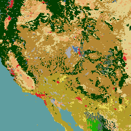
2020 年の北米の土地被覆 30 メートルのデータセットは、カナダ天然資源省、米国地質調査所、メキシコの 3 つの組織(国立統計地理情報院など)による三者間の取り組みである北米の土地変化モニタリング システム(NALCMS)の一環として作成されました。 landcover landsat landuse-landcover nlcd reflectance -
NLCD 2019: USGS National Land Cover Database、2019 年リリース
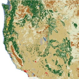
NLCD(National Land Cover Database)は、30 m の Landsat ベースの土地被覆データベースで、8 つのエポック(2001 年、2004 年、2006 年、2008 年、2011 年、2013 年、2016 年、2019 年)にわたっています。2021 年の 9 番目のエポックもこちらで確認できます。画像は、都市の不浸透性データレイヤに依存しています。 blm landcover landuse-landcover mrlc nlcd usgs -
NLCD 2021: USGS National Land Cover Database、2021 年リリース
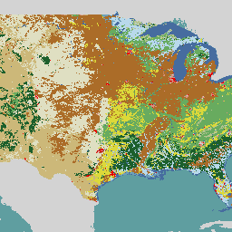
米国地質調査所(USGS)は、複数の連邦機関と提携して、7 つの National Land Cover Database(NLCD)プロダクト(NLCD 1992、2001、2006、2011、2016、2019、2021)を開発し、リリースしました。2016 年のリリース以降、土地被覆プロダクトは 2 ~ 3 年間隔で作成されています。 blm landcover landuse-landcover mrlc nlcd usgs -
RCMAP Rangeland Component Timeseries(1985 ~ 2023 年)、v06

「RCMAP(Rangeland Condition Monitoring Assessment and Projection)データセットは、1985 年から 2023 年の Landsat 画像を使用して、北米西部の牧草地の構成要素の被覆率を定量化します。RCMAP プロダクト スイートは、10 個の分数コンポーネントで構成されています。年間の草本、裸地、草本、リター、セージブラシ以外の低木、多年生の草本、セージブラシなどです。 climate-change disturbance landsat-derived landuse-landcover nlcd rangeland -
RCMAP 牧草地の傾向のコンポーネント時系列の年(1985 ~ 2023 年)、v06

このコレクションには、1985 年から 2023 年までの RCMAP 年次プロダクトが含まれています。RCMAP(Rangeland Condition Monitoring Assessment and Projection)データセットは、1985 年から 2023 年の Landsat 画像を使用して、北米西部の牧草地の構成要素の被覆率を定量化します。RCMAP プロダクト スイートは、10 個のフラクショナル コンポーネントで構成されています。年間の… climate-change disturbance landsat-derived landuse-landcover nlcd rangeland -
RCMAP Rangeland Trends for Component Timeseries(1985 ~ 2023 年)、v06

RCMAP(Rangeland Condition Monitoring Assessment and Projection)データセットは、1985 年から 2023 年の Landsat 画像を使用して、北米西部の牧草地の構成要素の被覆率を定量化します。RCMAP プロダクト スイートは、10 個の分数コンポーネントで構成されています。年間の草本、裸地、草本、リター、セージブラシ以外の低木、多年生の草本、セージブラシなどです。 climate-change disturbance landsat-derived landuse-landcover nlcd rangeland