-
GOES-16 FDCC シリーズ ABI レベル 2 火災/ホットスポットの特性評価(米国本土)

火災(HSC)プロダクトには、火災マスクの形状の画像 1 つと、火災の温度、火災の面積、火災の放射力を示すピクセル値を含む画像 3 つが含まれています。ABI L2+ FHS メタデータ マスクは、地球上を移動したすべてのピクセルにフラグを割り当てます。 abi fdc fire goes goes-16 goes-east -
GOES-16 FDCF シリーズ ABI レベル 2 火災/ホットスポットの特性評価(フルディスク)

火災(HSC)プロダクトには、火災マスクの形状の画像 1 つと、火災の温度、火災の面積、火災の放射力を示すピクセル値を含む画像 3 つが含まれています。ABI L2+ FHS メタデータ マスクは、地球上を移動したすべてのピクセルにフラグを割り当てます。 abi fdc fire goes goes-16 goes-east -
GOES-16 MCMIPC シリーズ ABI レベル 2 雲と湿度の画像(米国本土)
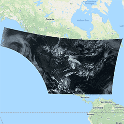
雲と湿度の画像プロダクトはすべて 2 km の解像度です。バンド 1 ~ 6 は反射素材です。無次元の「反射率係数」量は、太陽天頂角で正規化されます。これらのバンドは、雲、植生、雪/氷、エアロゾルの特性評価をサポートしています。バンド 7 ~ 16 は発光型です。明るさの色温度は... abi atmosphere goes goes-16 goes-east goes-r -
GOES-16 MCMIPF シリーズ ABI レベル 2 雲と湿度の画像(フルディスク)
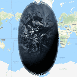
雲と湿度の画像プロダクトはすべて 2 km の解像度です。バンド 1 ~ 6 は反射素材です。無次元の「反射率係数」量は、太陽天頂角で正規化されます。これらのバンドは、雲、植生、雪/氷、エアロゾルの特性評価をサポートしています。バンド 7 ~ 16 は発光型です。明るさの色温度は... abi atmosphere goes goes-16 goes-east goes-r -
GOES-16 MCMIPM シリーズ ABI レベル 2 雲と湿度の画像メソスケール

雲と湿度の画像プロダクトはすべて 2 km の解像度です。バンド 1 ~ 6 は反射素材です。無次元の「反射率係数」量は、太陽天頂角で正規化されます。これらのバンドは、雲、植生、雪/氷、エアロゾルの特性評価をサポートしています。バンド 7 ~ 16 は発光型です。明るさの色温度は... abi atmosphere goes goes-16 goes-east goes-r