-
GOES-16 FDCC シリーズ ABI レベル 2 火災/ホットスポットの特性評価(米国本土)

火災(HSC)プロダクトには、火災マスクの形状の画像 1 つと、火災の温度、火災の面積、火災の放射力を示すピクセル値を含む画像 3 つが含まれています。ABI L2+ FHS メタデータ マスクは、地球上を移動したすべてのピクセルにフラグを割り当てます。 abi fdc fire goes goes-16 goes-east -
GOES-16 FDCF シリーズ ABI レベル 2 火災/ホットスポットの特性評価(フルディスク)

火災(HSC)プロダクトには、火災マスクの形状の画像 1 つと、火災の温度、火災の面積、火災の放射力を示すピクセル値を含む画像 3 つが含まれています。ABI L2+ FHS メタデータ マスクは、地球上を移動したすべてのピクセルにフラグを割り当てます。 abi fdc fire goes goes-16 goes-east -
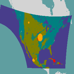
GOES-17 FDCC シリーズ ABI レベル 2 火災/ホットスポットの特性評価(米国本土)

火災(HSC)プロダクトには、火災マスクの形状の画像 1 つと、火災の温度、火災の面積、火災の放射力を示すピクセル値を含む画像 3 つが含まれています。ABI L2+ FHS メタデータ マスクは、地球上を移動したすべてのピクセルにフラグを割り当てます。 abi fdc fire goes goes-17 goes-s -
GOES-17 FDCF シリーズ ABI レベル 2 火災/ホットスポットの特性評価(フルディスク)

火災(HSC)プロダクトには、火災マスクの形状の画像 1 つと、火災の温度、火災の面積、火災の放射力を示すピクセル値を含む画像 3 つが含まれています。ABI L2+ FHS メタデータ マスクは、地球上を移動したすべてのピクセルにフラグを割り当てます。 abi fdc fire goes goes-17 goes-s -
GOES-18 FDCC シリーズ ABI レベル 2 火災/ホットスポットの特性評価(米国本土)

火災(HSC)プロダクトには、火災マスクの形状の画像 1 つと、火災の温度、火災の面積、火災の放射力を示すピクセル値を含む画像 3 つが含まれています。ABI L2+ FHS メタデータ マスクは、地球上を移動したすべてのピクセルにフラグを割り当てます。 abi fdc fire goes goes-18 goes-t -
GOES-18 FDCF シリーズ ABI レベル 2 火災/ホットスポットの特性評価(フルディスク)

火災(HSC)プロダクトには、火災マスクの形状の画像 1 つと、火災の温度、火災の面積、火災の放射力を示すピクセル値を含む画像 3 つが含まれています。ABI L2+ FHS メタデータ マスクは、地球上を移動したすべてのピクセルにフラグを割り当てます。 abi fdc fire goes goes-18 goes-t -
GOES-19 FDCC シリーズ ABI レベル 2 火災/ホットスポットの特性評価(米国本土)
GOES 衛星は、NOAA が運用する静止気象衛星です。火災(HSC)プロダクトには、火災マスクの形状の画像 1 つと、火災の温度、火災の面積、火災の放射力を示すピクセル値を含む画像 3 つが含まれています。ABI L2+ FHS メタデータは... abi fdc fire goes goes-19 goes-east -
GOES-19 FDCF シリーズ ABI レベル 2 火災/ホットスポットの特性評価(フルディスク)

火災(HSC)プロダクトには、火災マスクの形状の画像 1 つと、火災の温度、火災の面積、火災の放射力を示すピクセル値を含む画像 3 つが含まれています。ABI L2+ FHS メタデータ マスクは、地球上を移動したすべてのピクセルにフラグを割り当てます。 abi fdc fire goes goes-19 goes-east