-
GOES-16 FDCC シリーズ ABI レベル 2 火災/ホットスポット特性評価 CONUS

Fire(HSC)プロダクトには 4 つの画像が含まれています。1 つは火災マスクの形式で、残りの 3 つは火災の温度、火災の面積、火災の放射エネルギーを特定するピクセル値が含まれています。ABI L2+ FHS メタデータ マスクは、… abi fdc fire goes goes-16 goes-east -
GOES-16 FDCF シリーズ ABI レベル 2 火災/ホットスポットの特性評価 フルディスク

Fire(HSC)プロダクトには 4 つの画像が含まれています。1 つは火災マスクの形式で、残りの 3 つは火災の温度、火災の面積、火災の放射エネルギーを特定するピクセル値が含まれています。ABI L2+ FHS メタデータ マスクは、… abi fdc fire goes goes-16 goes-east -
GOES-16 MCMIPC シリーズ ABI レベル 2 の雲と水分の画像(米国本土)
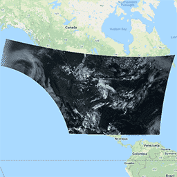
雲と水分の画像プロダクトはすべて 2 km の解像度です。バンド 1 ~ 6 は反射します。無次元の「反射率係数」は太陽天頂角で正規化されます。これらのバンドは、雲、植生、雪氷、エアロゾルの特性評価をサポートしています。バンド 7 ~ 16 は発光性です。輝度温度は … abi atmosphere goes goes-16 goes-east goes-r -
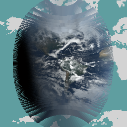
GOES-16 MCMIPF シリーズ ABI レベル 2 雲と水分の画像(全地球)
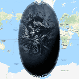
雲と水分の画像プロダクトはすべて 2 km の解像度です。バンド 1 ~ 6 は反射します。無次元の「反射率係数」は太陽天頂角で正規化されます。これらのバンドは、雲、植生、雪氷、エアロゾルの特性評価をサポートしています。バンド 7 ~ 16 は発光性です。輝度温度は … abi atmosphere goes goes-16 goes-east goes-r -
GOES-16 MCMIPM シリーズ ABI レベル 2 の雲と水分の画像メソスケール

雲と水分の画像プロダクトはすべて 2 km の解像度です。バンド 1 ~ 6 は反射します。無次元の「反射率係数」は太陽天頂角で正規化されます。これらのバンドは、雲、植生、雪氷、エアロゾルの特性評価をサポートしています。バンド 7 ~ 16 は発光性です。輝度温度は … abi atmosphere goes goes-16 goes-east goes-r -
GOES-19 FDCC シリーズ ABI レベル 2 火災/ホットスポット特性評価 CONUS
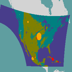
GOES 衛星は、NOAA が運用する静止気象衛星です。Fire(HSC)プロダクトには 4 つの画像が含まれています。1 つは火災マスクの形式で、残りの 3 つは火災の温度、火災の面積、火災の放射エネルギーを特定するピクセル値が含まれています。ABI L2+ FHS メタデータは … abi fdc fire goes goes-19 goes-east -
GOES-19 FDCF シリーズ ABI レベル 2 火災/ホットスポット特性評価フルディスク

Fire(HSC)プロダクトには 4 つの画像が含まれています。1 つは火災マスクの形式で、残りの 3 つは火災の温度、火災の面積、火災の放射エネルギーを特定するピクセル値が含まれています。ABI L2+ FHS メタデータ マスクは、… abi fdc fire goes goes-19 goes-east -
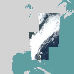
GOES-19 MCMIPC シリーズ ABI レベル 2 雲と水分の画像(米国本土)
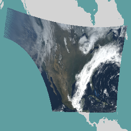
雲と水分の画像プロダクトはすべて 2 km の解像度です。バンド 1 ~ 6 は反射します。無次元の「反射率係数」は太陽天頂角で正規化されます。これらのバンドは、雲、植生、雪氷、エアロゾルの特性評価をサポートしています。バンド 7 ~ 16 は発光性です。輝度温度は … abi atmosphere goes goes-19 goes-east goes-u -
GOES-19 MCMIPF シリーズ ABI レベル 2 雲と水分の画像フルディスク
雲と水分の画像プロダクトはすべて 2 km の解像度です。バンド 1 ~ 6 は反射します。無次元の「反射率係数」は太陽天頂角で正規化されます。これらのバンドは、雲、植生、雪氷、エアロゾルの特性評価をサポートしています。バンド 7 ~ 16 は発光性です。輝度温度は … abi atmosphere goes goes-19 goes-east goes-u -
GOES-19 MCMIPM シリーズ ABI レベル 2 雲と水分の画像メソスケール
雲と水分の画像プロダクトはすべて 2 km の解像度です。バンド 1 ~ 6 は反射します。無次元の「反射率係数」は太陽天頂角で正規化されます。これらのバンドは、雲、植生、雪氷、エアロゾルの特性評価をサポートしています。バンド 7 ~ 16 は発光性です。輝度温度は … abi atmosphere goes goes-19 goes-east goes-u