-
コートジボワール BNETD 2020 年土地被覆地図
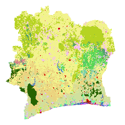
コートジボワール BNETD 2020 土地被覆地図は、コートジボワール政府が、国家機関である国立技術開発研究局の地理情報・デジタル センター(BNETD-CIGN)を通じて作成したもので、欧州連合から技術的および財政的な支援を受けています。方法論 … 分類 森林破壊 森林 土地被覆 土地利用と土地被覆 -
IPCC 地上バイオマス ティア 1 推定値のグローバル 2020 年森林分類、V1
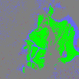
このデータセットは、2020 年のステータス/状態別に分類された世界の森林のクラスを約 30 m の解像度で提供します。このデータは、2006 年の IPCC の国別温室効果ガスインベントリに関するガイドラインの 2019 年の改訂版で、天然林の地上部乾燥木質バイオマス密度(AGBD)のティア 1 推定値を生成するために使用されています。 地上バイオマス バイオマス 炭素 分類 森林 森林バイオマス -
PALSAR-2/PALSAR 森林/非森林のグローバル 3 クラス マップ
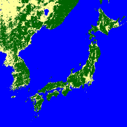
2017 ~ 2020 年の 4 つのクラスを含むこのデータセットの新しいバージョンは、JAXA/ALOS/PALSAR/YEARLY/FNF4 にあります。森林/非森林のグローバル マップ(FNF)は、グローバル 25 m 分解能の PALSAR-2/PALSAR SAR モザイクで SAR 画像(後方散乱係数)を分類して生成されます。これにより、強い後方散乱ピクセルと弱い後方散乱ピクセルが… alos alos2 classification eroc forest forest-biomass -
グローバル 4 クラス PALSAR-2/PALSAR 森林/非森林マップ
森林/非森林グローバル マップ(FNF)は、グローバル 25 m 分解能の PALSAR-2/PALSAR SAR モザイクで SAR 画像(後方散乱係数)を分類し、強い後方散乱ピクセルと弱い後方散乱ピクセルをそれぞれ「森林」と「非森林」として割り当てることで生成されます。ここで「森林」とは、… alos alos2 classification eroc forest forest-biomass