-
GHSL: Global building height 2018(P2023A)
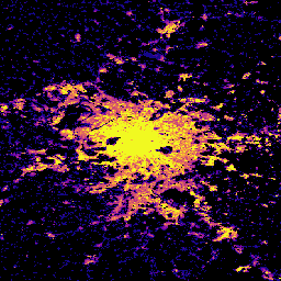
この空間ラスター データセットは、2018 年の建物の高さのグローバル分布を 100 m の解像度で示しています。建物の高さの予測に使用される入力データは、ALOS グローバル デジタル サーフェス モデル(30 m)、NASA スペースシャトル レーダー地形ミッションなどです。 alos building built built-environment builtup copernicus -
GHSL: Global built-up surface 10m(P2023A)
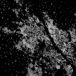
このラスター データセットは、S2 画像データから観測された 2018 年の建物表面の分布を、10 m グリッドセルあたりの平方メートルで表しています。データセットは、a) 総建築面積と、b) … のグリッド セルに割り当てられた建築面積を測定します。 built built-environment builtup copernicus ghsl jrc -
GHSL: Global built-up surface 1975-2030(P2023A)
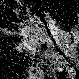
このラスター データセットは、100 m グリッド セルあたりの平方メートルで表される、建物が建っている表面の分布を示しています。このデータセットでは、a) 総建築面積と、b) 主に非住宅(NRES)用途のグリッド セルに割り当てられた建築面積を測定します。データは空間的および時間的に補間されるか、… built built-environment builtup copernicus ghsl jrc -
GHSL: Global settlement characteristics (10 m) 2018(P2023A)
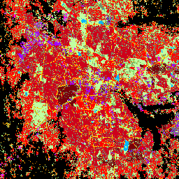
この空間ラスター データセットは、10 m の解像度で人間の居住地を区切り、その内部特性を、構築された環境の機能的および高さ関連のコンポーネントの観点から記述します。GHSL データ プロダクトの詳細については、GHSL Data Package 2023 レポートをご覧ください。 building built builtup copernicus ghsl height -
清華大学の FROM-GLC の変化年と不浸透面
このデータセットには、1985 年から 2018 年までの世界の不浸透性表面積の年間変化に関する情報が 30 m の解像度で含まれています。透水性から不透水性への変化は、教師あり分類と時間的整合性チェックを組み合わせたアプローチを使用して判断されました。不浸透性ピクセルは、不浸透性が 50% を超えるものとして定義されます。… built population tsinghua urban