Page Summary
-
The National Intertidal Digital Elevation Model (NIDEM) provides a continental-scale elevation dataset for Australia's exposed intertidal zone.
-
NIDEM offers the first three-dimensional representation of Australia's intertidal areas at 25 m spatial resolution.
-
The dataset was created using global tidal modeling combined with a 30-year archive of Landsat satellite data.
-
NIDEM includes bands for elevation, a quality mask, uncertainty, and unfiltered elevation.
-
The dataset is available from 1986 to 2017 and is licensed under CC-BY-4.0.
- Dataset Availability
- 1986-08-16T00:00:00Z–2017-07-31T23:59:59Z
- Dataset Producer
- Geoscience Australia
- Dataset Processor
- NGIS
- Tags
Description
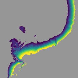
The National Intertidal Digital Elevation Model (NIDEM; Bishop-Taylor et al. 2018, 2019) is a continental-scale elevation dataset for Australia's exposed intertidal zone. NIDEM provides the first three-dimensional representation of Australia's intertidal sandy beaches and shores, tidal flats and rocky shores and reefs at 25 m spatial resolution, addressing a key gap between the availability of sub-tidal bathymetry and terrestrial elevation data. NIDEM was generated by combining global tidal modelling with a 30-year time series archive of spatially and spectrally calibrated Landsat satellite data managed within the Digital Earth Australia (DEA) platform. NIDEM complements existing intertidal extent products, and provides data to support a new suite of use cases that require a more detailed understanding of the three-dimensional topography of the intertidal zone, such as hydrodynamic modelling, coastal risk management and ecological habitat mapping.
For more information, please see the DEA Intertidal Elevation
Bands
Bands
Pixel size: 25 meters (all bands)
| Name | Units | Min | Max | Pixel Size | Description |
|---|---|---|---|---|---|
nidem |
m | -5 | 3.9 | 25 meters | Primary product: elevation in meter units relative to modelled Mean Sea Level (MSL). Band details |
nidem_mask |
25 meters | Quality flag. Band details |
|||
nidem_uncertainty |
m | 0 | 0.3 | 25 meters | Uncertainty meters. Band details |
nidem_unfiltered |
m | -5 | 3.9 | 25 meters | Un-cleaned elevation in meters. Band details |
nidem_mask Class Table
| Value | Color | Description |
|---|---|---|
| 1 | #00ff00 | above 25 m relative to Mean Sea Level (MSL) |
| 2 | #ff0000 | below -25 m relative to Mean Sea Level (MSL) |
| 3 | #ffff00 | invalid elevation estimates |
Terms of Use
Terms of Use
Citations
Bishop-Taylor, R., Sagar, S., Lymburner, L., & Beaman, R. J. (2019). Between the tides: Modelling the elevation of Australia's exposed intertidal zone at continental scale. Estuarine, Coastal and Shelf Science, 223, 115-128. doi:10.1016/j.ecss.2019.03.006
DOIs
Explore with Earth Engine
Code Editor (JavaScript)
var nidem = ee.Image('projects/ngis-cat/assets/DEA/NIDEM');

var elevation = nidem.select('nidem');
var elevationVis = {
  min: -2.5,
  max: 1.5,
  palette: [
    '440154', '471365', '482475', '463480', '414487', '3b528b', '355f8d',
    '2f6c8e', '2a788e', '25848e', '21918c', '1e9c89', '22a884', '2fb47c',
    '44bf70', '5ec962', '7ad151', '9bd93c', 'bddf26', 'dfe318', 'fde725'
  ],
};
Map.setCenter(122.36, -18.10, 11);
Map.addLayer(
    elevation, elevationVis,
    'National Intertidal Digital Elevation Model (NIDEM; m)');