Page Summary
-
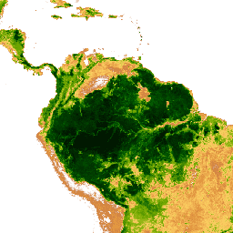
This dataset provides a national-level map of above-ground live woody biomass density for tropical countries at 500m resolution.
-
The dataset was created using a combination of field measurements, LiDAR observations, and MODIS imagery.
-
The dataset is available for use for scientific, conservation, and educational purposes.
-
The data band
Mgrepresents Megagrams of aboveground live woody biomass per Hectare.
- Dataset Availability
- 2012-01-29T00:00:00Z–2012-01-29T00:00:00Z
- Dataset Producer
- WHRC
- Tags
Description
A national-level map of above-ground live woody biomass density for tropical countries at 500m. This dataset was assembled from a combination of co-located field measurements, LiDAR observations, and imagery recorded from the Moderate Resolution Imaging Spectroradiometer (MODIS).
Bands
Pixel Size
500 meters
Bands
| Name | Units | Min | Max | Pixel Size | Description |
|---|---|---|---|---|---|
Mg |
Mg/ha | 0* | 503* | meters | Megagrams of aboveground live woody biomass per Hectare |
Terms of Use
Terms of Use
- The national level dataset is freely available for use for scientific, conservation, and educational purposes.
- Users acknowledge that they themselves are responsible for determining whether the dataset is of sufficient quality and appropriateness for their objectives.
- Users agree that they will make reasonable efforts to provide appropriate feedbacks and notification of any significant errors that they identify in the dataset.
Citations
A. Baccini, S J. Goetz, W.S. Walker, N. T. Laporte, M. Sun, D. Sulla-Menashe, J. Hackler, P.S.A. Beck, R. Dubayah, M.A. Friedl, S. Samanta and R. A. Houghton. Estimated carbon dioxide emissions from tropical deforestation improved by carbon-density maps. 2012 Nature Climate Change, doi:10.1038/NCLIMATE1354
Explore with Earth Engine
Code Editor (JavaScript)
var dataset = ee.Image('WHRC/biomass/tropical');
// Show results only over land.
var landMask = ee.Image('NOAA/NGDC/ETOPO1').select('bedrock').gt(0);
var liveWoodyBiomass = dataset.updateMask(landMask);

var visParams = {
  min: 0,
  max: 350,
  palette: [
    'ffffff', 'ce7e45', 'df923d', 'f1b555', 'fcd163', '99b718', '74a901',
    '66a000', '529400', '3e8601', '207401', '056201', '004c00', '023b01',
    '012e01', '011d01', '011301'
  ],
};
Map.addLayer(
    liveWoodyBiomass, visParams, 'Aboveground Live Woody Biomass (Mg/ha)');

Map.setCenter(-69.4, 0.3, 3);
Map.setOptions('SATELLITE');