Page Summary
-
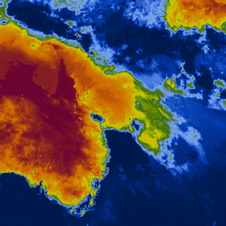
The Keetch-Byram Drought Index (KBDI) is a continuous scale used for estimating soil and duff layer dryness.
-
KBDI increases with dry days and temperature, and decreases with rain, reflecting meteorological drought.
-
The scale ranges from 0 (no moisture deficit) to 800 (extreme drought) based on available soil moisture.
-
KBDI is widely used globally for drought monitoring, wildfire prevention, and supporting rain-fed crops.
- Dataset Availability
- 2007-01-01T00:00:00Z–2026-07-26T00:00:00Z
- Dataset Producer
- Institute of Industrial Science, The University of Tokyo, Japan
- Cadence
- 1 Day
- Tags
Description
Keetch-Byram Drought Index (KBDI) is a continuous reference scale for estimating the dryness of the soil and duff layers. The index increases for each day without rain (the amount of increase depends on the daily high temperature) and decreases when it rains. This system is based primarily on recent rainfall patterns. It is a measure of meteorological drought; it reflects water gain or loss within the soil.
The scale ranges from 0 (no moisture deficit) to 800 (extreme drought). The range of the index is determined by assuming that there is 20 cm of moisture in a saturated soil that is readily available to the vegetation (Keetch and Byram, 1968). KBDI is world widely used for drought monitoring for national weather forecast, wildfire prevention and usefully especially in regions with rain-fed crops.
Bands
Bands
Pixel size: 4000 meters (all bands)
| Name | Min | Max | Pixel Size | Description |
|---|---|---|---|---|
KBDI |
0 | 800 | 4000 meters | Keetch-Byram Drought Index |
Terms of Use
Terms of Use
Citations
Wataru Takeuchi, Soni Darmawan, Rizatus Shofiyati, Mai Van Khiem, Kyaw San Oo, Uday Pimple and Suthy Heng, 2015. Near-real time meteorological drought monitoring and early warning system for croplands in Asia. 36th Asian conference on remote sensing (ACRS): Manila, Philippines, Oct. 20, 2015.
Explore with Earth Engine
Code Editor (JavaScript)
var collection = ee.ImageCollection('UTOKYO/WTLAB/KBDI/v1')
  .select('KBDI')
  .filterDate('2019-01-01', '2019-01-10');
var bandViz = {
  min: 0,
  max: 800,
  palette: [
    '001a4d', '003cb3', '80aaff', '336600', 'cccc00', 'cc9900', 'cc6600',
    '660033'
  ]
};
Map.addLayer(collection.mean(), bandViz, 'Keetch-Byram Drought Index');
Map.setCenter(120, 3, 3);