Page Summary
-
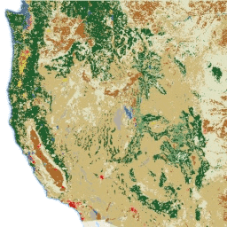
This dataset, the NLCD 2016 release, is a 30-m Landsat-based land cover database covering the United States from 1992 to 2016 across eight epochs.
-
The dataset includes land cover classification, imperviousness, percent tree cover, and specific rangeland characteristics for the Western United States in 2016.
-
Data is available for the continental US, with separate images for Alaska, Hawaii, and Puerto Rico in specific years due to differing projections.
-
This dataset is partially superseded by the newer USGS/NLCD_RELEASES/2019_REL/NLCD dataset for landcover and imperviousness data.
- Dataset Availability
- 1992-01-01T00:00:00Z–2017-01-01T00:00:00Z
- Dataset Producer
- USGS
- Tags
Description
This dataset is partially superseded by newer datasets:
- Landcover and imperviousness data in USGS/NLCD_RELEASES/2019_REL/NLCD.
NLCD (the National Land Cover Database) is a 30-m Landsat-based land cover database spanning 8 epochs (1992, 2001, 2004, 2006, 2008, 2011, 2013 and 2016). 1992 data are primarily based on unsupervised classification of Landsat data, while the rest of the images rely on the imperviousness data layer for the urban classes and on a decision-tree classification for the rest. The 1992 image is not directly comparable to any later editions of NLCD.
This dataset has one image for the continental US for each of the eight epochs, plus separate images for Alaska, Hawaii, and Puerto Rico in 2001, 2011, and 2016. (They could not be merged in due to having a different projection from the continental US images.)
Note that the impervious layers and tree cover layers for Alaska 2011 only have data for parts of Alaska. For the impervious layer, only the parts of Kenai Peninsula Borough and Anchorage Municipality are available. Tree cover is only available on a strip along the coast from the southern tip of the Alaskan Panhandle up through the Kenai Peninsula, plus Kodiak Island.
NLCD 2016 Rangeland Component products characterize the percentage of each 30-meter pixel in the Western United States covered by shrub, herbaceous, bare ground, litter, sagebrush, big sagebrush and annual herbaceous, along with estimating shrub height and sagebrush height. These products have been produced by USGS in collaboration with the Bureau of Land Management.
NLCD products are created by the Multi-Resolution Land Characteristics (MRLC) Consortium, a partnership of federal agencies led by the U.S. Geological Survey.
Bands
Bands
Pixel size: 30 meters (all bands)
| Name | Units | Min | Max | Pixel Size | Description |
|---|---|---|---|---|---|
landcover |
0 | 95 | 30 meters | All images except 2011_HI, 2011_PR, 2016_HI, and 2016_PR include the landcover classification scheme described in the 2016 Product Legend. The legends are also available as metadata on each image. The classes in the 2016 product legend are given below. |
|
impervious |
% | 0 | 100 | 30 meters | Percent of the pixel covered by developed impervious surface. Included in images 2001, 2001_AK, 2001_HI, 2001_PR, 2006, 2011, 2011_AK, 2016, and 2016_AK. |
impervious_descriptor |
30 meters | Defines which impervious layer pixels are roads and provides the best fit description for impervious pixels that are not roads. Included in images 2001, 2001_AK, 2006, 2011, 2016, and 2016_AK. |
|||
urban_descriptor |
30 meters | The developed urban descriptor (Alaska) represents delineation of the layers that were combined to create develop features where an impervious estimate was not able to be initialized. This additional layer gives description that is identical to the impervious descriptor. Included in images 2001_AK, 2011_AK, and 2016_AK. |
|||
percent_tree_cover |
% | 0 | 100 | 30 meters | Percent of the pixel that's covered by tree canopy. No masking of obvious non-tree areas is performed for this product. Included in images 2011, 2011_AK, 2011_HI, 2011_PR, 2016, 2016_AK, 2016_HI, and 2016_PR. |
rangeland_annual_herbaceous |
% | 0 | 100 | 30 meters | The annual only grass and forb proportion in each in 30m pixel. Included in 2016. |
rangeland_bare_ground |
% | 0 | 100 | 30 meters | The bare ground proportion in each 30m pixel. Included in 2016. |
rangeland_big_sagebrush |
% | 0 | 100 | 30 meters | The proportion of big sagebrush canopy in each 30m pixel. Included in 2016. |
rangeland_herbaceous |
% | 0 | 100 | 30 meters | The annual and perennial grass and forb proportion in each 30m pixel. Included in 2016. |
rangeland_litter |
% | 0 | 100 | 30 meters | The dead plant material proportion in each 30m pixel. Included in 2016. |
rangeland_sagebrush |
% | 0 | 100 | 30 meters | The proportion of sagebrush canopy in each 30m pixel. Included in 2016. |
rangeland_sagebrush_height |
cm | 0 | 997 | 30 meters | Average height of sagebrush. Included in 2016. |
rangeland_shrub |
% | 0 | 100 | 30 meters | The proportion of shrub canopy in each 30m pixel. Included in 2016. |
rangeland_shrub_height |
cm | 0 | 997 | 30 meters | Average height of shrubs. Included in 2016. |
landcover Class Table
| Value | Color | Description |
|---|---|---|
| 11 | #466b9f | Open water: areas of open water, generally with less than 25% cover of vegetation or soil. |
| 12 | #d1def8 | Perennial ice/snow: areas characterized by a perennial cover of ice and/or snow, generally greater than 25% of total cover. |
| 21 | #dec5c5 | Developed, open space: areas with a mixture of some constructed materials, but mostly vegetation in the form of lawn grasses. Impervious surfaces account for less than 20% of total cover. These areas most commonly include large-lot single-family housing units, parks, golf courses, and vegetation planted in developed settings for recreation, erosion control, or aesthetic purposes. |
| 22 | #d99282 | Developed, low intensity: areas with a mixture of constructed materials and vegetation. Impervious surfaces account for 20% to 49% percent of total cover. These areas most commonly include single-family housing units. |
| 23 | #eb0000 | Developed, medium intensity: areas with a mixture of constructed materials and vegetation. Impervious surfaces account for 50% to 79% of the total cover. These areas most commonly include single-family housing units. |
| 24 | #ab0000 | Developed high intensity: highly developed areas where people reside or work in high numbers. Examples include apartment complexes, row houses, and commercial/industrial. Impervious surfaces account for 80% to 100% of the total cover. |
| 31 | #b3ac9f | Barren land (rock/sand/clay): areas of bedrock, desert pavement, scarps, talus, slides, volcanic material, glacial debris, sand dunes, strip mines, gravel pits, and other accumulations of earthen material. Generally, vegetation accounts for less than 15% of total cover. |
| 41 | #68ab5f | Deciduous forest: areas dominated by trees generally greater than 5 meters tall, and greater than 20% of total vegetation cover. More than 75% of the tree species shed foliage simultaneously in response to seasonal change. |
| 42 | #1c5f2c | Evergreen forest: areas dominated by trees generally greater than 5 meters tall, and greater than 20% of total vegetation cover. More than 75% of the tree species maintain their leaves all year. Canopy is never without green foliage. |
| 43 | #b5c58f | Mixed forest: areas dominated by trees generally greater than 5 meters tall, and greater than 20% of total vegetation cover. Neither deciduous nor evergreen species are greater than 75% of total tree cover. |
| 51 | #af963c | Dwarf scrub: Alaska only areas dominated by shrubs less than 20 centimeters tall with shrub canopy typically greater than 20% of total vegetation. This type is often co-associated with grasses, sedges, herbs, and non-vascular vegetation. |
| 52 | #ccb879 | |
| 71 | #dfdfc2 | |
| 72 | #d1d182 | |
| 73 | #a3cc51 | |
| 74 | #82ba9e | Moss: Alaska only areas dominated by mosses, generally greater than 80% of total vegetation. |
| 81 | #dcd939 | |
| 82 | #ab6c28 | Cultivated crops: areas used for the production of annual crops, such as corn, soybeans, vegetables, tobacco, and cotton, and also perennial woody crops such as orchards and vineyards. Crop vegetation accounts for greater than 20% of total vegetation. This class also includes all land being actively tilled. |
| 90 | #b8d9eb | Woody wetlands: areas where forest or shrubland vegetation accounts for greater than 20% of vegetative cover and the soil or substrate is periodically saturated with or covered with water. |
| 95 | #6c9fb8 | Emergent herbaceous wetlands: areas where perennial herbaceous vegetation accounts for greater than 80% of vegetative cover and the soil or substrate is periodically saturated with or covered with water. |
impervious_descriptor Class Table
| Value | Color | Description |
|---|---|---|
| 1 | #ff0000 | Primary road in urban area : interstates and other major roads. |
| 2 | #a20000 | Primary road outside urban area : interstates and other major roads. |
| 3 | #ffff00 | Secondary road in urban area : non-interstate highways. |
| 4 | #ffd400 | Secondary road outside urban area : non-interstate highways. |
| 5 | #0000ff | Tertiary road in urban area : any two-lane road. |
| 6 | #009ee0 | Tertiary road outside urban area : any two-lane road. |
| 7 | #ffffff | Thinned road in urban area : small tertiary roads that generally are not paved and have been removed from the landcover but remain as part of the impervious surface product. These roads have been separated in the western United States so that a better categorization of developed features is represented in the landcover. |
| 8 | #ffffff | Thinned road outside urban area : small tertiary roads that generally are not paved and have been removed from the landcover but remain as part of the impervious surface product. These roads have been separated in the western United States so that a better categorization of developed features is represented in the landcover. |
| 9 | #ffc0c8 | Nonroad impervious surface in urban area. |
| 10 | #ec82ec | Nonroad impervious surface outside urban area. |
| 11 | #006100 | Energy production site in urban area : areas identified from the FrackTracker points and classified in coordination with the Landfire project. |
| 12 | #00ff00 | Energy production site outside urban area : areas identified from the FrackTracker points and classified in coordination with the Landfire project. |
urban_descriptor Class Table
| Value | Color | Description |
|---|---|---|
| 1 | #ff0000 | Primary road in urban area : interstates and other major roads. |
| 2 | #a20000 | Primary road outside urban area : interstates and other major roads. |
| 3 | #ffff00 | Secondary road in urban area : non-interstate highways. |
| 4 | #ffd400 | Secondary road outside urban area : non-interstate highways. |
| 5 | #0000ff | Tertiary road in urban area : any two-lane road. |
| 6 | #009ee0 | Tertiary road outside urban area : any two-lane road. |
| 7 | #ffffff | Thinned road in urban area : small tertiary roads that generally are not paved and have been removed from the landcover but remain as part of the impervious surface product. These roads have been separated in the western United States so that a better categorization of developed features is represented in the landcover. |
| 8 | #ffffff | Thinned road outside urban area : small tertiary roads that generally are not paved and have been removed from the landcover but remain as part of the impervious surface product. These roads have been separated in the western United States so that a better categorization of developed features is represented in the landcover. |
| 9 | #ffc0c8 | Nonroad impervious surface in urban area. |
| 10 | #ec82ec | Nonroad impervious surface outside urban area. |
| 11 | #006100 | Energy production site in urban area : areas identified from the FrackTracker points and classified in coordination with the Landfire project. |
| 12 | #00ff00 | Energy production site outside urban area : areas identified from the FrackTracker points and classified in coordination with the Landfire project. |
Image Properties
Image Properties
| Name | Type | Description |
|---|---|---|
| landcover_class_names | DOUBLE | Landcover class names |
| landcover_class_palette | DOUBLE | Landcover class palette |
| landcover_class_values | DOUBLE | Landcover class values |
| impervious_descriptor_class_names | DOUBLE | Impervious descriptor class names |
| impervious_descriptor_class_palette | DOUBLE | Impervious descriptor class palette |
| impervious_descriptor_class_values | DOUBLE | Impervious descriptor class values |
Terms of Use
Terms of Use
Most U.S. Geological Survey (USGS) information resides in the public domain and may be used without restriction. Additional information on Acknowledging or Crediting USGS as Information Source is available.
Citations
Yang, L., Jin, S., Danielson, P., Homer, C., Gass, L., Case, A., Costello, C., Dewitz, J., Fry, J., Funk, M., Grannemann, B., Rigge, M. and G. Xian. 2018, A New Generation of the United States National Land Cover Database: Requirements, Research Priorities, Design, and Implementation Strategies, p. 108-123.
Explore with Earth Engine
Code Editor (JavaScript)
// Import the NLCD collection.
var dataset = ee.ImageCollection('USGS/NLCD_RELEASES/2016_REL');

// The collection contains images for multiple years and regions in the USA.
print('Products:', dataset.aggregate_array('system:index'));

// Filter the collection to the 2016 product.
var nlcd2016 = dataset.filter(ee.Filter.eq('system:index', '2016')).first();

// Each product has multiple bands for describing aspects of land cover.
print('Bands:', nlcd2016.bandNames());

// Select the land cover band.
var landcover = nlcd2016.select('landcover');

// Display land cover on the map.
Map.setCenter(-95, 38, 5);
Map.addLayer(landcover, null, 'Landcover');