VNP09H1: VIIRS Surface Reflectance 8-Day L3 Global 500m [deprecated]
Stay organized with collections
Save and categorize content based on your preferences.
Page Summary
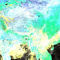
This dataset provides 8-day composite estimates of land surface reflectance from the Suomi NPP VIIRS sensor at a nominal 500m resolution.
The data are corrected for atmospheric conditions and represent the best possible observation over an 8-day period.
The product includes three surface reflectance bands (I1, I2, I3) and two quality assurance layers.
This dataset has been superseded by NASA/VIIRS/002/VNP09H1.
The 8-day Visible Infrared Imaging Radiometer Suite (VIIRS) Surface
Reflectance (VNP09H1) Version 1 composite product provides an estimate of
land surface reflectance from the Suomi National Polar-orbiting Partnership
(Suomi NPP) VIIRS sensor for three imagery bands (I1, I2, I3) at nominal
500m resolution (~463m). The 500m dataset is derived through resampling the
native 375m VIIRS resolution in the L2 input product. The data are corrected
for atmospheric conditions such as the effects of molecular gases, including
ozone and water vapor, and for the effects of atmospheric aerosols. Each
pixel represents the best possible Level 2G observation during an 8-day
period, which is selected on the basis of high observation coverage, low
sensor angle, the absence of clouds or cloud shadow, and aerosol loading.
The three reflectance bands, this product includes a state quality assurance
(QA) layer and a reflectance band quality layer.
0: Corrected product produced at ideal quality all bands
1: Corrected product produced at less than ideal quality some
or all bands
2: Corrected product not produced due to cloud effects all
bands
3: Corrected product not produced due to other reasons some or
all bands may be fill value [Note that a value of (11)
overrides a value of (01)].
Bits 2-3: Cloud State
0: Clear
1: Cloudy
2: Mixed
3: Not set, assumed clear
Bits 4-7: Band 1 data quality four bit range
0: Highest quality
1: Noisy detector
2: Dead detector, data interpolated in L1B
3: Solar zenith >= 86 degrees
4: Solar zenith >= 85 and < 86 degrees
5: Missing input
6: Internal constant used in place of climatological data for
at least one atmospheric constant
7: Correction out of bounds, pixel constrained to extreme
allowable value
8: L1B data faulty
9: Not processed due to deep ocean or clouds
Bits 8-11: Band 2 data quality four bit range
0: Highest quality
1: Noisy detector
2: Dead detector, data interpolated in L1B
3: Solar zenith >= 86 degrees
4: Solar zenith >= 85 and < 86 degrees
5: Missing input
6: Internal constant used in place of climatological data for
at least one atmospheric constant
7: Correction out of bounds, pixel constrained to extreme
allowable value
8: L1B data faulty
9: Not processed due to deep ocean or clouds
Bit 12: Atmospheric correction performed
0: No
1: Yes
Bit 13: Adjacency correction performed
0: No
1: Yes
Bit 14: Different orbit from 500m
0: No
1: Yes
SurfReflect_State_500m
500 meters
Surface Reflectance State Quality Assurance (QA)
Bitmask for SurfReflect_State_500m
Bits 0-1: Cloud state
0: Clear
1: Cloudy
2: Mixed
3: Not set, assumed clear
Bit 2: Cloud shadow
0: No
1: Yes
Bits 3-5: Land/water flag
0: Shallow ocean
1: Land
2: Ocean coastlines and lake shorelines
3: Shallow inland water
4: Ephemeral water
5: Deep inland water
6: Continental/moderate ocean
7: Deep ocean
Bits 6-7: Aerosol quantity
0: Climatology
1: Low
2: Average
3: High
Bits 8-9: Cirrus detected
0: None
1: Small
2: Average
3: High
Bit 10: Cloud shadow
0: No cloud
1: Cloud
Bit 11: Internal fire algorithm flag
0: No Fire
1: Fire
Bit 12: Snow/ice flag
0: No
1: Yes
Bit 13: Pixel is adjacent to cloud
0: No
1: Yes
Bit 14: BRDF correction performed
0: No
1: Yes
Bit 15: Internal snow flag
0: No snow
1: Snow
Terms of Use
Terms of Use
LP DAAC NASA data are freely accessible; however, when an author
publishes these data or works based on the data, it is requested that the
author cite the datasets within the text of the publication and include a
reference to them in the reference list.
The 8-day Visible Infrared Imaging Radiometer Suite (VIIRS) Surface Reflectance (VNP09H1) Version 1 composite product provides an estimate of land surface reflectance from the Suomi National Polar-orbiting Partnership (Suomi NPP) VIIRS sensor for three imagery bands (I1, I2, I3) at nominal 500m resolution (~463m). The 500m dataset is derived through …
[[["Easy to understand","easyToUnderstand","thumb-up"],["Solved my problem","solvedMyProblem","thumb-up"],["Other","otherUp","thumb-up"]],[["Missing the information I need","missingTheInformationINeed","thumb-down"],["Too complicated / too many steps","tooComplicatedTooManySteps","thumb-down"],["Out of date","outOfDate","thumb-down"],["Samples / code issue","samplesCodeIssue","thumb-down"],["Other","otherDown","thumb-down"]],[],[],["This dataset, NOAA/VIIRS/001/VNP09H1, provides 8-day composite estimates of land surface reflectance from the Suomi NPP VIIRS sensor, covering 2012-01-19 to 2024-06-09. It includes three imagery bands (I1, I2, I3) at 500m resolution, corrected for atmospheric conditions. Each pixel represents the best Level 2G observation, selected for high coverage and minimal cloud interference. Quality assurance and state layers are included, with corresponding bitmasks. Users are requested to cite this data in publications. This dataset has been superseded by NASA/VIIRS/002/VNP09H1.\n"]]