Page Summary
-
ETOPO1 is a global relief model providing land topography and ocean bathymetry data.
-
The dataset includes two elevation bands:
ice_surfaceandbedrock. -
ETOPO1 data is publicly available and free to use, with a request to cite NCEI as the source.
- Dataset Availability
- 2008-08-01T00:00:00Z–2008-08-01T00:00:00Z
- Dataset Producer
- NOAA
- Tags
Description
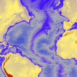
ETOPO1 is a 1 arc-minute global relief model of Earth''s surface that integrates land topography and ocean bathymetry. It was built from numerous global and regional data sets. It contains two elevation bands: ice_surface and bedrock.
Bands
Bands
Pixel size: 1855 meters (all bands)
| Name | Units | Min | Max | Pixel Size | Description |
|---|---|---|---|---|---|
bedrock |
m | -10898* | 8271* | 1855 meters | Elevation at ground level and at the base of the Antarctic and Greenland ice sheets |
ice_surface |
m | -10898* | 8271* | 1855 meters | Elevation at ground level and at the top of the Antarctic and Greenland ice sheets |
Terms of Use
Terms of Use
It is not necessary to obtain written permission to use ETOPO1 or other NOAA products that are in the public domain, nor are there any fees for using them. We ask only that you cite NCEI as source.
Citations
Amante, C. and B. W. Eakins, ETOPO1 1 Arc-Minute Global Relief Model: Procedures, Data Sources and Analysis. NOAA Technical Memorandum NESDIS NGDC-24, 19 pp, March 2009.
DOIs
Explore with Earth Engine
Code Editor (JavaScript)
var dataset = ee.Image('NOAA/NGDC/ETOPO1');
var elevation = dataset.select('bedrock');
var elevationVis = {
  min: -7000.0,
  max: 3000.0,
  palette: ['011de2', 'afafaf', '3603ff', 'fff477', 'b42109'],
};
Map.setCenter(-37.62, 25.8, 2);
Map.addLayer(elevation, elevationVis, 'Elevation');