Page Summary
-
This dataset offers a high-quality Climate Data Record (CDR) of global infrared measurements from geostationary satellites.
-
The dataset, provided by NOAA, includes data from the infrared window, visible, and infrared water vapor channels.
-
Data is available from 1980-01-01 to 2024-09-30, with a cadence of 3 hours, but has not been updated since 2024-03-31.
-
The GridSat-B1 data is projected onto a global 0.07 degree latitude equal-angle grid and is sourced from the 3-hourly ISCCP B1 data.
-
The
irwin_cdrband provides brightness temperature near 11µm, whileirwvpandvschnbands offer brightness temperature near 6.7µm and visible reflectance near 0.6µm respectively, with notes on their quality and corrections.
- Dataset Availability
- 1980-01-01T00:00:00Z–2024-09-30T21:00:00Z
- Dataset Producer
- NOAA
- Cadence
- 3 Hours
- Tags
Description
This dataset provides a high quality Climate Data Record (CDR) of global infrared measurements from geostationary satellites.
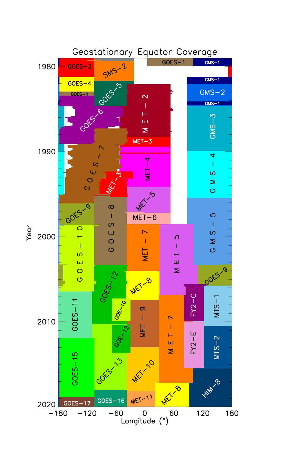
The geostationary satellite data (GridSat-B1) provides data from 3 channels: the CDR-quality infrared window (IRWIN) channel (near 11µm), the visible channel (near 0.6µm) and the infrared water vapor (IRWVP) channel (near 6.7µm). The GridSat-B1 data is projected onto a global 0.07 degree latitude equal-angle grid with date coverage spanning from 1980-present. This data is sourced from the 3-hourly International Satellite Cloud Climatology Project (ISCCP) B1 data. The satellites included in this dataset with their longitudinal coverage over time can be seen here. In regions of overlap the CDR methodology merges satellites by selecting the nadir-most observations for each grid point.
Notes:
Mappings from satid to satellite name are contained in the image's properties as satid_number: "satellite_name", e.g. satid_0: GOES-13, satid_1: GOES-15, and satid_2: GOES-16.
IRWIN data has been corrected for view zenith angle, but this correction is not perfect. It also treats all satellites the same way, whereas the view zenith angle dependence will vary by satellite. Some VZA residual will be apparent.
IRWVP data has no view zenith angle correction and is not CDR quality.
VSCHN data has no view zenith angle corrections and is not CDR quality.
Removing the View Zenigth Angle correction for the IRWIN channels can be done with the following: Original_temperature_observed = irwin_cdr - irwin_vza_adj
Bands
Bands
Pixel size: 7792 meters (all bands)
| Name | Units | Min | Max | Scale | Offset | Pixel Size | Description |
|---|---|---|---|---|---|---|---|
irwin_cdr |
K | -2093* | 13615* | 0.01 | 200 | 7792 meters | Brightness temperature near 11µm, nadir-most observation |
irwin_2 |
K | -4123* | 13579* | 0.01 | 200 | 7792 meters | Brightness temperature near 11µm, second-best observation (based on view zenith angle) |
irwin_3 |
K | -1624* | 14240* | 0.01 | 200 | 7792 meters | Brightness temperature, third-best observation based on view zenith angle |
irwvp |
K | -5907* | 10219* | 0.01 | 200 | 7792 meters | Brightness temperature near 6.7µm, nadir-most observation |
irwvp_2 |
K | -5081* | 10260* | 0.01 | 200 | 7792 meters | Brightness temperature near 6.7µm, second-best observation based on view zenith angle |
vschn |
-25000* | 4275* | 4e-05 | 1 | 7792 meters | Visible reflectance near 0.6µm, nadir-most observation |
|
vschn_2 |
-25000* | 3800* | 4e-05 | 1 | 7792 meters | Visible reflectance near 0.6µm, second-best observation based on view zenith angle |
|
irwin_vza_adj |
K | 36* | 171* | 0.25 | -10 | 7792 meters | Adjustment made to all IRWIN channels. Provided to allow users to reverse the view zenith correction for the irwin_cdr variable. |
satid_ir1 |
0* | 5* | 7792 meters | satid values for irwin_cdr. For this and other satid bands, the mappings of satid to satellite name are given in the properties for each image |
|||
satid_ir2 |
0* | 5* | 7792 meters | satid values per pixel for irwin_2 |
|||
satid_ir3 |
0* | 5* | 7792 meters | satid values per pixel for irwin_3 |
|||
satid_wv1 |
0* | 5* | 7792 meters | satid values per pixel for irwvp |
|||
satid_wv2 |
0* | 5* | 7792 meters | satid values per pixel for irwvp2 |
|||
satid_vs1 |
0* | 5* | 7792 meters | satid values per pixel for vischn |
|||
satid_vs2 |
0* | 5* | 7792 meters | satid values per pixel for vischn2 |
Image Properties
Image Properties
| Name | Type | Description |
|---|---|---|
| satid_0 | STRING | Satellite name (see notes) |
| satid_1 | STRING | Satellite name (see notes) |
| satid_2 | STRING | Satellite name (see notes) |
| satid_3 | STRING | Satellite name (see notes) |
| satid_4 | STRING | Satellite name (see notes) |
| satid_5 | STRING | Satellite name (see notes) |
Terms of Use
Terms of Use
The NOAA CDR Program's official distribution point for CDRs is NOAA's National Climatic Data Center which provides sustained, open access and active data management of the CDR packages and related information in keeping with the United States' open data policies and practices as described in the President's Memorandum on "Open Data Policy" and pursuant to the Executive Order of May 9, 2013, "Making Open and Machine Readable the New Default for Government Information". In line with these policies, the CDR data sets are nonproprietary, publicly available, and no restrictions are placed upon their use. For more information, see the Fair Use of NOAA's CDR Data Sets, Algorithms and Documentation pdf.
Citations
Kenneth R. Knapp, and NOAA CDR Program (2014): NOAA Climate Data Record (CDR) of Gridded Satellite Data from ISCCP B1 (GridSat-B1) 11 micron Brightness Temperature, Version 2. [indicate subset used]. NOAA National Climatic Data Center. doi:10.7289/V59P2ZKR [access date].
Knapp, K. R., S. Ansari, C. L. Bain, M. A. Bourassa, M. J. Dickinson, C. Funk, C. N. Helms, C. C. Hennon, C. D. Holmes, G. J. Huffman, J. P. Kossin, H.-T. Lee, A. Loew, and G. Magnusdottir, 2011: Globally gridded satellite (GridSat) observations for climate studies. Bulletin of the American Meteorological Society, 92, 893-907. doi:10.1175/2011BAMS3039.1
DOIs
Explore with Earth Engine
Code Editor (JavaScript)
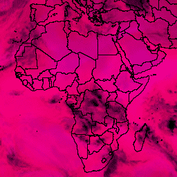
var dataset = ee.ImageCollection('NOAA/CDR/GRIDSAT-B1/V2')
                  .filter(ee.Filter.date('2017-05-01', '2017-05-14'));
var brightnessTemp = dataset.select(['irwin_cdr', 'vschn', 'irwvp']);
var brightnessTempVis = {
  min: 500.0,
  max: 10000.0,
};
Map.setCenter(7.71, 17.93, 2);
Map.addLayer(brightnessTemp, brightnessTempVis, 'Brightness Temperature');