Page Summary
-
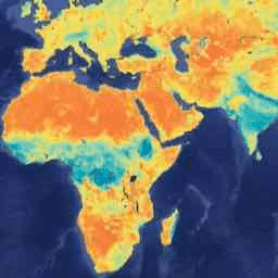
This dataset provides a daily composite of global land surface conditions, specifically soil moisture, retrieved by the SMAP L-Band radiometer.
-
Data in this collection covers the period from 2015-03-31 to 2023-12-03, with newer data available in a different collection.
-
The SMAP mission measures the amount of water in the surface soil globally every 2-3 days and can distinguish between frozen and thawed ground.
-
The dataset includes various bands providing information on soil moisture, brightness temperatures, vegetation water content, and quality flags for both AM and PM passes.
- Dataset Availability
- 2015-03-31T12:00:00Z–2023-12-03T12:00:00Z
- Dataset Producer
- Google and NSIDC
- Cadence
- 1 Day
- Tags
Description
Data starting from 2023-12-04 are available in the NASA/SMAP/SPL3SMP_E/006 collection.
This Level-3 (L3) soil moisture product provides a daily composite of global land surface conditions retrieved by the Soil Moisture Active Passive (SMAP) L-Band radiometer. The daily data here were collected from the descending (local solar time of 6 am) and ascending (local solar time of 6 pm) passes.
The SMAP mission is an orbiting observatory that measures the amount of water in the surface soil everywhere on Earth. A detailed description can be found in the SMAP Handbook. It was launched in January 2015 and started operation in April 2015. The radar instrument, ceasing operation in early 2015 due to failure of radar power supply, collected close to 3 months of science data. The prime mission phase of three years was completed in 2018, and since then SMAP has been in extended operation phase.
SMAP measures soil moisture every 2-3 days. This permits changes around the world to be observed over time scales ranging from major storms to repeated measurements of changes over the seasons.
Everywhere on Earth not covered with water or not frozen, SMAP measures how much water is in the top layer of soil. It also distinguishes between ground that is frozen or thawed. Where the ground is not frozen, SMAP measures the amount of water found between the minerals, rocky material, and organic particles found in soil everywhere in the world (SMAP measures liquid water in the top layer of ground but is not able to measure the ice.)
SPL3SMP_E data are transformed to geographic coordinates using GDAL libraries before the data are ingested into Google Earth Engine.
See the SMAP L3 Soil Moisture User Guide and references therein for additional documentation and algorithm details.
See basic and advanced tutorials to learn how to use SMAP data in Earth Engine.
Bands
Bands
Pixel size: 9000 meters (all bands)
| Name | Units | Min | Max | Pixel Size | Description |
|---|---|---|---|---|---|
soil_moisture_am |
Volume fraction | 9000 meters | Retrieved soil moisture estimate from the disaggregated/downscaled vertical polarization brightness temperature at 9-km grid cell; AM overpass |
||
tb_h_corrected_am |
K | 0 | 330 | 9000 meters | Weighted average of horizontally polarized brightness temperatures. This value represents the corrected land brightness temperature if the water fraction is lower than 0.9 (otherwise no correction is applied) or represents the corrected water brightness temperature if the water fraction is greater than 0.1 (otherwise no correction is applied); AM overpass |
tb_v_corrected_am |
K | 0 | 330 | 9000 meters | Weighted average of vertically polarized brightness temperatures. This value represents the corrected land brightness temperature if the water fraction is lower than 0.9 (otherwise no correction is applied) or represents the corrected water brightness temperature if the water fraction is greater than 0.1 (otherwise no correction is applied); AM overpass |
vegetation_water_content_am |
kg/m^2 | 0 | 30 | 9000 meters | Vegetation water content at 9-km spatial scale. This parameter is used as input ancillary data parameter to the SPL2SMAP processing software when the baseline algorithm is used. The valid minimum and maximum below are subject to further analysis. AM overpass |
retrieval_qual_flag_am |
0 | 65536 | 9000 meters | 0 = Pass: Soil moisture with acceptable quality; 1 = Fail: Soil moisture does with unacceptable quality; AM overpass |
|
tb_qual_flag_h_am |
0 | 65536 | 9000 meters | 0= brightness temperatures with unacceptable quality; 1= brightness temperatures with acceptable quality; AM overpass |
|
tb_qual_flag_v_am |
0 | 65536 | 9000 meters | 0= brightness temperatures with unacceptable quality; 1= brightness temperatures with acceptable quality; AM overpass |
|
soil_moisture_pm |
Volume fraction | 9000 meters | Retrieved soil moisture estimate from the disaggregated/downscaled vertical polarization brightness temperature at 9-km grid cell; PM overpass |
||
tb_h_corrected_pm |
K | 0 | 330 | 9000 meters | Weighted average of horizontally polarized brightness temperatures. This value represents the corrected land brightness temperature if the water fraction is lower than 0.9 (otherwise no correction is applied) or represents the corrected water brightness temperature if the water fraction is greater than 0.1 (otherwise no correction is applied); PM overpass |
tb_v_corrected_pm |
K | 0 | 330 | 9000 meters | Weighted average of vertically polarized brightness temperatures. This value represents the corrected land brightness temperature if the water fraction is lower than 0.9 (otherwise no correction is applied) or represents the corrected water brightness temperature if the water fraction is greater than 0.1 (otherwise no correction is applied); PM overpass |
vegetation_water_content_pm |
kg/m^2 | 0 | 30 | 9000 meters | Vegetation water content at 9-km spatial scale. This parameter is used as input ancillary data parameter to the SPL2SMAP processing software when the baseline algorithm is used. The valid minimum and maximum below are subject to further analysis. PM overpass |
retrieval_qual_flag_pm |
0 | 65536 | 9000 meters | 0 = Pass: Soil moisture with acceptable quality; 1 = Fail: Soil moisture does with unacceptable quality; PM overpass |
|
tb_qual_flag_h_pm |
0 | 65536 | 9000 meters | 0= brightness temperatures with unacceptable quality; 1= brightness temperatures with acceptable quality; PM overpass |
|
tb_qual_flag_v_pm |
0 | 65536 | 9000 meters | 0= brightness temperatures with unacceptable quality; 1= brightness temperatures with acceptable quality; PM overpass |
|
soil_moisture_am_anomaly |
9000 meters | Experimental. Difference of the 30-day average of 'soil_moisture_am', centered on asset date, relative to the same 30-day period averaged across years from 2015 to present, excluding asset year. See this script for anomaly computations. |
|||
soil_moisture_pm_anomaly |
9000 meters | Experimental. Difference of the 30-day average of 'soil_moisture_pm', centered on asset date, relative to the same 30-day period averaged across years from 2015 to present, excluding asset year. See this script for anomaly computations. |
Terms of Use
Terms of Use
This dataset is in the public domain and is available without restriction on use and distribution. See NASA's Earth Science Data & Information Policy for additional information.
Citations
**O'Neill, P. E., S. Chan, E. G. Njoku, T. Jackson, R. Bindlish, J. Chaubell, and A. Colliander. 2021. SMAP Enhanced L3 Radiometer Global and Polar Grid Daily 9 km EASE-Grid Soil Moisture, Version 5. [Indicate subset used]. Boulder, Colorado USA. NASA National Snow and Ice Data Center Distributed Active Archive Center. doi:10.5067/4DQ54OUIJ9DL
Entekhabi et al., 2014 D. Entekhabi, S. Yueh, P. O'Neill, K. Kellogg et al. SMAP Handbook - Soil Moisture Active Passive: Mapping Soil Moisture and Freeze/thaw From Space. SMAP Project, Jet Propulsion Laboratory, Pasadena, CA (2014) SMAP Handbook
Chan, S. K., R. Bindlish, P. E. O'Neill, E. Njoku, T. Jackson, A. Colliander, F. Chen, M. Burgin, S. Dunbar, J. Piepmeier, S. Yueh, D. Entekhabi, M. H. Cosh, T. Caldwell, J. Walker, X. Wu, A. Berg, T. Rowlandson, A. Pacheco, H. McNairn, M. Thibeault, J. Martinez-Fernandez, A. Gonzalez-Zamora, M. Seyfried, D. Bosch, P. Starks, D. Goodrich, J. Prueger, M. Palecki, E. E. Small, M. Zreda, J.-C. Calvet, W. T. Crow, and Y. Kerr. 2016. "Assessment of the SMAP Passive Soil Moisture Product" IEEE Transactions on Geoscience and Remote Sensing, 54 (8): 4994-5007 10.1109/tgrs.2016.2561938
Chan, S., R. Bindlish, P. O'Neill, T. Jackson, E. Njoku, S. Dunbar, J. Chaubell, J. Piepmeier, S. Yueh, D. Entekhabi, A. Colliander, F. Chen, M. Cosh, T. Caldwell, J. Walker, A. Berg, H. McNairn, M. Thibeault, J. Martínez-Fernández, F. Uldall, M. Seyfried, D. Bosch, P. Starks, C. Holifield Collins, J. Prueger, R. van der Velde, J. Asanuma, M. Palecki, E. Small, M. Zreda, J. Calvet, W. Crow, and Y. Kerr. 2018. "Development and assessment of the SMAP enhanced passive soil moisture product." Remote Sensing of Environment, 204: 931-941 10.1016/j.rse.2017.08.025
Chaubell, M. J., J. Asanuma, A. A. Berg, D. D. Bosch, T. Caldwell, M. H. Cosh, C. H. Collins, J. Martinez-Fernandez, M. Seyfried, P. J. Starks, Z. Su, S. H. Yueh, M. Thibeault, J. Walker, R. S. Dunbar, A. Colliander, F. Chen, S. K. Chan, D. Entekhabi, R. Bindlish, and P. E. O'Neill. 2020. "Improved SMAP Dual-Channel Algorithm for the Retrieval of Soil Moisture." IEEE Transactions on Geoscience and Remote Sensing, 1-12 10.1109/tgrs.2019.2959239
DOIs
Explore with Earth Engine
Code Editor (JavaScript)
var dataset = ee.ImageCollection('NASA/SMAP/SPL3SMP_E/005')
                  .filter(ee.Filter.date('2017-04-01', '2017-04-30'));

var soilMositureSurface = dataset.select('soil_moisture_am');
var soilMositureSurfaceVis = {
  min: 0.0,
  max: 0.5,
  palette: ['0300ff', '418504', 'efff07', 'efff07', 'ff0303'],
};
Map.setCenter(-6.746, 46.529, 2);
Map.addLayer(soilMositureSurface, soilMositureSurfaceVis, 'Soil Mositure');