Page Summary
-
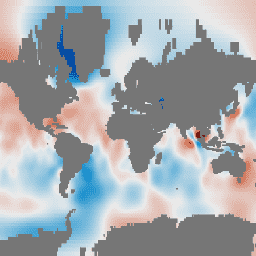
This dataset provides monthly gravitational anomalies over the ocean from the GRACE mission, expressed as "Equivalent Water Thickness" in centimeters.
-
The data is produced by three centers (CSR, GFZ, and JPL), and using the mean of their results is recommended.
-
This dataset is optimized for examining regional ocean bottom pressure and is not intended for calculating global mean ocean mass.
-
A superseded version of this dataset is available as NASA/GRACE/MASS_GRIDS_V04/OCEAN.
- Dataset Availability
- 2002-07-31T00:00:00Z–2016-12-10T00:00:00Z
- Dataset Producer
- NASA Jet Propulsion Laboratory
- Tags
Description
GRACE Tellus Monthly Mass Grids provides monthly gravitational anomalies relative to a 2004-2010 time-mean baseline. The data contained in this dataset are units of "Equivalent Water Thickness" which represent the deviations of mass in terms of vertical extent of water in centimeters. See the provider's Monthly Mass Grids Overview for more details.
The GRACE Tellus (GRCTellus) Monthly Mass Grids Ocean dataset is produced by three centers: CSR (U. Texas / Center for Space Research), GFZ (GeoForschungsZentrum Potsdam), and JPL (NASA Jet Propulsion Laboratory). Each center is a part of the GRACE Ground System and generates Level-2 data (spherical harmonic fields) used in this dataset. The output includes spherical harmonic coefficients of the gravity field and of the dealiasing fields used to compute them. Since each center independently produces the coefficients, the results may be slightly different. It is recommended for most users to use the mean of all three datasets. See the provider's choosing a solution page for more details.
Note
Land leakage correction: Ocean signals are typically weaker than land signals, by factors of 2 and more, on seasonal and interannual time scales. To minimize leakage from high land signals onto ocean signals, a destriping filter has been applied which may cause cause correlations over much larger distances.
The GRCTellus Ocean datasets are optimized to examine regional ocean bottom pressure, but NOT intended to be spatially averaged to determine global mean ocean mass.
A filtered version of the GRCTellus Ocean dataset is also available which uses an alternative filtering method which may reduce leakage errors, and have results which agree better with altimetric sea surface height. NASA/GRACE/MASS_GRIDS/OCEAN_EOFR.
Bands
Pixel Size
111320 meters
Bands
| Name | Units | Min | Max | Pixel Size | Description |
|---|---|---|---|---|---|
lwe_thickness_csr |
cm | -27* | 36.81* | meters | Equivalent liquid water thickness in centimeters calculated by CSR. |
lwe_thickness_gfz |
cm | -28.87* | 33.02* | meters | Equivalent liquid water thickness in centimeters calculated by GFZ. |
lwe_thickness_jpl |
cm | -26.03* | 37.36* | meters | Equivalent liquid water thickness in centimeters calculated by JPL. |
Image Properties
Image Properties
| Name | Type | Description |
|---|---|---|
| CSR_END_TIME | DOUBLE | End date in milliseconds of spherical harmonics solution from CSR. |
| CSR_START_TIME | DOUBLE | Start date in milliseconds of spherical harmonics solution from CSR. |
| GFZ_END_TIME | DOUBLE | End date in milliseconds of spherical harmonics solution from GFZ. |
| GFZ_START_TIME | DOUBLE | Start date in milliseconds of spherical harmonics solution from GFZ. |
| JPL_END_TIME | DOUBLE | End date in milliseconds of spherical harmonics solution from JPL. |
| JPL_START_TIME | DOUBLE | Start date in milliseconds of spherical harmonics solution from JPL. |
Terms of Use
Terms of Use
All NASA-produced data from the GRACE mission is made freely available for the public to use. When using any of the GRCTellus data, please add an acknowledgment: "GRACE land are available at https://grace.jpl.nasa.gov, supported by the NASA MEaSUREs Program." and cite with the citations provided.
Citations
D.P. Chambers. 2012. GRACE MONTHLY OCEAN MASS GRIDS NETCDF RELEASE 5.0. Ver. 5.0. PO.DAAC, CA, USA. Dataset accessed [YYYY-MM-DD] at https://doi.org/10.5067/TEOCN-0N005.
Chambers, D.P. and J.A. Bonin: Evaluation of Release 05 time-variable gravity coefficients over the ocean. Ocean Science 8, 859-868, 2012. https://www.ocean-sci.net/8/859/2012.
Chambers D.P. and J. K. Willis: A Global Evaluation of Ocean Bottom Pressure from GRACE, OMCT, and Steric-Corrected Altimetry. J. of Oceanic and Atmosph. Technology, vol 27, pp 1395-1402. doi:10.1175/2010JTECHO738.1, 2010.
DOIs
Explore with Earth Engine
Code Editor (JavaScript)
var dataset = ee.ImageCollection('NASA/GRACE/MASS_GRIDS/OCEAN')
                  .filter(ee.Filter.date('2016-08-01', '2016-08-30'));
var equivalentWaterThicknessCsr = dataset.select('lwe_thickness_csr');
var equivalentWaterThicknessCsrVis = {
  min: -10.0,
  max: 10.0,
};
Map.setCenter(6.746, 46.529, 1);
Map.addLayer(
    equivalentWaterThicknessCsr, equivalentWaterThicknessCsrVis,
    'Equivalent Water Thickness CSR');